Jns2183
-
Posts
5,838 -
Joined
-
Last visited
Content Type
Profiles
Blogs
Forums
American Weather
Media Demo
Store
Gallery
Everything posted by Jns2183
-
There is a dryline in Missouri. How often do you ever see that. Sent from my SM-G970U using Tapatalk
-
Might be IQ limit Sent from my SM-G970U using Tapatalk
-
I feel like a real life meeting of all mid Atlantic posters would result in a mass casualty event Sent from my SM-G970U using Tapatalk
-
Spicy spicy Sent from my SM-G970U using Tapatalk
-
5-10 feet of snow up by Tahoe incoming Sent from my SM-G970U using Tapatalk
-
I'm nicknaming my new rift on the Hemingway Daiquiri "the Canderson Daiquiri" Sent from my SM-G970U using Tapatalk
-
Looks like rain will miss Harrisburg to the north. Just like all summer Sent from my SM-G970U using Tapatalk
-
Denver snowstorm. Their snowiest months of the year are March/April Sent from my SM-G970U using Tapatalk
-
At that time of year we either need that dark dark blue over us or thread the needle with a bomb over OCMD Sent from my SM-G970U using Tapatalk
-
Go to the love shack in shermansdale Sent from my SM-G970U using Tapatalk
-
Last may and June were not my cup of tea. I crave those week long cut of lows with 6" of rain Sent from my SM-G970U using Tapatalk
-
My daughter goes to an outdoor adventure day camp at roundtop for a week each summer. She loves it. Sent from my SM-G970U using Tapatalk
-
Orange, better than red. And good is very relative here Sent from my SM-G970U using Tapatalk
-
For once we are in a good hole Sent from my SM-G970U using Tapatalk

-
Watch em get a 40" April Sent from my SM-G970U using Tapatalk
-
I want some of that lightning Sent from my SM-G970U using Tapatalk
-
We are in prime summer form with rain collapsing only over Harrisburg Sent from my SM-G970U using Tapatalk
-
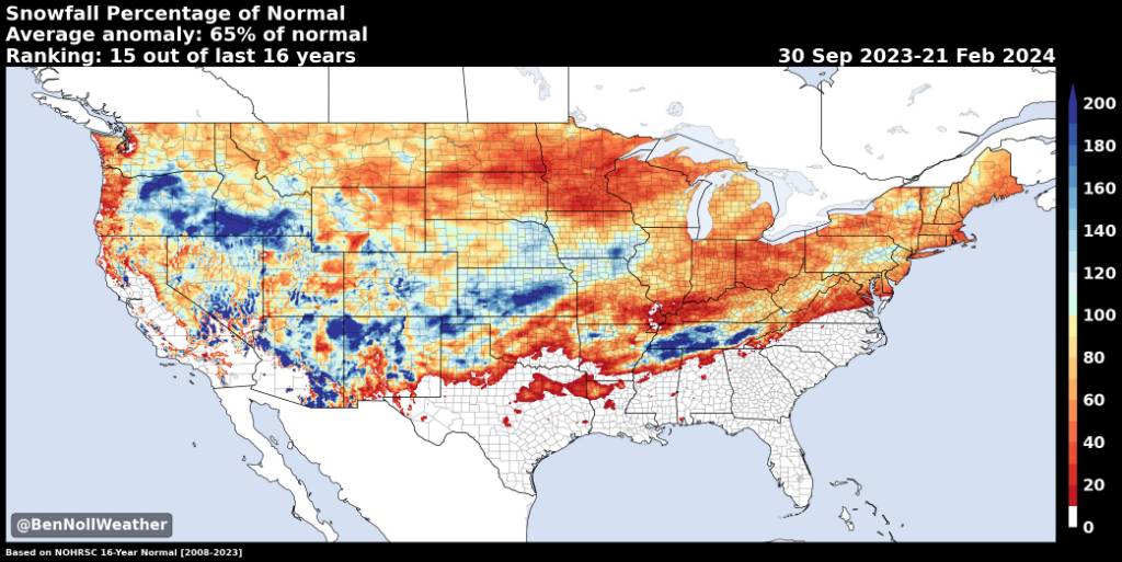
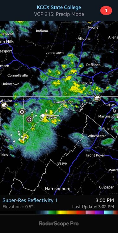
Do we get any thunder in southern areas. I see lightning in northern WV Sent from my SM-G970U using Tapatalk
-
I picture you as the Japanese kid on the tricycle shotgunning a beer Sent from my SM-G970U using Tapatalk
-
I picture you hosting a "revenge of the nerds" style lawn & garden competition Sent from my SM-G970U using Tapatalk
-
Id require them successfully shotgunning a Busch ice before being allowed to enter Sent from my SM-G970U using Tapatalk
-
Not for refined souls outside of our little Appalachia paradise Sent from my SM-G970U using Tapatalk
-
So pipes don't freeze to keep bathroom and water on Sent from my SM-G970U using Tapatalk
-
Maybe if your lucky @canderson will see a show near you Sent from my SM-G970U using Tapatalk
-
You need a Google doc with guidelines Sent from my SM-G970U using Tapatalk