Jns2183
-
Posts
5,838 -
Joined
-
Last visited
Content Type
Profiles
Blogs
Forums
American Weather
Media Demo
Store
Gallery
Everything posted by Jns2183
-
I feel they must have almost all time low confidence in their forcast Sent from my SM-G970U using Tapatalk
-
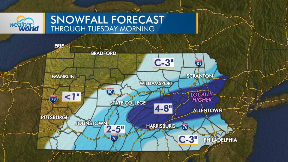
Weather world Sent from my SM-G970U using Tapatalk
-
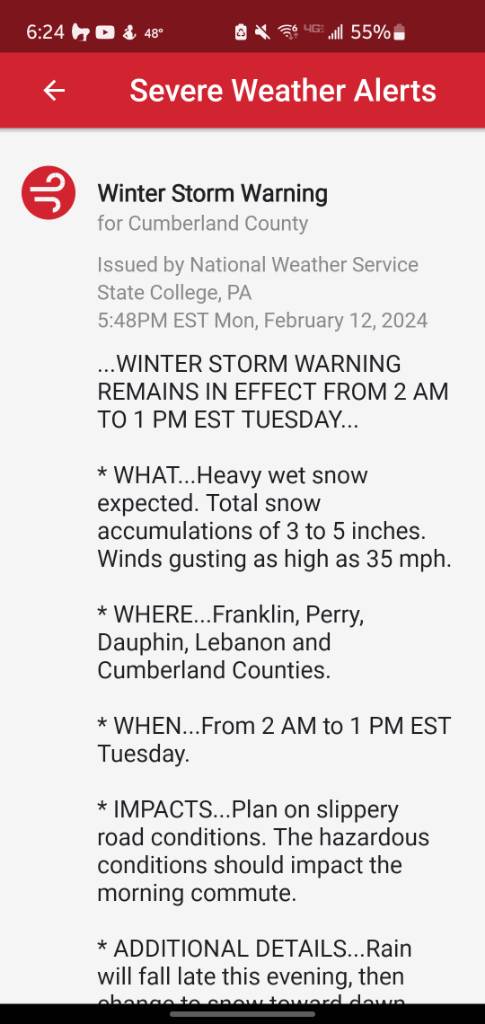
I guess they settled on 3-5" Sent from my SM-G970U using Tapatalk
-
I think it may be easy to think of it this way. Mid Dec December to Mid March is 16 weeks. Over 10 years that's 160 weeks. Out of those 160 weeks I'd say we get 4-8 that match what you would consider the perfect pattern that deliver. The violtility produced from The change between patterns, good/bad also tend to be associated more with our bigger storms. Sent from my SM-G970U using Tapatalk
-
That low is in bad position. Even if we had artic air in place all it would be a bad ice storm Sent from my SM-G970U using Tapatalk
-
My goal is 10" Sent from my SM-G970U using Tapatalk
-
For good luck Sent from my SM-G970U using Tapatalk
-
Old turnpike? Sent from my SM-G970U using Tapatalk
-
OMG the shipping cost Sent from my SM-G970U using Tapatalk
-
Did he send them from Honolulu? Sent from my SM-G970U using Tapatalk
-
Trying to get you out gardening earlier. Have you had any good cocktails recently? Sent from my SM-G970U using Tapatalk
-
Wow, so he's basically calling for 3 weeks or greater like that week in January we had. Or a mecs to HECS. Sent from my SM-G970U using Tapatalk
-
That makes me question measurement methods as bubbler said. If Chester county is similar I'll buy that a demarcation line from hell set up over our forum for awhile. Sent from my SM-G970U using Tapatalk
-
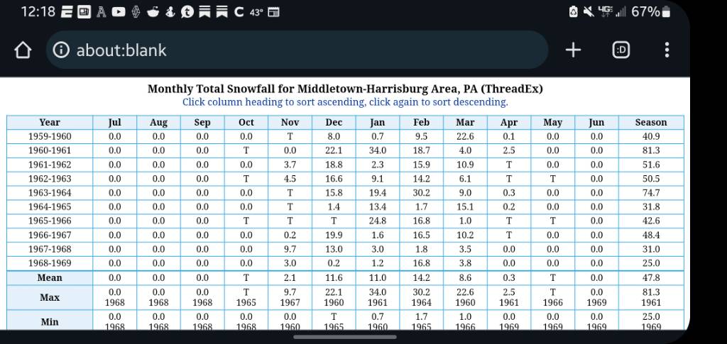
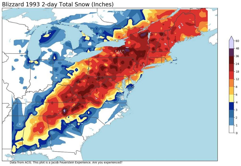
1994 and 1996 were over 70" I believe Sent from my SM-G970U using Tapatalk
-
Compare that with the 70 years before to blow your mind even more Sent from my SM-G970U using Tapatalk
-
When I say the 1960s were insane I mean it. They literally had a +50% variance in decade average snowfall out of nowhere; forever tilting snow records so every year seems low. I can't find an anomaly so great in any other main weather variable over a decade. Sent from my SM-G970U using Tapatalk
-
If this is accurate thank God the Internet did not exist back then. The fair weather weenies on the forums would have rioted or jumped off a cliff Sent from my SM-G970U using Tapatalk
-
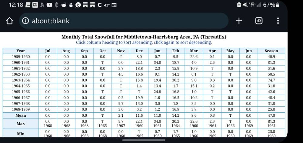
Do you have link to daily obs for those years Sent from my SM-G970U using Tapatalk
-
The Harrisburg results are certified. I'll have to look at Chester county later to compare Sent from my SM-G970U using Tapatalk
-
1961-1964 is insane. 20" less per year. Especially 62'&64'. Basically half of what Harrisburg got Sent from my SM-G970U using Tapatalk
-
Would love to see Lancaster data Sent from my SM-G970U using Tapatalk
-
Here you go to compare Sent from my SM-G970U using Tapatalk
-
Yes. Now KMDT was were KCXY is now back then Sent from my SM-G970U using Tapatalk
-
The 1960's we averaged 47". No other decade was more than 36" since 1890 besides the 60's. Figures it was that decade Sent from my SM-G970U using Tapatalk
-
People don't realize that from 1930-1960 we averaged 28" of snow a year From 1990-2020 we averaged 30" Sent from my SM-G970U using Tapatalk