Natester
-
Posts
1,223 -
Joined
-
Last visited
Content Type
Profiles
Blogs
Forums
American Weather
Media Demo
Store
Gallery
Everything posted by Natester
-
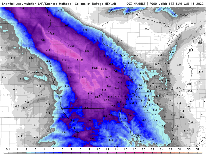
18z NAM 3k says Hoosier gets sleetfest.
-
NAM 12k and NAM 3k aren't budging.
-
I meant in Missouri and Illinois LOL.
-
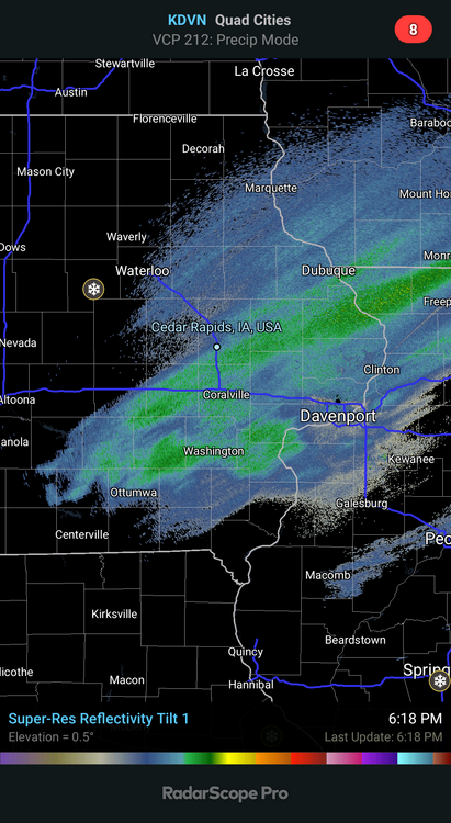
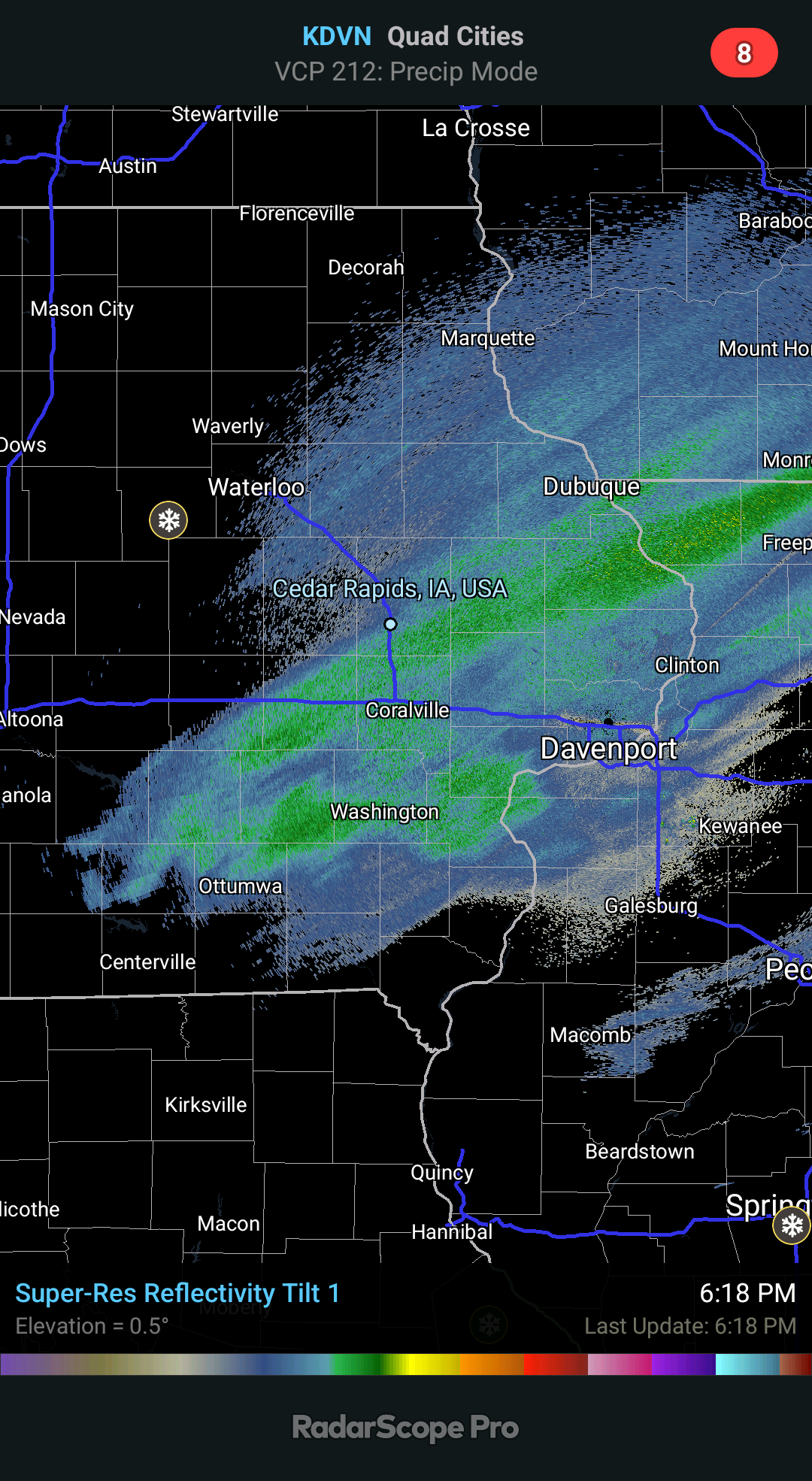
Well on the bright side any ice Cedar Rapids gets will be light, maybe just under a tenth of an inch. However as Hoosier said earlier, just a tenth of an inch of ice with strong winds can cause problems.
-
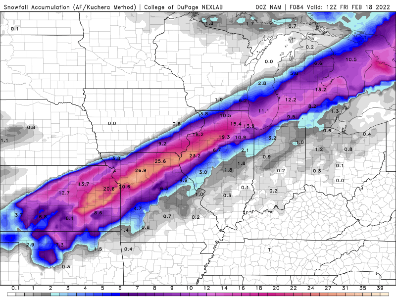
Ridiculous snow forecast totals. Totally overdone.
-
Not amped at all on the 0z NAM 12k at hour 84.
-
0z ICON back south again in line with the other models.
-
Not sure if any of you saw the 18z ICON, but it's waay north, with the sleet/zr zone in SE Iowa and NW Illinois.
-
Well, 4-5 inches is better than nothing.
-
If it keeps snowing this lightly Cedar Rapids will only end up with 4-5 inches of snow.
-
Hawkeye (and others) is going to have a hard time shoveling this snow since it's very wet in nature.
-
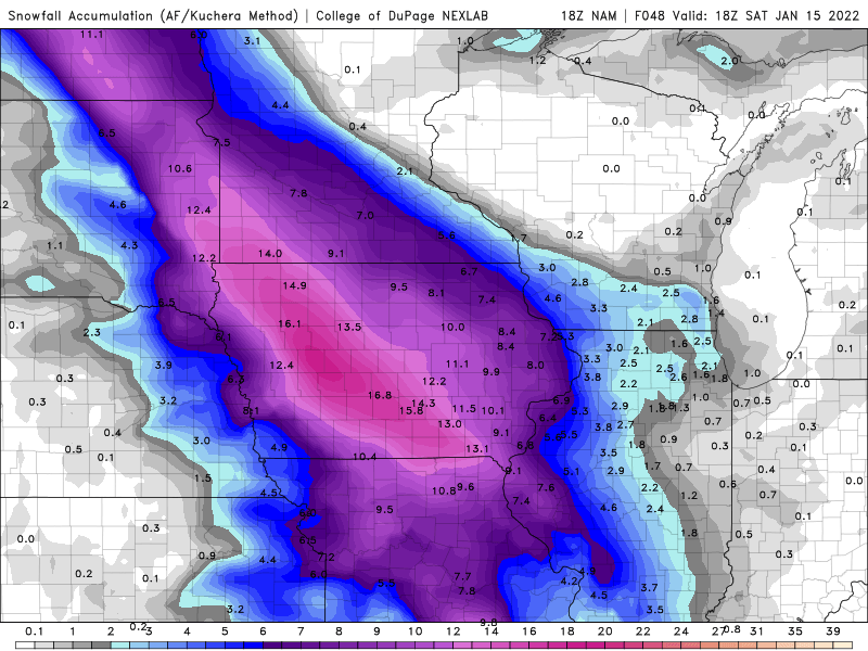
From DVN: UPDATE ISSUED AT 809 PM CST THU JAN 13 2022 18Z GUIDANCE, SPECIFICALLY THE NAM BRINGS MORE SNOW ACCUMULATION FURTHER EAST. DIVING INTO THE DETAILS OF WHY THIS HAPPENS AND WHAT WE NEED TO SEE IN 00Z GUIDANCE TO SEE IF THIS IS A FLUKE OR A TREND FOLLOWS. SNOWFALL ACCUMULATION IN THE 18Z NAM RAMPS UP FROM 21Z TO 03Z AND DROPS CLOSE TO 3/4 TO ONE INCH AN HOUR FOR A FEW HOURS. THIS IS WHAT INCREASE THE EASTERN SNOW TOTALS. LOOKING TO FORCING, THE OMEGAS IN THE DGZ PEAK EARLY IN THE NAM, 15 TO 21Z AND THEN FALL THROUGHOUT THE EVENT. TRUE WE GET COLDER, BUT WE SEE MORE CLIMO SNOW RATIOS AT THIS TIME. THIS EASTERN EXTENSION OF THE HIGHER SNOW AMOUNTS DON'T SEEM TO BE TIED WITH THE HEAVIER AXIS SHIFTING EAST, AS MUCH AS ADDITIONAL SNOW THERE. THE CLIPPER AND BETTER CVA ARE WEST OF THE AREA, WHERE MODELS HAVE CONSISTENTLY HAD THE HEAVIEST SNOWFALL. THE NBM HAS TRENDED EAST WITH AN ADDITIONAL INCH OR SO TO TOTALS, LIKELY FROM THE 18Z GUIDANCE. THE 00Z NAM IS STARTING TO COME IN AND IS BACKING OFF ALL SO SLIGHTLY FROM THE 18Z WITH EASTERN AMOUNTS. WILL NEED TO KEEP AN EYE ON 00Z GFS ALONG WITH ENSEMBLE DATA, WHICH CONTINUES TO SUGGEST THE CURRENT FORECAST IS CORRECT. WHILE THE DIFFERENCES HERE ARE AMOUNTS, THE IMPACTS ARE LIKELY TO BE UNCHANGED UNLESS WE CAN SEE 1+ INCHES AND HOUR AND DRIER SNOW BLOWING AROUND. WITH WET SNOW TO START, ONE WOULD THINK THAT THE CURRENT SNOWPACK WOULD BE MORE STICKY TO THAT THAN DRIER SNOW. 00Z GUIDANCE, ESPECIALLY ENSEMBLES WILL HELP FINE TUNE FORECAST OVERNIGHT. THE 00Z HRRR IS IN AND, WHILE NOT AS AGGRESSIVE AS THE 18Z NAM, DOES HAVE MORE SNOW EAST. THIS SOLUTION WOULD POINT TOWARDS A POSSIBLE EXTENSION OF THE WARNING EAST BY ONE COLUMN OF COUNTIES.
-
-
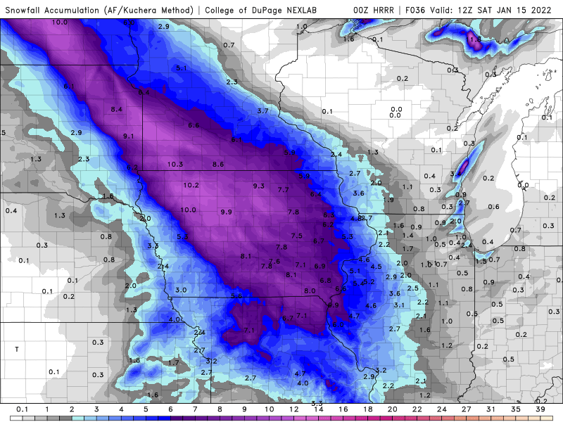
Weenie 0z HRRR snow total map (kuchera).
-
These totals on the NAM 12k are way overdone. I would say toss. The 18z NAM 3k has more realistic totals and placement of the snow axis.
-
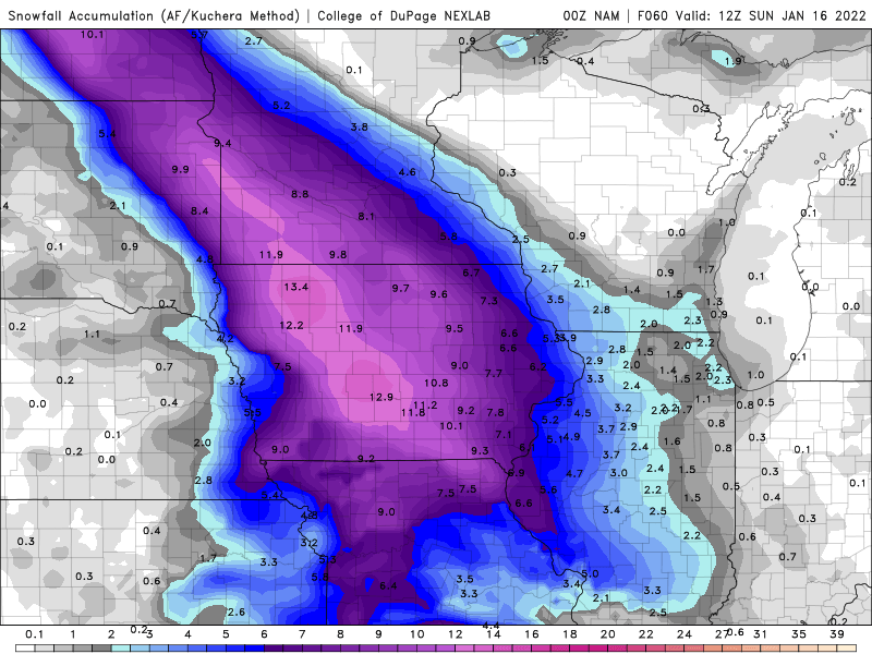
I wouldn't be surprised if Cedar Rapids got nothing from this, to the dismay of hawkeye_wx, hlcater and myself. Very unlikely that would happen though, but I'm only expecting 2-3 inches here but the globals forecast more than that (except the Euro).
-
Can't win them all as they say. Yeah, RAP is a toss. I would also like to point out that the 18z NAM 3k shuts out Cedar Rapids, which wouldn't be surprising lol. Got lucky with the January 1 storm, can't be lucky twice in a row. EDIT: Just checked the forecast snow totals on the 18z RGEM for eastern Iowa. Has several inches of snow in Cedar Rapids (likely way overdone). I would think that 2-3 inches is more realistic although it's still 36 hours out.
-
Snow totals like that when the snow is possibly wet could cause some roof problems.
-
I'm from the midwest but I've been watching this thread. I have a question, when was DC's last big snowstorm? Was it 2018?
-
Oh ok, I was off by almost 10 inches. That winter would end up leading to a very wet spring which in turn led to the historic river flooding in Cedar Rapids in June 2008.
-
70+ inch total from the season?
-
I have a question, since you begin measuring snow, what winter season was the snowiest? Was it the 07-08 winter season?
-
2-3 inches for Chicago.
-
Jinxed.
-
Not much left of the defo band. EDIT: Oh, I think you meant model pics, right?