

Natester
-
Posts
1,223 -
Joined
-
Last visited
Content Type
Profiles
Blogs
Forums
American Weather
Media Demo
Store
Gallery
Everything posted by Natester
-
Went outside to bring in a couple packages and there's already a nice thin glaze on everything from the freezing drizzle. However, once the rain starts when it gets here it's going to run off as temps are already in the lower 30s. Multiple personal weather stations in Cedar Rapids reporting temp at 31F.
-
If lake enhancement does happen, ALEK is going to be a very happy man.
-
As does the 18z RAP.
-
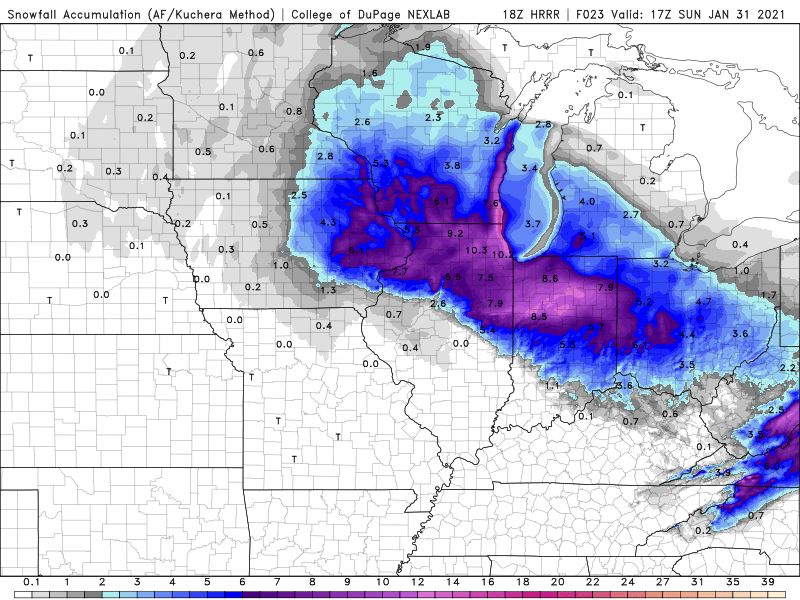
18z HRRR Kuchera snow map ending at 11 am Sunday. Disregard the lake enhancement part since it'll likely not verify.
-
18z RAP showing over 7 inches of cement for NE Illinois and almost 6 inches here.
-
Ah yes, you're referring to Feb 2017, right? That was a recordbreaking stretch of warm weather with extremely rare 70s in CR.
-
Let me guess, that glacier won't melt until late April?
-
Both the NAMs have the changeover to snow 2 hours later. Cuts the totals even more.
-
0z HRRR says areas south of I-80 in NE Illinois gets 9-10 inches of cement based off of the kuchera ratio, whereas areas north of I-80 have a slightly drier snow. That's going to cause some damage. At least for here the 0z HRRR shows just under 4 inches of cement via kuchera ratio. I'd gladly take 4 inches of extremely wet snow over 10 inches of extremely wet snow because I like having the power on.
-
What's CRAS? Never heard of CRAS.
-
Well the good news for here is that when the freezing rain starts, it'll already be 31F, thus limiting accretion. 21z RAP has CR going above freezing at 4 PM before switching to cement snow at 7 PM.
-
At least temps will be very marginal (lower 30s) so that we won't get any notable ice accretion.
-
From DVN: GIVEN THE ABOVE SCENARIO THERE IS A SIGNIFICANT CONCERN. THE 925-850 MB WINDS ARE AVERAGING 30-40 KTS WHICH IS BRINGING A FREIGHT TRAIN OF MOISTURE INTO THE AREA. THE CONCERN IS THAT THE WARM LAYER ALOFT WILL BE PUSHED FURTHER NORTH THAN WHAT THE MODELS ARE INDICATING. IF THIS OCCURS THEN ICE AMOUNTS WOULD BE HIGHER AND SNOW AMOUNTS LOWER. THIS SITUATION WILL NEED TO BE WATCHED CAREFULLY WITH BOTH MODEL AND REAL DATA OVER THE NEXT 12-18 HOURS.
-
DMX thinks that parts of central Iowa could get up to two tenths of a inch of ice accretion. That combined with the winds could cause power problems.
-
According to the NWS forecast, CR only forecast to get 2-4 inches of snow on top of a tenth of an inch of ice.
-
Not as quite as a paste job as in Iowa since temps hold 3-4 degrees below freezing for NE Illinois.
-
Yikes! NAM 3k doesn't even give CR 2.5 inches. The NAM 12k is a bit better but just below 4 inches. I hope the HRRR verifies unless the 0z run shows CR in cold rain for a few hours. Going to lower my call by an half an inch to 5.5 inches if the HRRR is to be believed.
-
I saw. Both the NAM 12k and NAM 3k puts CR above 32F changing the ZR to plain rain before changing to snow at 6-7 PM. Likely going to be a 6:1 ratio snow.
-
At least we aren't getting a foot of 7:1 ratio snow. That much wet snow is enough to collapse flat roofs and cause major tree and power line damage.
-
HRRR 18z Kuchera ratio gives CR 5.4 inches. Still has changeover from sleet to snow at 6 pm Saturday.
-
Just a FWIW, HREF FRAM 24 totals have widespread .10 ice accretion in Iowa and Illinois.
-
Yeah, you're possibly right since this is a wet sticky snow.
-
15z RAP gives CR 7.2 inches of cement on Saturday evening. Also winds are somewhat weaker as shown on the NAM 3k.
-
Still sticking to my call of 6 inches although it might need to be lowered by an inch if the models keep cutting forecast totals. However, if CR does indeed get 6 or more inches of snow with this very wet consistency, it's going to be detrimental to the trees, especially with the wind gusts. HRRR and NAM have temps flirting at freezing during the bulk of the snow.
-
Off topic, but are you going to update your signature to account for the snow from this past Monday?


