Natester
-
Posts
1,223 -
Joined
-
Last visited
Content Type
Profiles
Blogs
Forums
American Weather
Media Demo
Store
Gallery
Everything posted by Natester
-
The chance of siggy ice here is decreasing although siggy ice would be really bad here because: 1. gusty winds of 35 mph 2. weakened and damaged trees from the derecho over 4.5 months ago. If we do get any siggy ice, I doubt the power outages will be as long lasting as from the derecho.
-
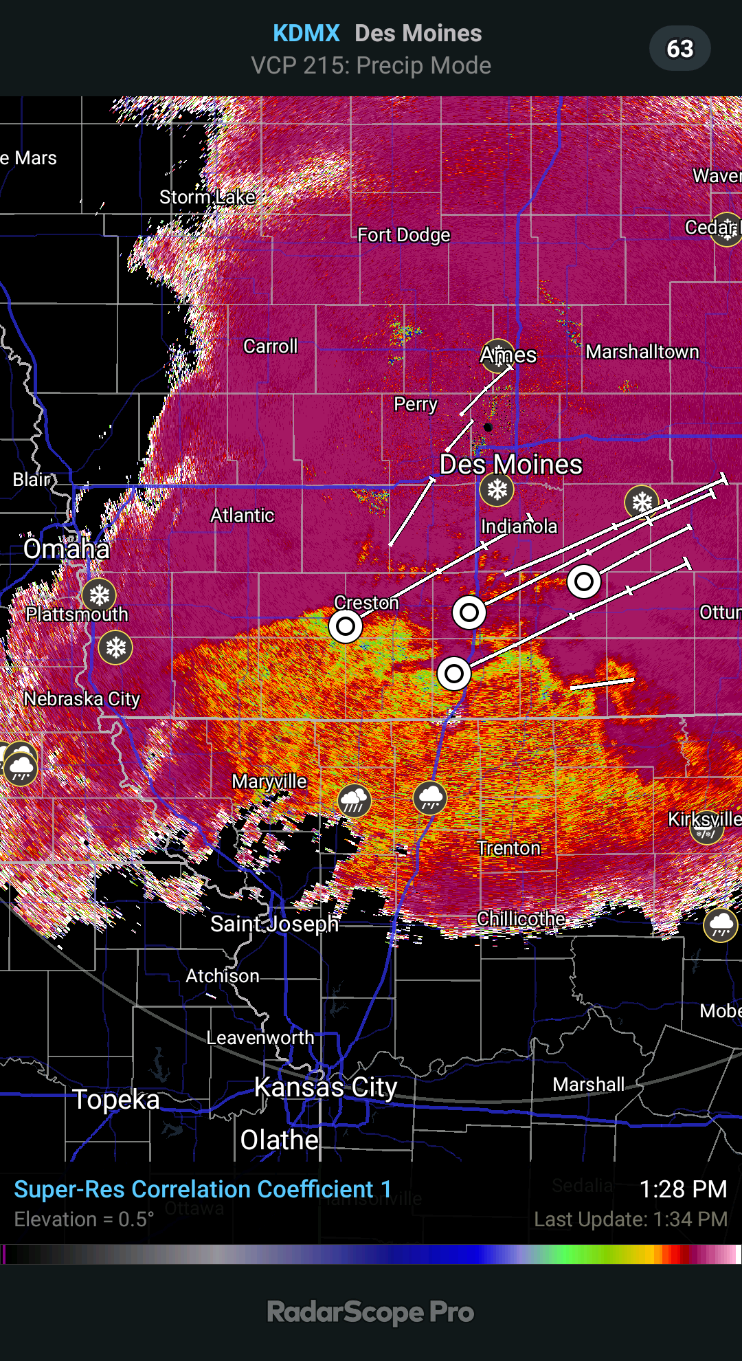
12z NAM 12k came in slower, has the freezing rain arriving in Cedar Rapids after noon on Friday.
-
I saw one guy getting stuck in the snow covered street desperately trying to get out (he succeeded after 10 minutes of struggling) and I just heard another vehicle getting stuck in snow. Must be around 4 inches of snow on the street.
-
Last time we had a major December snow with accumulations over 8 inches was back on December 24, 2010.
-
One last narrow band of heavy snow incoming based on radar although it might be mixed with sleet before the show ends here.
-
Yes it has. The show here will be totally over in a couple hours from now when all the models had the show end after midnight.
-
Wouldn't be surprised if we stayed all snow here like the HRRR has depicted based on trends on radar trends, although wouldn't rule out some sleet here.
-
Oh, well it's ahead of the HRRR by about 90 minutes. Hopefully this isn't a repeat of 2/11/19.
-
Sleet boundary slowly surging north right on cue according to the NAM.
-
12z euro shifted SE for wave 2, just like the UKMET.
-
Not quite sure to toss it just yet since we all know what happened on 2/11/19. All the models severely underdid the WAA and as a result southeast Iowa and much of northern Illinois got a major ice storm instead of several inches of snow. Just my take on it. In other news, 12z UKMET has wave two southeast of 0z and slower.
-
WRF_NSSL has us in ZR for 3.5 hours tomorrow night. More time in ZR than both the NAM 12k and the NAM 3k.
-
Freezing rain band in 0z NAM 12k not as thick as in the 18z, which is good. Should translate to 3 hours of ZR.
-
FWIW 18z NAVGEM came in slower and weaker with wave 2. Low doesn't go below 1000 mb.
-
January 17? Also, 18z ICON east of 12z (for wave 2), not as scary of a run but still puts eastern Iowa in ice for 6-7 hours. Winds won't be too bad.
-
Hour 84 of the NAM 12k has a huge swath of freezing rain with temps at 29-31F.
-
Well on the bright side the wind gusts depicted on the euro aren't too bad. 25-30 mph wind gusts. Not the 40-45 mph gusts depicted by the GFS.
-
True although it's not fun sleeping in a cold house with room temps in the 50s. But I'm sure that beats sleeping with room temps in the 80s as happened during the 9 day power outage caused by the derecho.
-
Welp, something to look forward to is 6 hours of ZR with gusty winds on Friday. Definitely going to cause power troubles but hopefully not as bad as the derecho. Operational GFS has 6 hours of ZR with temps at 30-31F with wind gusts up to 45 mph. Could definitely get about a quarter inch of ice from wave 2.
-
Anyone with access to the 18z Euro, what does it show? That is if the run is in progress. ICON is the furthest west and spells monster ice storm for multiple states.
-
18z GFS came in slower and has the low tracking through NW Iowa.
-
18z NAM at hour 84 looks almost exactly like hour 90 of the euro. Judging by the low placement at hour 84, the NAM might take the low through central Iowa in future runs.
-
0245 PM SNOW 3 E CEDAR RAPIDS 41.97N 91.61W 10/19/2020 M5.0 INCH LINN IA BROADCAST MEDIA I got about 4.5 inches on the back porch. All of this will melt tomorrow.
-
All the personal weather stations in Cedar Rapids show temps below 32F which means that the snow isn't as wet as if the temp were, say, 33F or 34F. I wouldn't be surprised if Cedar Rapids saw 5+ inches of snow from this band.
-
This video was uploaded on August 17, taken possibly at Lindale in Cedar Rapids. Highlight of this video is the husband is very calm while the wife is freaking out.