

Natester
-
Posts
1,223 -
Joined
-
Last visited
Content Type
Profiles
Blogs
Forums
American Weather
Media Demo
Store
Gallery
Everything posted by Natester
-
18z HRRR waaaaay too far north with the warm temps and way too fast with the lead low. Has the warm front along I-80 in Iowa. We'll see what the NAM says.
-
RAP way too fast with the lead low. Yeah, not going to happen.
-
I wouldn't be surprised to see the NAM/RAP/HRRR go south in future runs. Hopefully still has Cedar Rapids barely above freezing for most of the event.
-
Also a touch north.
-
0z NAM 12k has the main precip missing much of eastern Iowa. Has a brief period of freezing rain early Thursday morning with temps at 31-32F. A lot could change from here on out though. Also, we do have a generator, but with the wind on Thursday and if the power goes out, the house will get potentially dangerously cold. That's why I'm dreading the worst case scenario. Hoping for not much ice here.
-
I'm hoping that the temp is right around 31F to 32F if it doesn't get above freezing on Wednesday since at those marginal temps the ice mostly just runs off. I've seen it happen multiple times when temps were at 31F to 32F with hardly any ice accretion on trees and power lines.
-
As much as this winter has been boring (except the Christmas blizzard), tomorrow is looking like the biggest snowfall in Cedar Rapids so far this season.
-

Pre-Christmas (Dec 21-23rd) Winter Storm Part 2
Natester replied to Chicago Storm's topic in Lakes/Ohio Valley
One thing I'm definitely not looking forward to is the wind making my room very cold. The prolonged winds are going to send my bedroom room temp to the lower 50s or lower since the A/C is in the window facing northwest. Space heater will be running tomorrow and Friday when I'm awake. Anyways, anticipating 4-5 inches of snow here. -
Pre-Christmas (Dec 21-23rd) Winter Storm
Natester replied to Chicago Storm's topic in Lakes/Ohio Valley
0z ICON east of 18z. -
Pre-Christmas (Dec 21-23rd) Winter Storm
Natester replied to Chicago Storm's topic in Lakes/Ohio Valley
Big shift east on the 12z GFS. -
KCID already at 94F. Iowa City at 95F. Temps overperforming.
-
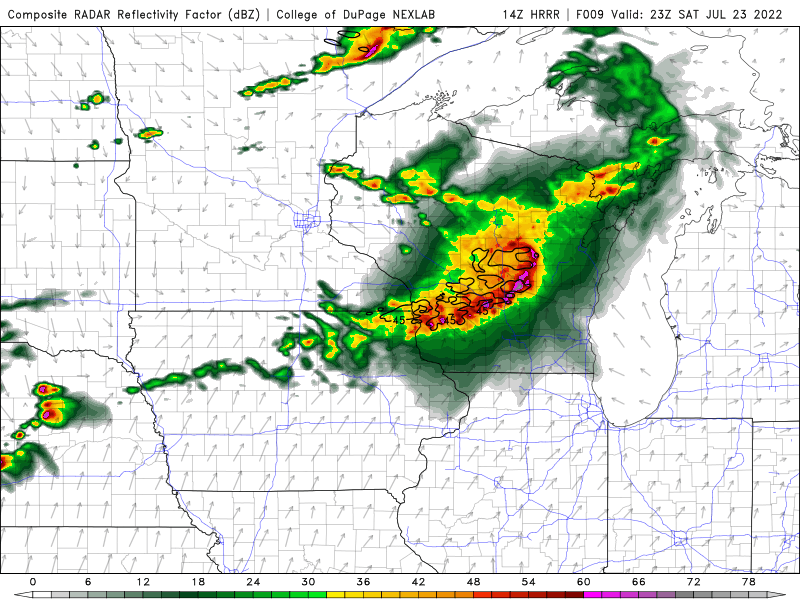
Madwx and CheeselandSkies going to get rocked according to the 14z HRRR.
-
Thundersleet here. Very little freezing rain. Temp at 25F.
-
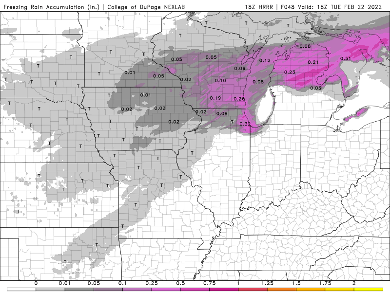
18z HRRR freezing rain accumulation.
-
0z RGEM alot drier for the Tuesday part of the system.
-
That is alot more ice than what Weathernerds was showing. Would be catastrophic for the power grid if that verifies, especially with the 35-40 mph wind gusts Tuesday afternoon. Good news here is that the euro and the UKMET have Cedar Rapids above freezing when the main show starts.
-
DVN AFD mentions possible ice storm on Tuesday. TUESDAY COULD BE MESSY, WITH A SCENARIO OF FREEZING RAIN AND RAIN CHANGING OVER TO SLEET AND THEN SNOW IN THE NORTHWEST. WITH THE SFC LOW, UPPER TROF MIGRATION AND POSSIBLE IN-WRAPPING DRY SLOT, MOST OF THE PRECIP WILL BE MOVING OUT TO THE NORTH/NORTHEAST BY TUE EVENING. CURRENT PROJECTIONS ARE THAT MOST OF THE DVN CWA MAY GET A RANGE OF 0.05 TO 0.18 INCH OF ICE, ALONG WITH SOME LIGHT SLEET ACCUMS AND UP TO A HALF INCH OF SNOW IN THE NORTHWESTERN CWA. BUT WILL HAVE TO WATCH IF THE WETTER AND MORE DEVELOPED/DEEPER SFC LOW MODELS VERIFY THAT WOULD PRODUCE HIGH ICE AMOUNTS, AND POSSIBLY QUICKER TOP-DOWN DYNAMICAL COOLING FOR HIGHER SNOW AMOUNTS TUE AFTERNOON ALONG AND NORTHWEST OF A IOWA CITY TO WEST OF DUBUQUE LINE. THE WETTER ECMWF EVEN IF IT HOLDS ON RAIN LONGER, MAY PRODUCE OVER A HALF INCH OF RAINFALL IN SPOTS ON FROZEN GROUND PRODUCING PONDING AND RUN-OFF. THE EURO WOULD ALSO PRODUCE A LOCALIZED SWATH OF HIGHER ICE AMOUNTS OF ICE STORM WARNING CRITERIA GENERALLY WEST OF A DUBUQUE TO ANAMOSA IA LINE. TUESDAY HIGH TEMPS A CHALLENGE WITH CLOUDS, PRECIP AND BOUNDARY MOVEMENT ALL AFFECTING VALUES, RANGES COULD BE FROM THE 20S NORTHWEST TO THE MID 40S SOUTHEAST.
-
12z Euro has a siggy ice storm in a band from NE Iowa through southern Wisconsin and northern Michigan.
-
Well, if there's one thing, this doesn't look to be a significant ice storm for my neck of the woods.
-
Just as the HRRR depicted, the showers here have begun. However, instead of freezing rain, it's all sleet (I just checked outside), which is good because I hate ice.
-
Poor alek gets the shaft.
-
FV3 southeast of 12z in terms of the band of precip tomorrow.
-
0z HRRR soundings has freezing rain when the column barely breaches 0C above 850 mb. Loss of ice?
-
GFS still north of the NAM.
-
All that's left to come south is the GFS but chances are that the GFS will be stubborn.

