

snywx
-
Posts
10,049 -
Joined
-
Last visited
Content Type
Profiles
Blogs
Forums
American Weather
Media Demo
Store
Gallery
Posts posted by snywx
-
-
-
-
Just now, HeadInTheClouds said:
It's not a wobble. It's a cave. GFS was stingy with QPF inland for the entire event giving my area .1 or so qpf for days while nearly every other model in particular the mesos were giving significantly more. GFS just doing what it does.
3-5" incoming for the I-84 corridor.
-
 4
4
-
-
20 hours ago, IrishRob17 said:
FWIW, the HRRR did a decent job IMO, at least in my neck of the woods, with the winds. It consistently showed that the windier part of the storm would be this afternoon around here.
My strongest winds were after the storm as well
-
1
-
-
9 hours ago, Juliancolton said:
Any snow left at the end of the day? Just a few piles here.
About 1” or so.. plenty of bare spots
-
3 minutes ago, Stormlover74 said:
Still quite gusty out there. Was smart to keep the advisories out til this evening
Getting stronger gust now than I did for the entire event
-
1
-
-
35 minutes ago, IrishRob17 said:
I've received well over 20 texts now from 511/NYSDOT for various road closures due to flooding and/or debris, most are cleared now, but the delays have to be tied to that although I agree it does seem to be a bit overly cautious.
Interesting.. I was just on the road and everything seemed to be operating as normal. Only thing I can think of is teachers who live in effected areas may be having trouble coming in
-
1
-
-
So the kids have a 2 hr delay from some rain in january lol.. Gotta love it. Snowpack is still quite healthy here
Temp 41°
-
1
-
-
36 minutes ago, MJO812 said:
Ensembles are way weaker so this storm isn't set in stone yet.
6z GFS caught on to idea of a coastal
-
2
-
-
3 minutes ago, BxEngine said:
That line developed just to your southwest, even parts of rockland only had 15-20 mph gusts but the southeastern section looks like 40s in poorly placed weather stations.
harriman state park got crushed, water rescues at anthony wayne.
finished with 3.2” here looks like.
Looks like we maintained a good amount of snowpack as well. Temp never got above 44°. Just to my SW its in the mid 50s. The kids do have a 2 hr delay tho
-
2
-
-
2.45" of rain here
Not much wind to speak of
Highest wind gust was 20mph
-
1
-
-
1” of new snow here
It’s gonna get real nasty tonight
-
1
-
-
Final here is 13.2”
That band last night produced 3-4” rates. Incredible
-
2
-
-
32 w/ moderate snow
snow growth is excellent right now
picked up 1” with the second wave
13.2” so far for the event
-
1
-
-
31 here
snow picking up in intensity again
-
3
-
-
31 here
Snow picking up in intensity
-
2
-
-
000
NOUS41 KOKX 071303
PNSOKX
CTZ005>012-NJZ002-004-006-103>108-NYZ067>075-078>081-176>179-080103-

Public Information Statement
National Weather Service New York NY
803 AM EST Sun Jan 7 2024

...LATEST SNOWFALL REPORTS...

Location                     Amount    Time/Date       Provider

...Connecticut...

...Fairfield County...
4 SSE Sherman                6.0 in    0701 AM 01/07   Trained Spotter
Greenwich                    4.5 in    1200 AM 01/07   Public
Redding                      4.0 in    1209 AM 01/07   Public
Ridgefield 2.4 NNE           3.9 in    0700 AM 01/07   COCORAHS
Stamford                     3.5 in    1022 PM 01/06   Public
2 S New Canaan               3.0 in    0850 PM 01/06   Public
1 SE Wilton                  3.0 in    1016 PM 01/06   Public
1 NNW Rowayton               3.0 in    1138 PM 01/06   COCORAHS
Bridgeport Airport           3.0 in    0700 AM 01/07   Official NWS Obs
Norwalk                      3.0 in    0700 AM 01/07   COCORAHS
Norwalk                      2.8 in    1100 PM 01/06   Public
Bethel                       2.5 in    0620 AM 01/07   Emergency Mngr
3 E Easton                   2.4 in    1140 PM 01/06   Public
3 WSW Shelton                2.1 in    0710 AM 01/07   Trained Spotter
Stratford                    2.0 in    0600 AM 01/07   COCORAHS
Newtown 5.3 S                1.9 in    0700 AM 01/07   COCORAHS
Stratford                    1.8 in    1028 PM 01/06   Trained Spotter
Ridgefield                   1.8 in    0630 AM 01/07   COCORAHS
Newtown                      1.3 in    1045 PM 01/06   Public
Trumbull 2.6 SSE             1.3 in    0730 AM 01/07   COCORAHS

...Middlesex County...
Durham                       3.2 in    0700 AM 01/07   COCORAHS
Middlefield 1.4 W            2.5 in    0600 AM 01/07   COCORAHS
Moodus 0.7 SSW               1.7 in    0700 AM 01/07   COCORAHS
Westbrook                    0.8 in    0742 AM 01/07   Trained Spotter
Westbrook                    0.5 in    0942 PM 01/06   Trained Spotter

...New Haven County...
1 E North Haven              3.0 in    1215 AM 01/07   Trained Spotter
Naugatuck                    3.0 in    0700 AM 01/07   COCORAHS
Guilford                     2.5 in    0645 AM 01/07   CO-OP Observer
Seymour 1.2 WSW              2.5 in    0700 AM 01/07   COCORAHS
Wallingford                  2.0 in    1200 AM 01/07   Trained Spotter
Milford                      1.2 in    0910 PM 01/06   Public
Madison                      0.7 in    0700 AM 01/07   Public
Meriden                      0.5 in    0915 PM 01/06   Trained Spotter
East Haven                   0.3 in    0915 PM 01/06   Trained Spotter

...New London County...
Norwich                      2.7 in    0600 AM 01/07   COCORAHS
Norwich                      2.0 in    0700 AM 01/07   COOP
Waterford                    0.8 in    0700 AM 01/07   COCORAHS
Preston                      0.7 in    0730 AM 01/07   COCORAHS
Niantic                      0.5 in    0600 AM 01/07   COCORAHS
Uncasville                   0.5 in    0700 AM 01/07   COCORAHS
Niantic                      0.3 in    0915 PM 01/06   Trained Spotter
Old Lyme                     0.3 in    0700 AM 01/07   COCORAHS

...New Jersey...

...Bergen County...
1 N Franklin Lakes           5.7 in    1030 PM 01/06   Trained Spotter
Franklin Lakes               4.0 in    0815 PM 01/06   Trained Spotter
Glen Rock                    4.0 in    0934 PM 01/06   Trained Spotter
Ridgewood                    3.7 in    1123 PM 01/06   Public
Fair Lawn                    3.4 in    1000 PM 01/06   Trained Spotter
Westwood                     2.8 in    0830 PM 01/06   Trained Spotter
River Vale                   2.8 in    0900 PM 01/06   Trained Spotter
Bergenfield                  1.0 in    0725 PM 01/06   Trained Spotter
East Rutherford              0.5 in    0800 PM 01/06   Trained Spotter

...Essex County...
North Caldwell               4.4 in    0535 AM 01/07   Public
Livingston                   3.6 in    1000 PM 01/06   Public
West Orange                  3.5 in    1130 PM 01/06   Public

...Hudson County...
Harrison                     1.0 in    0700 AM 01/07   COOP

...Passaic County...
Totowa                       5.0 in    0150 AM 01/07   Public
Wayne                        3.8 in    0730 AM 01/07   Trained Spotter

...Union County...
Plainfield                   2.2 in    0820 PM 01/06   Trained Spotter
New Providence               1.7 in    0815 PM 01/06   Public
Linden                       0.7 in    0630 PM 01/06   Public
Newark Airport               0.4 in    0700 AM 01/07   Official NWS Obs

...New York...

...Nassau County...
Manhasset Hills              0.5 in    0736 PM 01/06   COCORAHS
Plainview                    0.3 in    0847 PM 01/06   Public

...New York (Manhattan) County...
Central Park                 0.2 in    0700 AM 01/07   Official NWS Obs

...Orange County...
2 SE Port Jervis             13.1 in   0630 AM 01/07   COCORAHS
3 NNE Unionville             12.4 in   1253 AM 01/07   Public
Middletown                   11.8 in   1215 AM 01/07   Fire Dept/Rescue
Montgomery                   11.0 in   1130 PM 01/06   Public
3 SSW Pine Bush              9.5 in    1201 AM 01/07   Public
Salisbury Mills              9.2 in    0500 AM 01/07   Trained Spotter
Newburgh                     9.0 in    1125 PM 01/06   Public
2 SSW Stewart Airport        9.0 in    1205 AM 01/07   Public
1 WNW Monroe                 8.0 in    1230 AM 01/07   Trained Spotter
2 E Highland Mills           7.5 in    1212 AM 01/07   Public
Warwick                      7.0 in    1030 PM 01/06   Public
Chester                      5.5 in    1015 PM 01/06   COCORAHS
Highland Mills               4.8 in    1026 PM 01/06   Public
Firthcliffe                  2.9 in    0954 PM 01/06   Public
West Point                   2.5 in    0940 PM 01/06   Trained Spotter

...Putnam County...
Cold Spring                  6.5 in    0700 AM 01/07   COCORAHS
Nelsonville 0.3 S            6.0 in    0700 AM 01/07   COCORAHS
Cold Spring                  6.0 in    0700 AM 01/07   Cocorahs

...Queens County...
NYC/La Guardia               0.3 in    0700 AM 01/07   Official NWS Obs
Little Neck 0.3 SE           0.3 in    0700 AM 01/07   COCORAHS
NYC/JFK                      0.1 in    0700 AM 01/07   Official NWS Obs
Howard Beach                  T in     0700 AM 01/07   COCORAHS

...Richmond County...
Westerleigh                  0.2 in    0545 PM 01/06   Public

...Rockland County...
Stony Point                  4.0 in    0700 AM 01/07   COCORAHS
Blauvelt                     3.5 in    0922 PM 01/06   Public
New City                     3.0 in    1135 PM 01/06   Trained Spotter
2 W Buchanan                 3.0 in    0720 AM 01/07   Public

...Suffolk County...
Commack 1.3 SW               0.4 in    0700 AM 01/07   COCORAHS
Commack                      0.3 in    0800 PM 01/06   Public
Ridge                         T in     1159 PM 01/06   COCORAHS
Upton                         T in     0700 AM 01/07   Official NWS Obs
Islip Airport                 T in     0700 AM 01/07   Official NWS Obs
Orient Point                  T in     0700 AM 01/07   COOP

...Westchester County...
Shrub Oak                    4.0 in    0600 AM 01/07   COOP
2 WNW Jefferson Valley       4.0 in    0600 AM 01/07   CO-OP Observer
Hartsdale                    3.5 in    1040 PM 01/06   Trained Spotter
Croton-on-Hudson             2.9 in    0945 PM 01/06   Public
White Plains                 2.8 in    1037 PM 01/06   Trained Spotter
Ossining                     2.5 in    0845 PM 01/06   Public
&&
-
1
-
-
12 minutes ago, IrishRob17 said:
And people mocked that 9" report in Jersey last night, all you had to do was look at that band on radar, confirmed to be snow by the mPING reports. 14" here with light snow on going.
Some of the heaviest snow I've ever seen. Dropped 9" in just over 2 hrs.
12.2" otg here
-
5
-
-
7 minutes ago, LibertyBell said:
wow 12-18 right near the Delaware Water Gap, along I-80 from there to the Poconos exits near and beyond I-81.
and snow has redeveloped in NE PA so more could accumulate.
It stretches from NE PA through extreme NW NJ into Orange county & Dutchess county
-
2
-
-
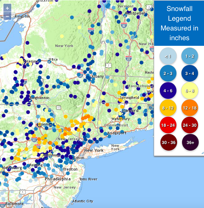
You can see where the band set up last night..
10-15" in the band
-
3
-
-
29° w/ lgt snow
12.2" otg
expecting an additional 2-3" today
-
3
-
-
27° w/ lgt snow
12" otg
-
6
-
-
7 minutes ago, CPcantmeasuresnow said:
Holy sh!t. Wow
That was impressive! 9" in just over 2 hrs
-
1
-
-
6 minutes ago, HeadInTheClouds said:
And you were worried.
Didn't expect 9" in 2.5 hrs lol
-
 2
2
-
Potential extensive winter event, I-95 west and with again a chance for NYC first inch(es) of snow Mon or more likely Tue Jan 16, 2024 (serves as OBS thread as well)
in New York City Metro
Posted
I think 4-5" is a good call up here. Ratios up here are gonna be 15-20:1