

snywx
-
Posts
10,049 -
Joined
-
Last visited
Content Type
Profiles
Blogs
Forums
American Weather
Media Demo
Store
Gallery
Posts posted by snywx
-
-
13 minutes ago, hudsonvalley21 said:
18z NAM held ground from the 12z run
Storm king should do well
-
 1
1
-
-
19 minutes ago, wdrag said:
So far, the HRRR continues on its path of rain to snow I78 by 12z Sunday...so far. Am not guaranteeing but its still an option, especially since it like the Canadian suite tend to run slightly warm and amped.
I’m roughly 800’ sitting about a mile N of 84. Only expecting 1-2” here. I think it will snow most of the event here but that boundary layer is gonna be a problem. I can see areas above 1200’ with a modest 4-6” snowfall. Towns like cragsmoor which sit at 2200’ on the shawangunk ridge should cash in
-
3
-
-
29 minutes ago, wdrag said:
Still a lot of confusion on what to believe, but the EC and EPS from 18z/25 have struck down the north idea, are much faster with change to wet snow and definitely fit the thread outlined. Whether we can muster any accum NYC/LI is very uncertain- but I think the I84 corridor is the place to be...terrain above 1000 feet. Basically the EPS/EC has smoothed out its messy 12z op cycle and says much faster for change to 32-33F wet snow, with melting on pavement during the daylight hours but a problem hazardous event at times. Going to need a hazard advisory of some sort. We're only 48-60 hours from starting. Also 4+ at 32-33F could initiate a few isolated power outages by 11PM Sunday within 15 miles of I84 and terrain above 1000 feet.
18z GFS had warning level snows for much of the 84 corridor as well.
-
1
-
 1
1
-
-
25 minutes ago, the_other_guy said:
287 Special!! Yoo hoo
Should we put the snow tires on the horse & carriage ?
-
1
-
 2
2
-
-
31° snow/sleet mix
Secondary roads are very slick
-
14 minutes ago, HeadInTheClouds said:
Made it down to 4 last night, now 19. Some ice/snow in the forecast Tuesday/Tuesday night here north of I84, maybe an inch.
Yeap tomorrow/tomorrow night is looking wintry for those along & N of 84. 1-2” of snow/sleet with a bit of ice
-
2
-
-
16 for a low here
-
33 minutes ago, wdrag said:
Probably.. our dewpoint right now at 630P iOS still 19 so may wring out some more snow. Had a pretty good rate of fluff accum 430-6P. Now at 2.5" It is beautiful here.
I saw some CP pix on TV and 0.1 is incorrect in CP. My take is that there was at least 0.5" in CP based on what I saw... maybe more. I saw the .04 w.e at CP and 0.1" snowfall in the 4P CLI. Something isn't right with a max of 32 at CP.
Still have some lgt snow falling here..
Nice all day snow
-
2
-
-
1.8" here
19.8" so far this season. Slightly below average ytd
-
1
-
-
A surprising 1.8" here
very lgt snow continues
-
1
-
-
very lgt snow continues here
1.2" otg
Stuck to all surfaces. More than I expected
-
22 w/ steady light snow
1” otg
More than I already expected up here
-
2
-
-
9 minutes ago, IrishRob17 said:
I just ran my numbers, I may have missed a very small event for this month, I'll have to check my January 2024 sheet when I get home and I used a half inch estimate for today so far. With all that in mind, I'm at 17.5" for the season right now. Going by the 30 year NWS averages for KMGJ the seasonal average for today is 17.1" and using my own records going back to 2005 my average to date is 17.4" so I'm ever so slightly above normal to date.
What is the NWS average for your location? I believe im right around 50" but my 22 yr running average is 54.1"
-
-
23 minutes ago, crossbowftw3 said:
21/16
Snowing at a pretty decent clip, point and click never changed from the 1-3” I’d figured I would always see from this. Given the warmup incoming, probably going into February with around 15-20” for the season to this point. Going to need one heck of a February to meet average (66”) for this season at MSV, that’s for sure
21 here w/lgt snow as well.
0.5” otg
we have 18” ytd going into today. I would say we are about 75% of normal so far for the season. Won’t take much to get us back on track
-
15 here right now
-
1
-
-
1 hour ago, LibertyBell said:
the 2-3 inch totals are uniform across the area which is interesting in a changeover event!
We never changed over up here. Just lack of precip
-
2
-
-
-
Just now, HVSnowLover said:
I don't want to complain about a snow/frozen event but this storm has been meh. The snow rates were putrid and now it's slush with some icing.
Beautiful wintry day..
Temps in the lows 20s, 2-3" of snow outside & steady lgt snow throughout the day.
Its pretty much going as expected
-
1
-
-
1 hour ago, crossbowftw3 said:
Looks to be around 2-3” thus far and into heavier returns before this event starts to draw to a close this afternoon. Very good storm for setting the wintry mood while this cold stays around
22° w/ lgt snow
2.4" otg
Nice wintry day
-
1
-
-
21° w/ very lgt snow falling
2.4" otg
Gonna come up short of the 4-5" forecasted up this way
-
1
-
-
-
-

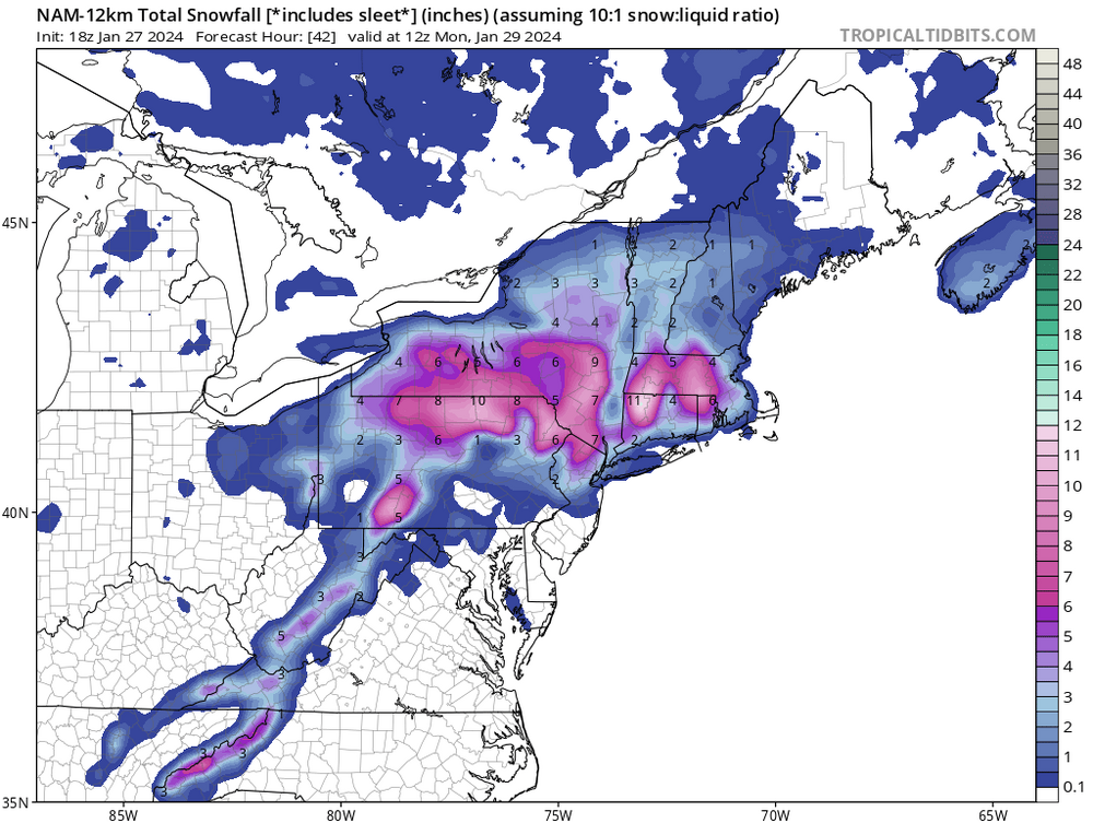
Sunday 1/28-midday Monday 29/2024 snowfall and OBS most of the NYC subforum including potential 1/2-2" NYC-LI-heavier toward I84.
in New York City Metro
Posted
Yeah 1-2” is a good call for those in the 84 corridor. Anyone over 1000’ should see Atleast advisory level snows. I would think to see those 6”+ amounts you are gonna have to be above 1500’