

jbcmh81
-
Posts
8,188 -
Joined
-
Last visited
Content Type
Profiles
Blogs
Forums
American Weather
Media Demo
Store
Gallery
Posts posted by jbcmh81
-
-
Keep this handy just in case.

-
 1
1
-
-
1 hour ago, snowlover2 said:
Back big time on the 12z GFS.

Oh look, a 70/71 rider. Haven't seen that before.
-
1
-
-
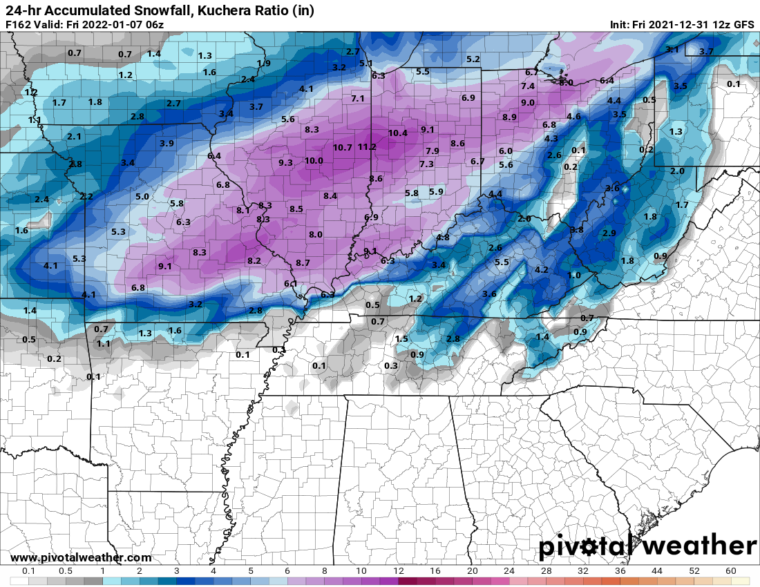
Here's 84-85
December High Low Mean Dept Precip Snowfall Depth 1 46 34 40 2 Trace 0 0 2 49 29 39 1 Trace 0 0 3 48 26 37 0 0.13 0 0 4 32 19 26 -12 0 0 0 5 30 15 23 -14 0.28 5.7 0 6 26 10 18 -18 0.1 1.6 6 7 20 6 13 -23 Trace Trace 6 8 38 19 29 -7 0 0 5 9 44 17 31 -5 0 0 3 10 44 38 41 6 0.38 0 1 11 41 37 39 5 Trace 0 Trace 12 59 38 49 14 0.08 0 0 13 59 41 50 16 0.35 0 0 14 63 42 53 19 0.11 0 0 15 55 48 52 18 0 0 0 16 64 48 56 23 0 0 0 17 67 46 57 24 Trace 0 0 18 57 32 45 12 0 0 0 19 47 34 41 8 0.16 0 0 20 40 32 36 4 0 0 0 21 59 36 48 16 0.43 Trace 0 22 55 28 42 10 0 0 0 23 45 22 34 2 0 0 0 24 47 25 36 5 Trace Trace 0 25 26 15 21 -11 Trace Trace 0 26 36 17 27 -4 Trace Trace 0 27 56 35 46 15 0 0 0 28 68 53 61 30 0.03 0 0 29 64 50 57 27 0.46 0 0 30 50 33 42 11 0.28 0 0 31 53 35 44 14 0.05 0 0 Avg 48 31 39.5 6 2.84 7.3 0.7 January High Low Mean Dept Precip Snowfall Depth 1 65 33 49 21 0.09 0 0 2 34 30 32 4 0.01 Trace 0 3 34 26 30 3 0 0 0 4 36 28 32 5 Trace 0 0 5 40 30 35 8 Trace Trace 0 6 34 29 32 5 0 0 0 7 35 31 33 6 0.13 1.4 1 8 32 13 23 -4 0.03 0.4 1 9 21 7 14 -13 0 0 1 10 27 19 23 -4 0.18 4.9 2 11 24 14 19 -7 0.01 0.3 5 12 20 12 16 -10 Trace Trace 5 13 29 13 21 -5 0 0 5 14 30 19 25 -1 0.08 1.6 4 15 20 8 14 -12 0.01 0.3 5 16 22 4 13 -13 0.04 0.5 4 17 32 20 26 0 0.17 1.9 6 18 33 20 27 1 0.2 3.1 6 19 27 -5 11 -15 Trace Trace 9 20 -5 -19 -12 -38 Trace 0.2 8 21 11 -16 -3 -29 0.02 0.6 8 22 21 11 16 -10 0.02 0.7 8 23 28 17 23 -3 Trace Trace 8 24 30 25 28 2 0.06 1 8 25 30 14 22 -4 0.14 3.7 8 26 18 5 12 -14 Trace Trace 10 27 28 12 20 -6 0 0 9 28 27 22 25 -1 Trace Trace 7 29 24 14 19 -7 Trace Trace 6 30 32 10 21 -5 Trace 0.1 5 31 34 25 30 4 0.12 1.2 5 Avg 28.2 15.2 21.7 -4.6 1.31 21.9 4.6
February High Low Mean Dept Precip Snowfall Depth 1 25 11 18 -12 0.04 1 5 2 14 2 8 -22 0.07 2.4 6 3 15 -10 3 -28 0 0 8 4 25 -9 8 -23 0 0 8 5 33 19 26 -5 0.05 0.4 8 6 32 12 22 -9 0.02 0.3 7 7 16 7 12 -20 Trace Trace 7 8 19 1 10 -21 Trace Trace 7 9 24 -7 9 -23 0 0 7 10 31 5 18 -14 0.1 1.3 6 11 44 30 37 5 0.13 Trace 7 12 37 27 32 0 0.42 4.1 5 13 27 18 23 -10 0.2 2.5 11 14 23 14 19 -14 0.03 0.5 11 15 19 8 14 -19 Trace Trace 11 16 32 1 17 -16 0 0 11 17 39 23 31 -2 0 0 10 18 40 14 27 -6 Trace Trace 9 19 37 24 31 -3 Trace Trace 7 20 40 19 30 -4 0 0 6 21 49 25 37 3 0.05 0 5 22 49 42 46 11 0.42 0 2 23 66 46 56 21 Trace 0 Trace 24 62 39 51 16 0.14 0 0 25 40 33 37 1 0 0 0 26 48 35 42 6 0 0 0 27 42 28 35 -1 Trace 0 0 28 46 24 35 -1 0 0 0 Avg 34.8 17.2 26 -6.8 1.67 12.5 5.9 -
 1
1
-
-
35 minutes ago, pondo1000 said:
What happened in that winter here? I was on east coast at the time.
December '84 was very similar. Aside from a fluke storm at the beginning of the month, it was very warm and snowless. After the New Year, it got cold and it was wall to wall winter for the next 7 weeks.
-
2
-
-
2 hours ago, pondo1000 said:
12z GFS-snowstorm on the 7th, book it!!! LOL I am bored this winter so had to post something on this dead thread.
At least the pattern looks slightly more interesting after the first few days of the new year. Maybe it'll be a 1984-1985 situation.

-
1
-
-
There was never going to be a response that prevented the loss under the previous administration.
-
3
-
-
40 minutes ago, buckeye said:
I wonder if that was before midnight and the additional will show for today? Otherwise they are off their rocker

That was through 5am, so yeah...
-
17 minutes ago, buckeye said:
Like most others here in Ohio, looks like we got between 3 and 4 inches. Somewhat of a bust for local wx guys who called for .5-1"
Don't worry, the good folks at the airport made sure to only measure 1", the lowest total in all of Central Ohio- as is tradition.
-
2 hours ago, michsnowfreak said:
It is indeed a massive difference. Even Apr 15 to Apr 20 is a huge difference.
In 130 years of record (since 1891) Toledo has seen a 1"+ snowfall only 4 times on or after April 20.
4.0" Apr 23-24, 2005
4.0" May 9, 1923
2.0" Apr 21, 1922
1.3" May 6-7, 1989
In 140 years of record (since 1881) Detroit has seen a 1"+ snowfall only 8 times on or after April 20.
6.0" May 9, 1923
5.0" May 21-22, 1883
4.3" Apr 23-24, 2005
3.0" Apr 29, 1909
1.7" Apr 23-24, 1967
1.5" May 13, 1912
1.2" Apr 20, 1947
1.0" Apr 22, 1911
*Note. per newspaper reports Toledo saw 3" during the unprecedented May 21/22 1883 storm, but records did not yet exist.
Regarding the 1883 event, there were reports of 10" depths across the northern Miami Valley in Ohio the day after. Temperatures were at or slightly above freezing for most of it, so when you consider how much probably melted/compacted, some areas probably saw 15"-20" of snow from that. An insane event 10 days outside of June.
-
1
-
-
1 hour ago, jaf316 said:
I just want to see one solid, healthy, decent-sized snowmaker that we can all cash in on. This week marks 5 years I've lived in central OH, and I have yet to see a single 6+ incher imby.
Since 1884, Columbus has recorded 31 winters with at least 1 daily 6" snow event. That's about 1 every 4.4 years, so it's not particularly unusual to go 5 years without one. There hasn't been an official once in Columbus since the 2014-15 season, which is now 6 years. The longest the city has ever gone without recording a 6" daily snowfall was 1918-19 to 1946-47, 28 straight years.
However, if you expand it out to a 2-day event, which most storms actually are, the data changes somewhat to a much greater frequency. At that standard, you surpass 110 for a frequency about 1 every 2 years. However, there still hasn't been once since 2014-2015 and the longest period without one is 1921-22 to 1946-47, 25 years.
-
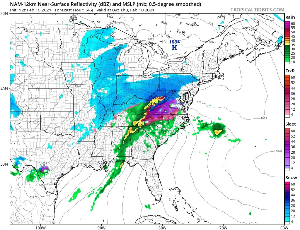
56 minutes ago, vespasian70 said:
Ah, c'mon... it looks pretty tasty.

Every winter, there was always that one storm that seemed like it was going to be good until the inevitable crash and burn. After those, I always kind of lost interest in tracking winter storms for the season unless it was actually snowing. This was that storm. If the Thursday storm happens, great, but I'm at the I'll-believe-it-when-I-see-it stage of winter.
Also, that NAM run barely gives anyone in Ohio anything, despite the look.
-
1
-
-
Just now, pondo1000 said:
NAM definitely scored a coupe with this one!
Not really. While it was the furthest NW and warmest, even it wasn't nearly warm enough and still showed far more snow for many areas.
-
2
-
-
The Columbus airport with predictably the lowest total- barely 2" of mostly sleet.
Not even going to follow the next storm.
-
1
-
-
Good thing Buckeye came back for the Big Dog!
-
3
-
-
3 minutes ago, dilly84 said:
Seen someone say sleet goes onto the snow totals, so I'd guess it will.
Does it? The airport was reporting only 0.5" through 5pm, and that presumably included the first wave. It was definitely sleeting long before 5pm.
-
Just now, Floydbuster said:
I'm a hurricane guy, winter is not my hobby. Can you explain in layman terms what is happening to allow such a bust in central Ohio? Too warm of air?
Everything came further NW so the warm push aloft was far worse than predicted.
-
I wonder if Columbus even officially reports an inch from both waves combined. Just an absolute historic bust.
-
1 minute ago, Gino27 said:
Also if anyone is looking into the Thursday system newest euro is totally squashed. Maybe the NW trend will benefit us for once.
At this point, no one should bother until it starts snowing.
-
I expected the worst, but I still thought the western 1/3 of the state would at least get decent snow.
-
Mountain Cams | Mad River Mountain Resort (skimadriver.com)
Snowing someplace at least.
-
3 minutes ago, buckeye said:
ILN will never issue a WSW again
Will go down as one of the all time worst. We'll be talking about this for years to come.
-
Epic bust if that happens.
-
20 minutes ago, buckeye said:
ALL TOGETHER NOW: it's colder....it's warmer...it's north...it's south...it's colder...it's warmer...it's north...it's south....we're fcked...we're good...we're fcked...we're good....

You guys gotta stop hanging on every meso run and panel.....storm's gonna do what storm's gonna do, especially when things are so close. Just enjoy watching it unfold....
Yeah, the run to run changes are very minor right now from what I'm seeing. The story is 71 is on the line. That's always the story.
-
1
-
-
I haven't compared the RGEM, but on the NAM Columbus is slightly better than 6z. Most of Franklin County seems to stay *just* outside of the mix, but then you get that weird dry slot it keeps showing. GFS is a hair SE, but it has a more expansive mix.
“Let’s Talk Winter”
in Lakes/Ohio Valley
Posted
Looking more like 1979-80 than 1984-85. December 1979 was warm and snowless, with January/February much colder, but the largest snow event was 3". Total snowfall for the season was 16.7" in Columbus. This season is now a full inch behind that year, and more than 9" below last year. Unless there's a drastic change in the pattern or a very lucky break, this could end up being one of the least snowy December-Januarys ever.
Of all the historically snowless winters of the past 25 years, just about all of them had more snow at this point.
1996-1997, 1997-1998, 2001-2002, 2005-2006, 2016-2017, 2019-2020. 2011-2012 came in very close, just 0.2" behind. So yeah, it's hard to see things turning around based on that.