Jump to content

jbcmh81

Members
  • Posts

    8,188
  • Joined

  • Last visited

Posts posted by jbcmh81

  1. 1 hour ago, pondo1000 said:

    Wow. Incredible how nickle & dimers add up! 

    November, January and February all had normal to above normal snow, even though it immediately melted each time it snowed. The fact that it’s been super wet and “cold enough” at times has allowed for it.  

  2. 36 minutes ago, wishforsnow said:

    Snowing very heavy here in Hancock. I can't hardly see the house down the street from me. Luckily, I went in earlier to work so I could get the hell out of there before the storm hit. Every nut and their uncle is in town for Tech winter carnival so there is a lot more traffic and more people to get me in a jam. 

    Hancock where?

  3. 9 minutes ago, iluvsnow said:

    Alright Buckeyes/ Hoosiers and those close by....after five days of inactivity in this forum....time to wake up and smell the snow again.....digital snow that is:

     fv3p_asnow_us_31.png

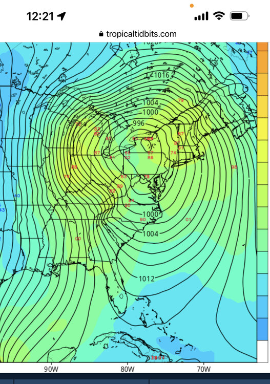
    Meanwhile, the GFS has maybe an inch in the next 10 days.  The main difference is a storm showing up for the 12-14th.  The GFS takes the main low into northern Michigan while the FV3 has it in north central North Carolina.  Only a small difference. :lightning: I guess the bright side is that both at least have some kind of storm. 

  4. 33 minutes ago, Angrysummons said:

    Talk about me be negative. I am just going to enjoy the thaw and the fact the colder, cross polar flow is gone. That much has been verified. After that looks more complex than we have had lately in terms of the general 500mb pattern. Much more pacific influence means some crazy ups and downs in the 120-240 range.

    So you're saying everyone can look forward to a whole new set of ways things can go wrong.  Exciting times ahead B)

    • Haha 2
  5. 1 hour ago, JayPSU said:

    I'm not saying you're wrong, but I haven't seen one model show what you're suggesting.  I understand being frustrated, just don't let it cloud your judgement.

    The afternoon zones were actually warmed up a bit, so I'm really pretty close on the lows.  The high on Wednesday is based off the midnight high, which again, is the only thing that's going into the records. Sure the afternoon may be a little colder than that, but without any snow cover, it's hard to imagine that things will end up colder than any of these numbers, even with the very low 850s.

  6. So here's what I think the actual temperatures will be the next few days for Columbus... tonight with the wind and zero snow cover, temps won't fall much below 0 at all.  In fact, I could see them staying above 0.  So I'm saying -1 to +4, tomorrow's high around +6 to +10, tomorrow night maybe 0 to -4 at worst.  Wind chills will be bad, but on par with similar events in previous outbreaks of recent years.  So yes, I'm generally going a little warmer than forecast.  Oh, and probably no significant squalls with the arctic front.  Maybe continued flurries off and on.

  7. 1 hour ago, buckeye said:

    Going to be very difficult to get lower than-10 without snow cover.

    This.  The wind chills will be nasty for a time, but those don't go into the record books.  No one remembers how low wind chills were in 1994.  They remember the actual temperature was between -20 and -35 across the state.

    This reminds me a lot of early February 1996.  That was a historic arctic outbreak for the upper Lakes, but barely penetrated south of 80.  Highs in the high single digits, lows around 0 to a few degrees below zero in Columbus with some lower wind chills.  Cold but nothing to write home about.  The front also came through bone dry with just some flurries, and there was no snow on the ground at all.  So yeah, looking like a good match.  At least that winter had plenty of snow action. 

  8. 23 minutes ago, buckeye said:

    I can see both sides of the OH/jbcmh discussion.    But taking into account the venue in which the debate is taking place....I feel jbcmh has the winning point.   What I mean by that is OH is trying to tell a group of weather weenie enthusiasts that 'technically' they have nothing to complain about.  That's like telling a group of rabid OSU fans that they have no right to be disappointed by a 10 and 2 season.   It might be true that on paper we're doing fine and are close to climo.   Problem with that argument is the choir you're preaching to worships to a different god than climo.  No one who reads or participates in this forum is rooting for climo to be reached.  We all have day jobs and wouldn't waste our time posting and participating here, or staying up until 1am for a euro run, if we were just seeking to reach climo every year via nickles and dimes.  We're already very good at that.  

    We are all ultimately in search of something 'memorable' to happen each winter.   Something that 10 years from now would make a top 10 list.   It really has been quite awhile since we had that.   My last truly memorable event was not a single event, but a stretch of weather that occurred in Feb of '10.   That was 9 years ago.  We have had a couple of decent storms since than, but nothing I can etch in granite as a singularly memorable event.   

    With that in mind, this winter has been miserable.  Expectations were built up tremendously.  Most of us in the southern areas of the sub missed the single event for the sub in Nov and we were all shut out in December.   Than our usual nickel and dimes showed up in January followed by a storm that was surprisingly disappointing for what could, (if not should), have been, (OH even admitted so).   Now we sit on the cusp of a possible record breaking artic intrusion while being forced to stay inside and look out the window at frozen mud and crispy grass.   The so-called clipper that once looked like an arctic boundary snow storm, (on the medium range euro), morphed into a clipper that doesn't even make it south of Chicago before hanging a left into the lakes and missing the entire state of Ohio.   Now, as we find ourselves in the midst of what JB once referred to as the climax of this severe winter, (Jan 20 - Mid Feb), we already have a several day stretch of warm weather showing up right smack in the middle of it.   

    So then what's next?  Who knows?  I believe nothing, no model, no forecasters, no indices.  I expect nothing for the rest of winter ...fending off disappointment and inviting only surprise.  

    Eh, even the arctic intrusion looks pretty standard as well.  Chicago and points along and north of 80 look great for potential record cold, but again, anywhere along and south of 70 looks like similar cold those areas see at least once every couple winters.  It's been significantly muted from what it once looked like.  Single-digits below zero is certainly cold, but it happened last winter, and 2015 and 2014 and 2011 and 2010 and 2009 and 2008... Other areas are having a completely different winter.  This is all really pessimistic, but after Sunday night's 1-3" forecast turned into half an inch of flurries, only the latest disappointment, it really started to become apparent that this was not going to turn out great in the end.  Everyone who either lives or has ever lived in Ohio should know that only rarely do winters make a complete 180 from terrible starts and underwhelming patterns once they've been established for 2 months.  The last one in Ohio was probably 2006-2007, and even in that winter, the one big storm was a mostly heartbreaking miss to the north, and that was in one of the coldest Februaries on record, something this pattern is never producing.

  9. 1 hour ago, OHweather said:

    I'm not going to disagree that the start of winter was awful for Ohio!  Can't argue with 0.4" of snow at CMH in December.  But, you're going to finish January slightly snowier than normal for the month, and as you pointed out that's after burning through the first week.  Your characterization of those two storms is accurate for your backyard and Columbus in general but grosely under-represents what large portions of central and southern OH saw with each...many areas saw a warning criteria snow with at least one of them, and DAY and CVG are both above average to date on seasonal snowfall, let alone just for the month, and they also didn't do any better until January 12th-13th.  And that's after literally nothing in December. 

    So, after a poor December and perfectly acceptable January (argue if you wish, but by all metrics it's been anywhere from "acceptable" to "decent" snowfall wise depending on where you live, with colder than average temperatures after the first week) we have a frigid end to January.  The first week of February looks poor.  It will be generally mild for 5-7 days.  After that the AO remains negative.  There are signs the NAO goes negative.  The MJO comes back around.  I'd expect more cold and snow.  I'll agree we've struggled to see cold lock in so far (though the last 3 weeks of January aren't far off), though the general consensus heading in was for a more backloaded winter.  Argue the stratospheric warming event if you wish, but the AO drop occurred on schedule and big cold arrived on schedule, and oh it also turned snowier in mid-January, right on schedule for a roughly 2 week lag after the split happened.  It is having an affect and will continue to. 

    CMH will be a few inches in the hole by the second week of February, and I suspect it ends up being a few weeks of "typical" winter.  Pretty cold, some snow, probably not "winter of yore"...I won't be exciting and call for above average snow for CMH, I think they finish at 20-25".  It's a bit below average, but after a very poor December and first week of January is an ok second half of winter.  I lean against CMH seeing a big storm that pushes them over average, but I suspect that's all it will take as there should be several light to moderate events from the second week of February on that gradually tack onto the seasonal total. 

    I can't tell you what to like or not like and not, this probably won't be a winter that grandkids hear about, but it's shocking that after quickly catching up to almost normal snowfall (and at DAY and CVG blowing past it) after an awful start that a 10-12 day snowless stretch elicits calls to cancel winter...before February 1st...especially when there's nothing close to a prolonged torch showing up on the models.  5-7 mild/snowless days, absolutely, but I think by February 10th (and perhaps sooner) it's cooling back off with chances for snow returning.  Probably not flashy but this isn't 97-98, 01-02, or 11-12 IMO, and the recent run (plus upcoming cold) demonstrates that, especially since there isn't a massive blow torch coming up to start February anyways.

    I didn't cancel anything.  I just don't think mediocrity is something you can tell someone they should feel grateful for. Frankly, I have nothing to gain or lose here either way, but I've seen this movie enough times growing up in Ohio to have a good idea on how it ends.  I guess we'll see soon enough, but I'm out of the discussion until or unless something of any actual interest occurs.  Someone else can talk about the dustings, dry cold the next few days or 50s and rain for February.

    • Like 1
  10. 1 hour ago, OHweather said:

    I’d argue the extended doesn’t look terrible...reshuffle in the pattern next week with 5-7 mild/snowless days and then it’s not even mid February with a -AO persisting.  While a lot of your snow has come from unexciting events, that is literally climo for Ohio unfortunately and most of it has been recent.  The storm two weekends ago was not an underperformer for central or southern or even northern Ohio.  Many including myself got burned on how far north it rained last Saturday, but it was still a plowable snow and a lot of wind with the deform behind that.  That’s two advisory to warning criteria snows on back to back weekends.  It’s been wintry enough lately and there’s still a lot of time left.  I just can’t find the will to feel bad for the Ohio crew after the last two weeks.  I’d expect this sort of complaining from NYC or BOS where they’re at least significantly below average snowfall to this point, and tend to be more temperamental anyways. 

    December was 31 days of mild and snowless.  The first week of January was mild and snowless.  February looks mild and snowless the first week-10 days at least.  At this point, that's not a fluke, that IS the pattern for winter 2018-19.  I don't think you can shine this turd and call it a diamond by throwing out a couple low-end advisory snows.  And no one is demanding your sympathy.  It's stating the obvious. People were saying "there's a lot of winter left" in January 1998 and 2002, or December 2011.  Having a lot of winter left has no bearing on whether it turns out any better than what's already happened.  You should know this. This is not a good winter for virtually anyone outside of a very few places.  Without some historic end, it's going to be forgettable at best.  If you disagree, that's fine.  What's your call then?  I'm going to go out on a limb and say that, barring some singular luck and hitting a big storm, the I-70 corridor at least will end up below normal snowfall in a warmer than normal winter. 


    • Like 1
  11. 9 hours ago, OHweather said:

    What am I missing? Isn’t most of central/southern Ohio near normal snowfall wise (some a little above, some a little below) with most of that falling in the last two weeks?  The pattern also isn’t exactly warm coming up and it’s not even February 1 yet.  It’s like reading a funeral in here because a surface low over toledo managed to bring sprinkles (it looks like the vast majority of your precip fell as snow with temps at or below feeezing north of Cincinnati and that maybe it briefly sprinkled).  This wasn’t going to be more than an inch or so of snow anyways. 

    The extended looks terrible for anything winter-related.  I doubt anyone cares things are near average with most of it coming in 0.2" increments between dry and cold or warm and wet periods.  The pitifully few storms have vastly underperformed.  Also, it's hilarious how many midnight highs there've been.  Even a lot of the cold will go into the record books as being pretty tame because of that.  January will end up barely below normal in Columbus.

  12. 1 minute ago, Jackstraw said:

    Lol, its coming your way trust me.  May not be the high end totals but it's coming.  The lasting power of the warm layer is pretty fascinating. 

    Fascinating would probably not be the word most use to describe it.  But come on, whatever happens now, this will certainly be remembered for years to come as one of the most singularly frustrating to predict.

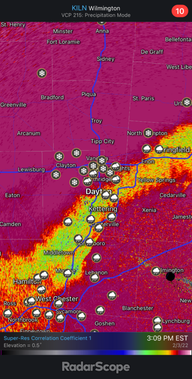
  13. Good to see the snow line moving south now.  Bradford and Greenville are both roughly  west of Franklin County, so the snow line is not that far north, especially looking at the thicknesses.  I would think it should arrive in the Columbus area before 5.   

×
×
  • Create New...