

jbcmh81
-
Posts
8,188 -
Joined
-
Last visited
Content Type
Profiles
Blogs
Forums
American Weather
Media Demo
Store
Gallery
Posts posted by jbcmh81
-
-
1.5" at KCMH through 1:30. Can alweays count on them to be the lowest in the area, but in this case, that's way below everyone else. Not sure how that could be true.
-
Looks like an active pattern with at least chances of snow, but potentially lots of riding the line in the typical spots.
-
 1
1
-
-
2 hours ago, sojitodd said:
Columbus officially at John Glenn got 4.8 inches of snow as of 7am.
(at least this is what I saw when I was looking at Minnesota totals and was able to move over and they had this report and 4.6 inches 2 miles east of Upper Arlington.)
Could be around 5"+ or so for the airport considering it's actually been snowing a bit all morning it seems.
Also, if not for the midnight high deal, today probably would've been Columbus' coldest day for this date in history. Clearly is going to be an afternoon high below zero, but the official high will be 33. The coldest high for the date is 11, so today would've blown that away.
Tomorrow will probably be 1st or 2nd coldest Christmas Eve ever, as well.
-
1
-
-
Outside of the lake effect belts, parts of Ohio seemed to do the best with snow. Nothing insane, but a general 4"-5" in most places.
-
2
-
-
It's too bad there was a midnight high for most of the area or it would easily be one of the coldest December days ever.
-
Downtown Live Webcam | Troy, OH - Official Website (troyohio.gov)
Looks like it's coming down good in the Dayton area now.
-
55 minutes ago, buckeye said:
well all that's left is to fire up the radar and the meso models, kick back a few and make sure I'm up at 2am to watch this front come thru. Media is calling this a "once in a generation weather front"....may it live up to the hype and bring us more surprise then disappointment

Still will never beat December 14-15, 1901. Went from 65 to -4.
-
Either too amped and too far west for decent snow, or too weak and still not far enough east for anything decent. I don't think this is breaking the December historic trend.
-
1
-
-
1 hour ago, Gino27 said:
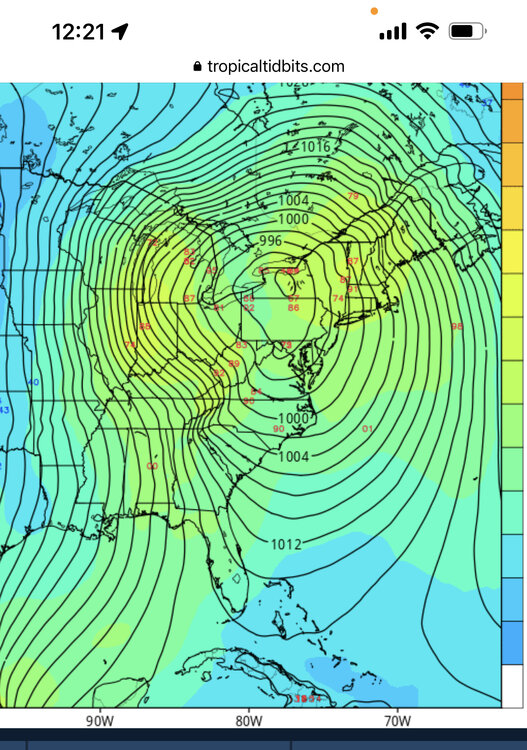
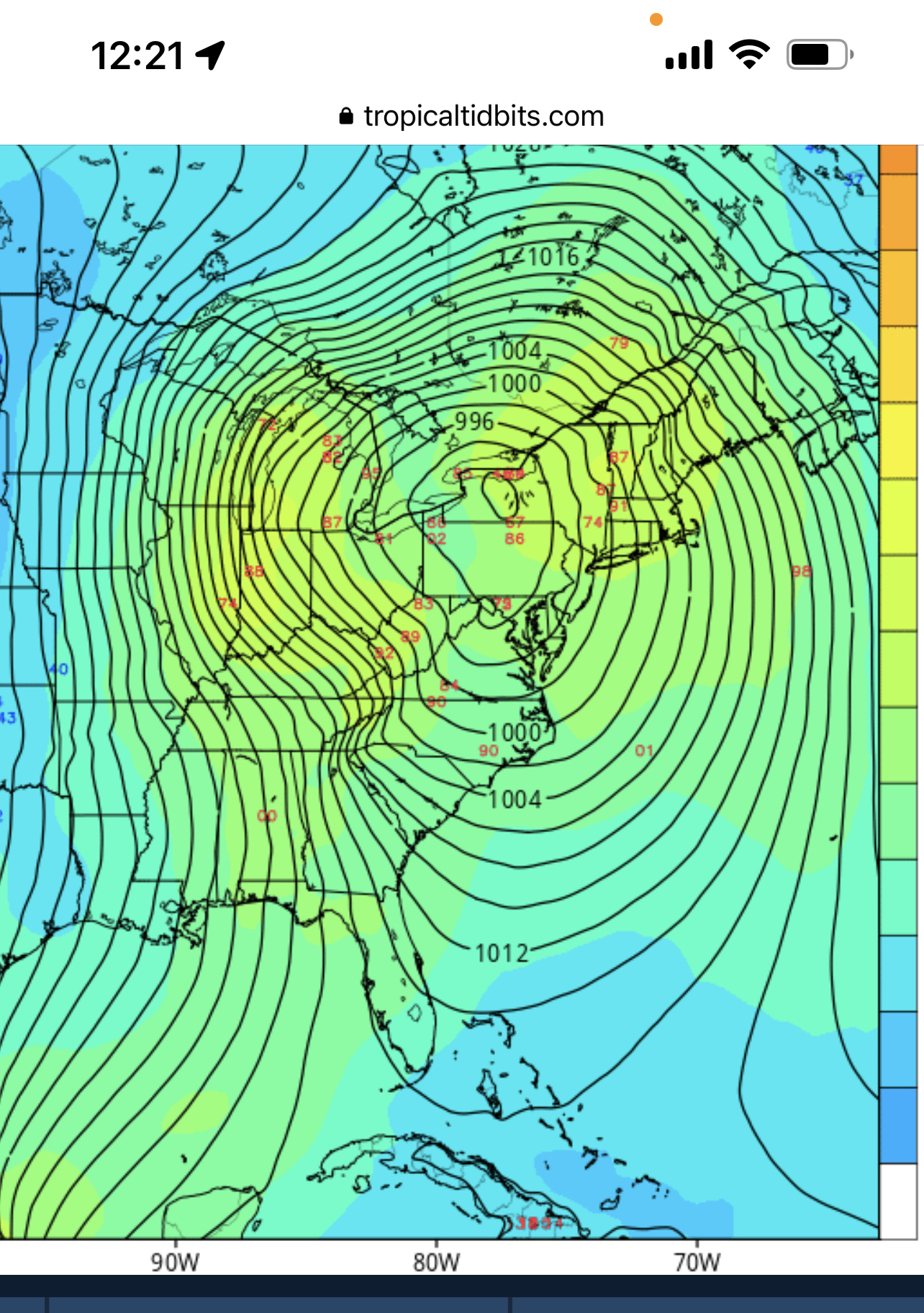
GFS takes a big jump to the NE. The east trend we are probably rooting for might actually be the worst case scenario if we don't get a favorable axis on the trowel with the low too far north. Then we're limited on our backside potential.
Climo finds a way.
-
5 minutes ago, buckeye said:
2” in Westerville? Seems low. I don’t recall much snow on the ground left by evening after a day of fog drizzle and mild temps…and any snow that was already on the ground would have turned to glacier when we had the flash freeze and would not have been an issue in blowing and drifting. So essentially that would mean 2” of fresh snow paralyzed a city for a week and made travel impossible without a snowmobile.
That's what the records show. Seems Columbus and Franklin County may have been in a dry slot for a lot of the storm, which kind of makes sense given the track.
-
1 minute ago, buckeye said:
typical historic trends and climo are for typical storms....this is not going to be a typical storm.
I don't know whether the current track holds or it goes west or it goes east....nor does anyone else. I suppose this might be classified as a manitoba mauler?? If fail happens, (meaning getting the snowfall shaft), it won't be because of a warm tongue, it'll be a dryslot that screws someone. Sure there'll be rain ahead of the storm but models often underestimate how quickly the temps crash with such a dynamic system. This is not the type of system where we'll be waiting endlessly for sleet and rain to turn to snow, it'll be rain...bang...snow and wind. Whether we get 3" or a foot it's going to be a fun one. The blizzard of 78 only dropped 6 or 7 inches in a very short time and that closed the city for a week and was the deadliest and costliest winterstorm in our history.
Let's not offend mother nature by complaining about dendrite growth due to high winds
 . Let's jus get a memorable xmas eve snowstorm that we can tell our grandkids about. Besides, I have my first grandchild due xmas day! Going to be a fun week.
'
'
'
Columbus officially only had 4.4" with the main January 1978 blizzard. It probably seemed like more given there was already snow on the ground and the wind blew it all over the place. Obviously totals were larger the further west you went. But that storm also occurred a month later than this and the low tracked further east than the models currently have this storm. Not being a typical storm pattern or setup doesn't mean climo can necessarily be tossed completely. There can be exceptions even if there has never been an exception before. Definitely rooting for this to be a first.
Here were some local January 25-27, 1978 totals.
London: 19.0"
Marysville: 8.0"
Newark: 8.0"
Delaware: 5.0"
Columbus: 4.7"
Westerville: 2.0"
Outside Central Ohio
Toledo: 13.3"
Dayton: 12.9"
Mansfield: 12.7"
Findlay: 10.8"
Bellefontaine: 8.3"
Cleveland: 7.5"
Wilmington: 7.0"
Cincinnati: 6.9"
Akron: 4.2"
-
22 minutes ago, Gino27 said:
GEFS is pretty much exactly what we want to see at this range. Tons of moving parts and climo tells me this can’t go too much further west than overnight euro and gfs had it.
Climo would support a further west track, though. There's a reason Ohio tends not to get its biggest storms until January or even February.
-
1
-
-
48 minutes ago, buckeye said:
126 hr gefs…. Not exactly a set in stone track. Very dynamic system and doubtful exact track is nailed down outside of 72 hrs. Whatever happens this is a fun one to track.
Maybe other areas will fare better, but history isn't on Central Ohio's side. There has never been a single double-digit snowfall in Columbus for December in recorded history. The biggest Christmas Eve ever was just 2 years ago with 3.4". That's not a great track record for big snows. The month just isn't known for them, and the big storms tend to miss west. Still a few days to track as you said, but trends are looking very typical. Still think the wind is going to be the big story. Even with a few inchest on the wraparound, winds of 50MPH will produce blizzard conditions easily, so definitely a high-impact even even if not nearly what it's going to be further west.
-
Looking like more heartbreak for Ohio. Sorry guys. Snow isn't looking like much. Wind will probably be the main story.
-
Central Ohio deserves a decent snowstorm after 2 consecutive winters in which the largest predicted snowstorm turned into agonizing sleetfests at the last minute.
-
2
-
 1
1
-
-
5 hours ago, HighTechEE said:
12Z GFS not as much snow, but near zero temps for several days including Christmas Eve & Day!
Models are generally showing the coldest Christmas since 1983.
-
1
-
-
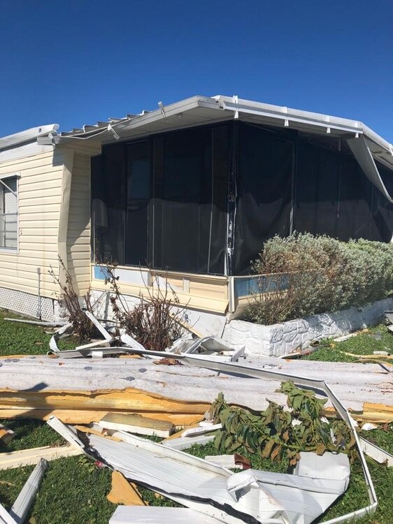
My mom's place in Ft. Myers. They are somewhat lucky. No flooding there and they didn't have major structural damage despite the appearance. But the retirement complex they live in is trashed and many people lost everything.
-
1
-
-
3 minutes ago, Chambana said:
No news or clips coming out of Cape Coral, that’s never a good sign. My aunt is there and I’m increasingly worried for her, haven’t heard from her in over an hour.
Surge may have peaked at 7.66', now dropping.
-
Ian wobbling east towards those idiots. They had better get to shelter now.
-
 1
1
-
-
6 minutes ago, tiger_deF said:

Future Darwin Award winner.
-
2
-
1
-
-
Sister lives in Cape Coral and mother in N. Ft. Myers. Not sure either will have a home after this, but at least they weren't morons and evacuated yesterday.
-
2
-
-
Sleet changing to snow in Dublin per social media.
-
5 minutes ago, JayPSU said:
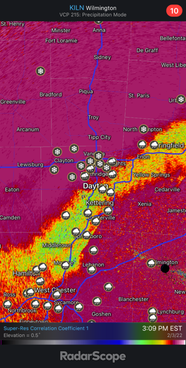
Dayton was reporting heavy snow at 3pm, so seems accurate.
-
Snow mixing in in Hilliard and New Albany now. It's trying.


Let’s talk weather!
in Lakes/Ohio Valley
Posted
Needs about 17" more to hit average. Not seeing it barring a 1987-style finish.