

weatherwiz
-
Posts
76,464 -
Joined
-
Last visited
Content Type
Profiles
Blogs
Forums
American Weather
Media Demo
Store
Gallery
Posts posted by weatherwiz
-
-
1 minute ago, ct_yankee said:
Interesting you say that about tomorrow being the better day, last night I almost posted to that effect... But I'm just not confident enough in my forecasting abilities, especially on this board with so many truly knowledgeable people, so I never hit the submit button. But yeah as of late last night I thought Wed could be the better day, although storms probably won't be as widespread as today - but that can be a good thing from a chasing perspective. I'll see how today plays out, then take another look at tomorrow.
Don't be afraid to post! that's what this place is for.
I am still torn on how today progresses (in the severe department). The CAPE is certainly quite impressive, especially the MLCAPE...values 2000-3000 J don't happen here all that often. We have the very steep low-level lapse rates/DCAPE which really screams at wind damage potential...however, given the poor deep layer shear I think we're really going to struggle to organize convection enough and develop deep enough convection to really produce outside of some isolated/localized areas of damage. How NY fares with this activity will be telling for us.
But I think tomorrow is looking better in terms of shear/instability combo
-
 1
1
-
-
Watch out
-
1
-
-
What happened to my badges

-
 1
1
-
 1
1
-
-
20 minutes ago, Typhoon Tip said:
Mm... I actually don't think that is the problem with today. Judging by sat trends, we should get a some good insolation periods mid afternoon.
I think premature detonation out in NYS may be a the issue for us. Like I was saying, there appears to be a bit of "zygote" convection axis already percolating out there astride I-90; that morning trend may set the table and it's already S of the northern edge of SPCs hashing. Then, looking at the 500 mb height lines and geostrophic wind direction, those cells should move S of due E - this latter aspect tends to not end big, with less N-E end of the Pike. They'll turn right - more right of the guidance too ... sending anvil spooge over us...
I'm sure this doesn't happen every time. But, after 30 years of suffering the vicissitudes of convection outlooks in SNE, the first order of business here is 'what can go wrong' will - particularly if you neglected to look for it haha
In a way this cloud debris may actually *help* things a bit. Given the high dewpoints and steep mid-level lapse rates we actually are destabilizing quite nicely. This cloud debris though may actually keep the mixed-layer capped a bit longer...holding off convective development. Also, this was really more of a late afternoon/early evening show anyways. Judging by sat trends we will see strong heating and once we really crank that the MLCIN should erode without problem. The RAP is getting MLCAPE upwards of 2500 J/KG which is pretty significant around here. It just sucks the mid-level is so bad...I think that's really going to hurt storm organization and limit how mature convection can get.
-
These differential heating boundaries should help to enhance llvl convergence across a few zones. I think tomorrow is looking pretty decent...could be rather active from southern VT/NH to just south of the Mass Pike. Could see several rounds of convection.
-
Tomorrow actually looks better than today I think for severe and some hints at another weak EML (which there is one too just south of us today)
-
1
-
-
Albany sounding not terrible looking. But this goes to show the best shear is going to be displaced a bit. Despite the fact we'll see numerous convection I think things are really going to struggle to organize

-
10 hours ago, DavisStraight said:
Looks like CT and RI shore gets the worst, you buying that Wiz?
Yeah I think CT/RI certainly see a good amount of convection today...just not certain how much in the way of severe we see.
-
1
-
-
29 minutes ago, CT Rain said:
I think the good flow at 700mb and nice 0-3km CAPE and decent lapse rates make up for some of this. I bet it's a pretty active day.
DCAPE is pretty impressive. With that and the steep llvl lapse rates certainly can’t rule out a decent amount of wind damage reports.
-
Definitely will see scattered-to-numerous thunderstorms tomorrow. Going to be very difficult to get organized or widespread severe given the poor mid-level wind fields and not great forcing. Think severe will be isolated despite the good CAPE
-
1
-
-
Temperature forecast tomorrow is quite interesting say across western Connecticut. Models show nicely warming 850/925 temps during the mid-to-late afternoon with some drying of the column. NBM for DXR also wants to get high's close to 75. I think that is a bit too aggressive but I wonder if there is room to sneak enough sun mid-to-late afternoon to push temps from say 68-70 to 72-74 later in the day
-
The rain last night in Bethel/Danbury was absolutely insane. Haven’t seen rates like that in a while. I had no hair protection either so when I went inside the package store I asked for a paper bag to cover my head when I went back out and used it to go into/out of Walmart too then back inside the house!
-
Just got a badge notification!!!!
I've been promoted to rookie
-
2
-
1
-
-
where do you see badges? It reminds me of Pokemon days.
-
I want a badge
-
 1
1
-
3
-
3
-
-
Come baby come!!!!!

-
15 minutes ago, Hoth said:
After almost a decade of regular posting on this board, I have apparently attained the rank of... "newbie". Beers on me, dudes!
Salut

-
2
-
2
-
-
woah this format looks like an elf turned on Santa after the elf was scolded for not producing enough toys
-
3
-
1
-
-
35 minutes ago, Hoth said:
Anyone else having issues getting COD radar to load?
COD been having lots of issues lately (though most tied into NCEP server issues) but the past week been lots of issues with loading.
-
1
-
-
I've always found 90's with 70's dews more tolerable and refreshing than temps in the 70's with dews in the 70's. You can definitely feel the difference in your hair. Your hair acts differently.
-
1
-
-
Bufkit is pissing me off. On one computer it keeps re-setting the Momentum Xfer option to 30 and on another computer it re-sets it to 1. WHY???????
-
5 minutes ago, MJO812 said:
NHC cone has shifted east since yesterday

A little shocked at that given the high clustering towards the western fringe of the cone.
-
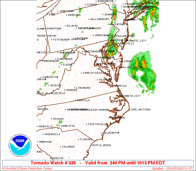
Anyone see the video of the tornado in Delaware yesterday? Tornado was basically going down the road with people driving through it lol. I wonder how many drivers knew it was a tornado.
-
1
-
-
Euro has been trash with tropical.
Anyways the pattern next week is rather intriguing. One thing we've noticed with the past few or several cold front passages is cold fronts aren't entirely progressing very far through the reigon...in fact, they've been getting held up nearby and we've seen waves of low pressure develop along them. GEFS shows a height configuration next week which would favor the same exact scenario with next week's FROPA

Now this isn't exactly being shown in the ENS mean due to smoothing but that trough dipping through southeast Canada into parts of the Northeast is not bad looking...and could certainly capture Elsa as it moves through the mid-Atlantic.
This might be a situation where the 500 look isn't striking at first glance for a hit but this isn't a storm that's riding the coast. In fact, given the potential track of Elsa you could argue this 500 look supports the capture potential.
Have to look back but I wonder if this configuration is similar to what brought the remnants of Katrina up this way. We had a pretty decent severe threat with that but were too capped in the end.
-
6
-
Severe Weather Thread - New England
in New England
Posted
Leaving Branford now...going to go to BDL (since I live there anyways but I can stop at the airport)