OceanStWx
-
Posts
19,758 -
Joined
-
Last visited
Content Type
Profiles
Blogs
Forums
American Weather
Media Demo
Store
Gallery
Everything posted by OceanStWx
-
Forecast/storm discussions and part II Manitoba Mauler
OceanStWx replied to Damage In Tolland's topic in New England
Let's not forget the NAM QPF rule. -
Forecast/storm discussions and part II Manitoba Mauler
OceanStWx replied to Damage In Tolland's topic in New England
Gut says the same, but it's going to be a delicate thing to back off what we have at this point and keep a pretty picture going. If you take 2/3 of the NAM and compare to the GFS, 14-18" is pretty close. -
Forecast/storm discussions and part II Manitoba Mauler
OceanStWx replied to Damage In Tolland's topic in New England
That's what lollis are for. You can write in the text or draw favored areas on a social media post, saying isolated amounts of 2 or 3 feet possible. Because I can guarantee you the only number people will remember form this forecast will be the 30+ amounts. -
Forecast/storm discussions and part II Manitoba Mauler
OceanStWx replied to Damage In Tolland's topic in New England
It's just a number to me (11) our coding doesn't list the color name. -
Forecast/storm discussions and part II Manitoba Mauler
OceanStWx replied to Damage In Tolland's topic in New England
I'm honestly not trying to be a wet blanket, but record storms are record storms for a reason - they are rare. As Ray just said, you kind of leave the record stuff for when you see the whites of its eyes. -
Forecast/storm discussions and part II Manitoba Mauler
OceanStWx replied to Damage In Tolland's topic in New England
Heck I discovered tonight that our snowfall web graphic had an error in the code that made 18-24" and 24-36" the same color. We didn't have Ginxy's chartreuse until we hit 36-48". I managed to find the error in the coding (as simple as a duplicate number 10). But these are the differences people notice between offices. -
Forecast/storm discussions and part II Manitoba Mauler
OceanStWx replied to Damage In Tolland's topic in New England
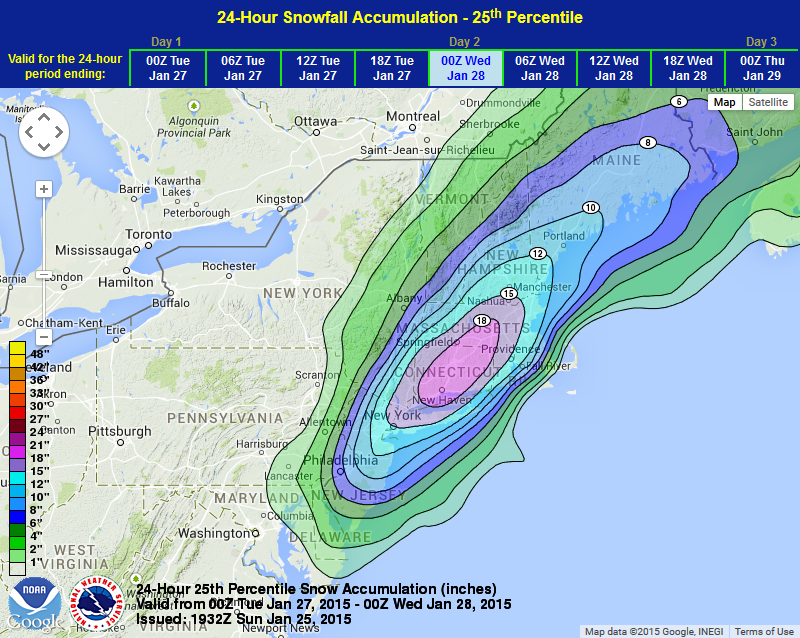
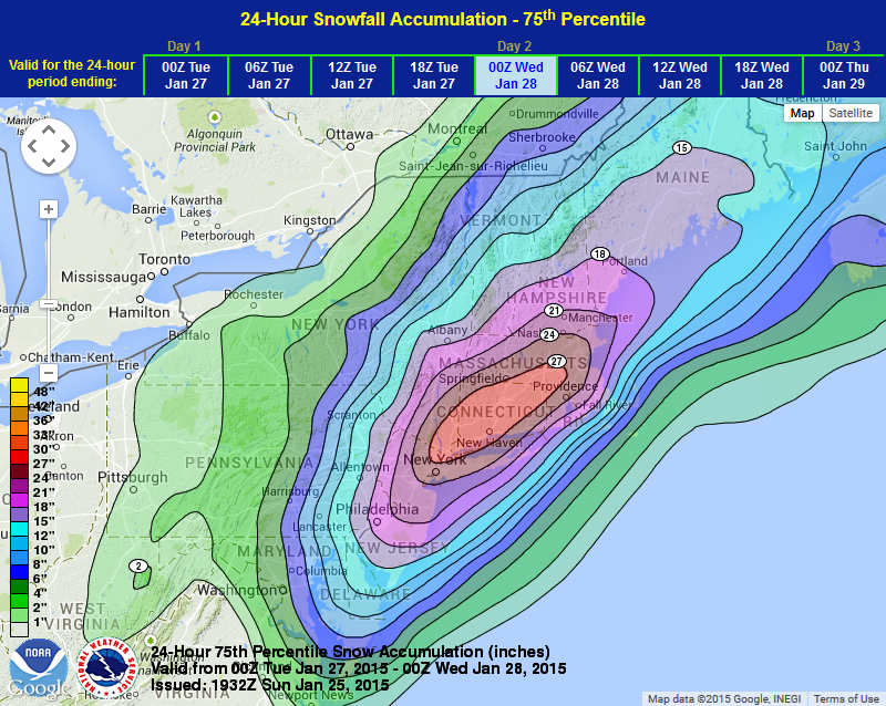
Makes it real hard to collaborate a pretty map when you get one office running nude through the streets. This is probably an exercise in futility considering most people around here, but folks really need to beware of some caution flags. I'm not saying this won't be a great storm, but locking in record totals from NYC through BOS is dangerous. If you check BOX's experimental snowfall graphics, their most likely total is only an inch or two lower than the maximum, and 10-15 inches higher in some cases than their minimum. That to me says it all. We (as an organization) got a little carried away and started forecasting totals too close to the maximum possible rather than the most likely. I like thinking about it in terms of the HPC graphics. I can't post graphics right now for whatever reason, but in essence 3 out of 4 forecasts are greater than 18 inches, and 3 out of 4 forecasts are less than 27 inches. There's maybe the range you should be thinking about, rather than 24-36 inches.
-
Nice catch, and excellent use of depolarization.
-
I would have a hard time believing true sleet (i.e. total melting even with latent heating going on). It's not unprecedented though, as the Groundhog Day blizzard in 2011 saw similar reports in northern Illinois. And if lightning was as prolific last winter as in 2011 I would have to imagine at least some graupel production would be going on to generate those kind of charge separations necessary. If truly intense upgright convection formed, I could envision a scenario where enough super-cooled water was lofted to form hail from these suspended graupel particles.
-
Alaska/Western Canada obs and discussion
OceanStWx replied to patrick7032's topic in Central/Western States
I think my best involved a strong clipper. We got about a quarter inch of solid glaze ice and winds were sustained 35 gusting to 45/50 mph behind the system for the evening launch. Now our UA building has doors that face north and south, so a westerly wind is basically pick your poison for which door to attempt to run out. I set the sonde up outside in an easy position for my free hand to grab it, because I know the balloon is going to catch the wind right away. This is something I had done many times before. So I come out the door and now the balloon grabs the wind and I'm being dragged down the ice with absolutely no traction to stop. I slide right past the sonde and end up crawling on my hands and knees to get back to it. After all that effort the balloon still got caught in an eddy and the sonde ended up bouncing. I mean that balloon is never going to lift you off the ground, but without traction is will take you for a ride. I can only imagine how it reacts once you're over hurricane force. -
Alaska/Western Canada obs and discussion
OceanStWx replied to patrick7032's topic in Central/Western States
Those high wind launches are always your best stories, and the ones you'll remember. Though I can honestly say I never had the pleasure of even approaching 65 mph. -
What's the most unstable sounding you've ever seen?
OceanStWx replied to Hoosier's topic in Lakes/Ohio Valley
My first day of work at DVN, I remember I came back in to assist with the evening launch and comms. I remember wondering what I got myself into when the temps around 00z were close to 85/80. Funny though that 6/18/09 immediately popped into my head when I saw the question, despite this sounding having the higher CAPE values. -
Historic Tornado Outbreak April 27, 2011
OceanStWx replied to CUmet's topic in Weather Forecasting and Discussion
Well I'm not sure the reaction extended that far up the chain, but my guess is that politicians were leaning heavily on department and agency heads for answers as to why so many people died. These politicians of course had no prior knowledge regarding the forecast/warnings and just see the end result. The service assessment began this week, and what I'm personally hoping comes out of it is a focus on preparedness and response/action. Some of these deaths were inevitable, but I also feel that a number (probably significant) of them could have been spared with better preparedness leading up to and better response during the event. -
Historic Tornado Outbreak April 27, 2011
OceanStWx replied to CUmet's topic in Weather Forecasting and Discussion
I attended a conference where one of the surveyors gave a presentation on rating the Elie tornado. It was interesting how they went about it. Even though it directly impacted some man made structures they didn't feel like they had enough information to go on. They ended up using video (from a tripod) to track debris of known size to determine wind speed. Regardless, great thought, effort and care went into that rating. -
Historic Tornado Outbreak April 27, 2011
OceanStWx replied to CUmet's topic in Weather Forecasting and Discussion
Higher than HQ from what I understand, as in "what did we do wrong to have so many people die?" Edit: I do, however, think we should question how we can keep fewer people from dying. But I don't necessarily think anything was done wrong. -
Historic Tornado Outbreak April 27, 2011
OceanStWx replied to CUmet's topic in Weather Forecasting and Discussion
In addition to two other EF3s that went through Marion County. -
Historic Tornado Outbreak April 27, 2011
OceanStWx replied to CUmet's topic in Weather Forecasting and Discussion
I understand that infrastructure was compromised from morning convection, but this is my opportunity to preach preparedness. Many large events are often preceded by morning convection, some of which is severe and does damage. Especially with an event as well forecast as this, I don't think there should be thousands of people being caught off guard. A $20 weather radio with back up batteries can go a long way. For every inconvenience of being woken up in the middle of the night for a false alarm, there is a life saved and that's worth it. I know it pains me to hear these stories about "no warning" when in reality it was not receiving a warning. I can't imagine how it feels for the many, many warning forecasters out there who issued good warnings but had people perish anyway. I have already heard some disturbing reactions from the higher ups in DC, and it will be very interesting to see how the service assessment plays out. Will it be a blame game or will we actually figure out some new ways to reach people and disseminate the message. -
Historic Tornado Outbreak April 27, 2011
OceanStWx replied to CUmet's topic in Weather Forecasting and Discussion
I see what you're saying now, but still seems odd to me to have a tornado that short produce damage that extreme. Truly a violent vortex if that's the case. -
Historic Tornado Outbreak April 27, 2011
OceanStWx replied to CUmet's topic in Weather Forecasting and Discussion
My guess is that this is the path length in the CWA only. If you check out a map, it is roughly 3 miles to the AL border. That information will likely be updated for final storm data purposes, once HUN finishes their surveys. -
Historic Tornado Outbreak April 27, 2011
OceanStWx replied to CUmet's topic in Weather Forecasting and Discussion
Paraphrasing a FEMA administrator in Tuscaloosa, they haven't even gotten to the damage in northern Alabama yet (i.e. Hackleburg, Phil Campbell, Decatur, etc.). -
Historic Tornado Outbreak April 27, 2011
OceanStWx replied to CUmet's topic in Weather Forecasting and Discussion
As did the latest CNN interview I saw. Leading them into the answer by asking if they heard, "any alarms before the tornado hit." I appreciate the hell on Earth they just went through, but Ringgold, GA was struck hours into the event. I don't understand how this could take people by surprise, to the point that they were outside when the tornado hit and they only ran inside when they saw a neighbor's roof come off. -
Historic Tornado Outbreak April 27, 2011
OceanStWx replied to CUmet's topic in Weather Forecasting and Discussion
Totally believable, as that supercell tracked all the way over the border. -
Historic Tornado Outbreak April 27, 2011
OceanStWx replied to CUmet's topic in Weather Forecasting and Discussion
I have no knowledge of whether it was or not, but I would lean towards warned because these signatures were just so apparent. I certainly hope that wasn't the case. Unfortunately, there will be a lot of "no warning" reports in the next couple of days despite the fact that there was a high risk, long lead PDS watch, and long lead warnings with aggressive wording. -
Historic Tornado Outbreak April 27, 2011
OceanStWx replied to CUmet's topic in Weather Forecasting and Discussion
The hours covering 21z/27 - 00z/28 will include the tornado that hit both Tuscaloosa and Birmingham. -
Historic Tornado Outbreak April 27, 2011
OceanStWx replied to CUmet's topic in Weather Forecasting and Discussion
For what specifically? The extreme part of the outbreak lasted well over 8 hours.