OceanStWx
-
Posts
19,758 -
Joined
-
Last visited
Content Type
Profiles
Blogs
Forums
American Weather
Media Demo
Store
Gallery
Everything posted by OceanStWx
-
Forecast/storm discussions and part II Manitoba Mauler
OceanStWx replied to Damage In Tolland's topic in New England
But yes, I am. I'm liking where I sit for the model consensus now. -
Forecast/storm discussions and part II Manitoba Mauler
OceanStWx replied to Damage In Tolland's topic in New England
Crush job at 18z. Full on blizzard conditions given the 900 mb wind speeds too. -
Forecast/storm discussions and part II Manitoba Mauler
OceanStWx replied to Damage In Tolland's topic in New England
I will say that NWP is pretty terrible at choosing surface low locations. I would focus more on upper level features (which admittedly is more difficult since we have so much real time MSLP data). -
Forecast/storm discussions and part II Manitoba Mauler
OceanStWx replied to Damage In Tolland's topic in New England
Curious to see what HPC does with the next update. Probably need to start thinking about sharpening the western edge. -
Forecast/storm discussions and part II Manitoba Mauler
OceanStWx replied to Damage In Tolland's topic in New England
I think that's the way you have to play it right now. It is the Euro, which gives you some pause, but if this was any other model that far west and juiced it would be tossed. -
Forecast/storm discussions and part II Manitoba Mauler
OceanStWx replied to Damage In Tolland's topic in New England
These hi-res models are in good shape based on radar right now. They take that banding and wash it out over NYC, while the meat and potatoes focuses from central LI on north and east. -
Forecast/storm discussions and part II Manitoba Mauler
OceanStWx replied to Damage In Tolland's topic in New England
00z 4 km NAM is similar, shade west of the RGEM. Really happy to be an eastern WFO for this one. -
Forecast/storm discussions and part II Manitoba Mauler
OceanStWx replied to Damage In Tolland's topic in New England
RGEM not favoring western areas from this point forward. I will say judging by radar it looks too far east, but probably not the scenario NYC wanted to see. -
Forecast/storm discussions and part II Manitoba Mauler
OceanStWx replied to Damage In Tolland's topic in New England
24" average at PWM. Even excluding the ARW members. -
Forecast/storm discussions and part II Manitoba Mauler
OceanStWx replied to Damage In Tolland's topic in New England
Bufkit soundings across SNE do have a little potential for TSSN tonight. -
Forecast/storm discussions and part II Manitoba Mauler
OceanStWx replied to Damage In Tolland's topic in New England
Lighting up nicely. -
Forecast/storm discussions and part II Manitoba Mauler
OceanStWx replied to Damage In Tolland's topic in New England
Pants optional at WFOs around New England. -
Forecast/storm discussions and part II Manitoba Mauler
OceanStWx replied to Damage In Tolland's topic in New England
That's one thing helping our case for blizzards. It's going to be a dry snow that should blow pretty easily, plus the depth of the cold air will allow for pretty efficient mixing compared to our usual inverted soundings. -
Forecast/storm discussions and part II Manitoba Mauler
OceanStWx replied to Damage In Tolland's topic in New England
Did you move to BGR? -
Forecast/storm discussions and part II Manitoba Mauler
OceanStWx replied to Damage In Tolland's topic in New England
I've seen breakers sending spray over roof tops and jumping the sea wall there, with storms that passed well out to sea. This is going to be pretty epic. I'm willing to bet a few homes pay the ultimate price on the shore. -
Forecast/storm discussions and part II Manitoba Mauler
OceanStWx replied to Damage In Tolland's topic in New England
Wave guidance is forecasting 29 feet in the bay. And it usually is underdone. -
Forecast/storm discussions and part II Manitoba Mauler
OceanStWx replied to Damage In Tolland's topic in New England
Sea spray finding it's way four lots back from the beach at Scituate? -
Forecast/storm discussions and part II Manitoba Mauler
OceanStWx replied to Damage In Tolland's topic in New England
Insider trading. Now conceivably they could hit their blizzard warning still with 6-10", but I think the media would have a field day if that's all that fell. -
Forecast/storm discussions and part II Manitoba Mauler
OceanStWx replied to Damage In Tolland's topic in New England
Playing with fire down at OKX. Either high fives all around, or some explaining to do. -
Forecast/storm discussions and part II Manitoba Mauler
OceanStWx replied to Damage In Tolland's topic in New England
Is your roof strapped down? 06-12z Tuesday eastern Mass is going to rock. Ginxy's favorite U wind anomalies got even more impressive on the 00z GEFS. -
Forecast/storm discussions and part II Manitoba Mauler
OceanStWx replied to Damage In Tolland's topic in New England
NAM Bufkit sounding for BOS is a little MAULish around 03z tonight. Wouldn't surprise me at all. -
Forecast/storm discussions and part II Manitoba Mauler
OceanStWx replied to Damage In Tolland's topic in New England
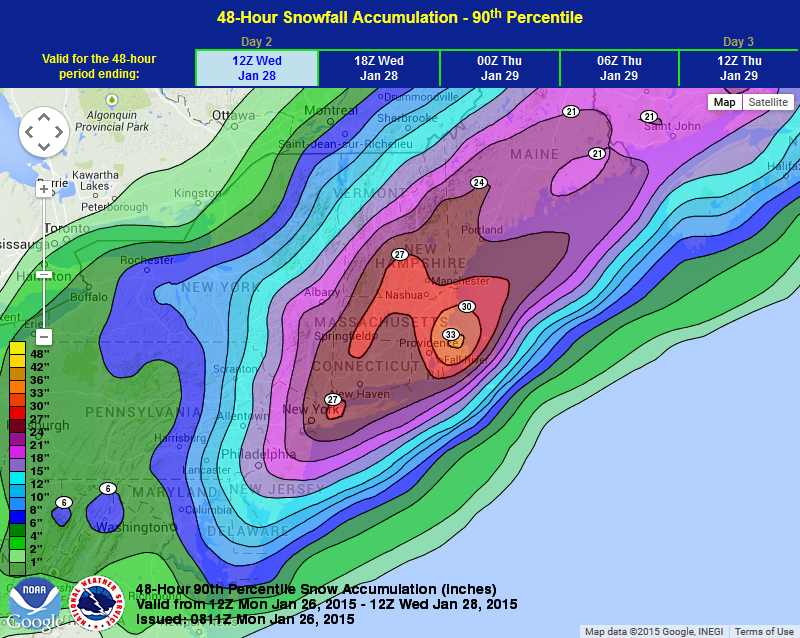
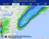
Here is a reason to spike footballs, 9 out of 10 times in this event we should see more snow than this graphic. That's not a bad lower bound. A good place to cap it is this graphic, 9 out of 10 times we end up lower than these amounts. This one does show HPC's thinking on the coastal front/OES enhancement jackpot, and the possible location of deformation jackpots.
-
Forecast/storm discussions and part II Manitoba Mauler
OceanStWx replied to Damage In Tolland's topic in New England
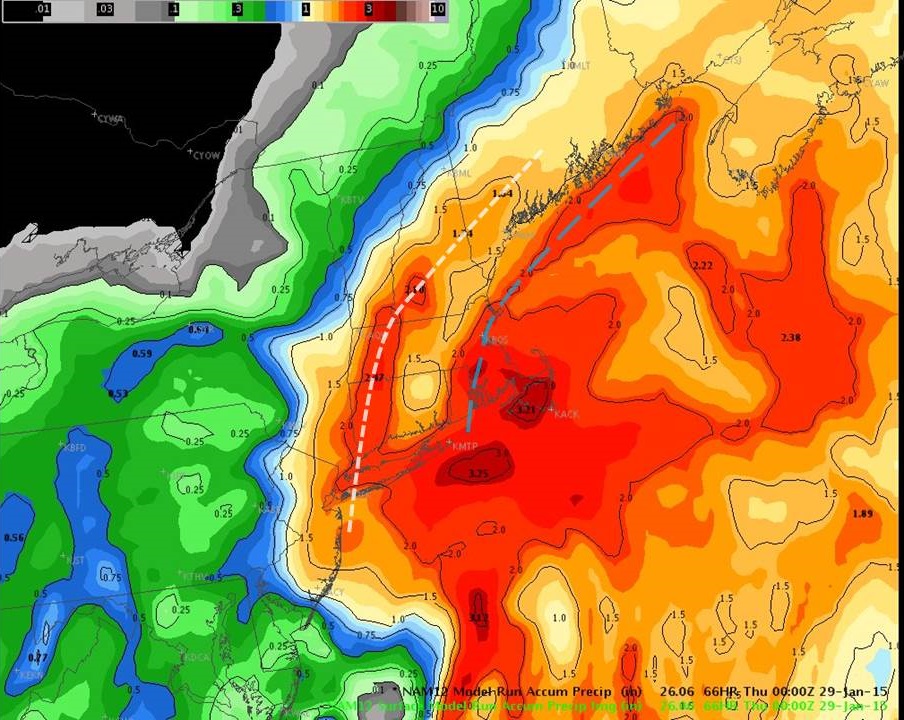
It's not hard to see the features in the QPF field. The deformation would be the white dash, and the coastal front the blue dash. And very much not run out of Kevin's basement.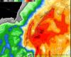

-
Forecast/storm discussions and part II Manitoba Mauler
OceanStWx replied to Damage In Tolland's topic in New England
Actually second look and that's west of the Euro features. Deformation setting up from DXR-BAF-EEN-IZG. Coastal front PVD-BOS then offshore of ME. -
Forecast/storm discussions and part II Manitoba Mauler
OceanStWx replied to Damage In Tolland's topic in New England
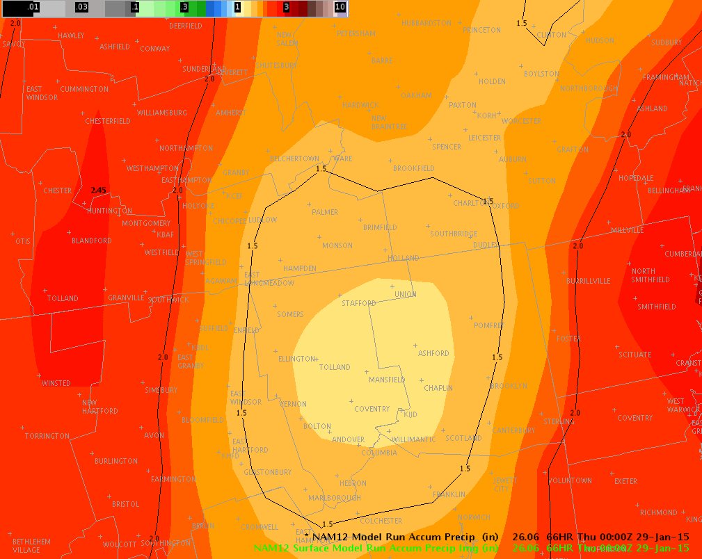
It's nearly an inch higher on the canal. Regardless, I do love the placement of QPF though. Really highlights the coastal front and then the deformation band. The placement of these features does match the Euro.