

MGorse
-
Posts
2,255 -
Joined
Content Type
Profiles
Blogs
Forums
American Weather
Media Demo
Store
Gallery
Everything posted by MGorse
-
Sprinkling now. Oh so close.
-
No rain here so far but it is not far to my north. Outflow just went through here though.
-
 The 700 mb FGEN was insane with this event, thus the crazy hourly snowfall rates and totals in a narrow band. This is from the SPC mesoscale analysis data.
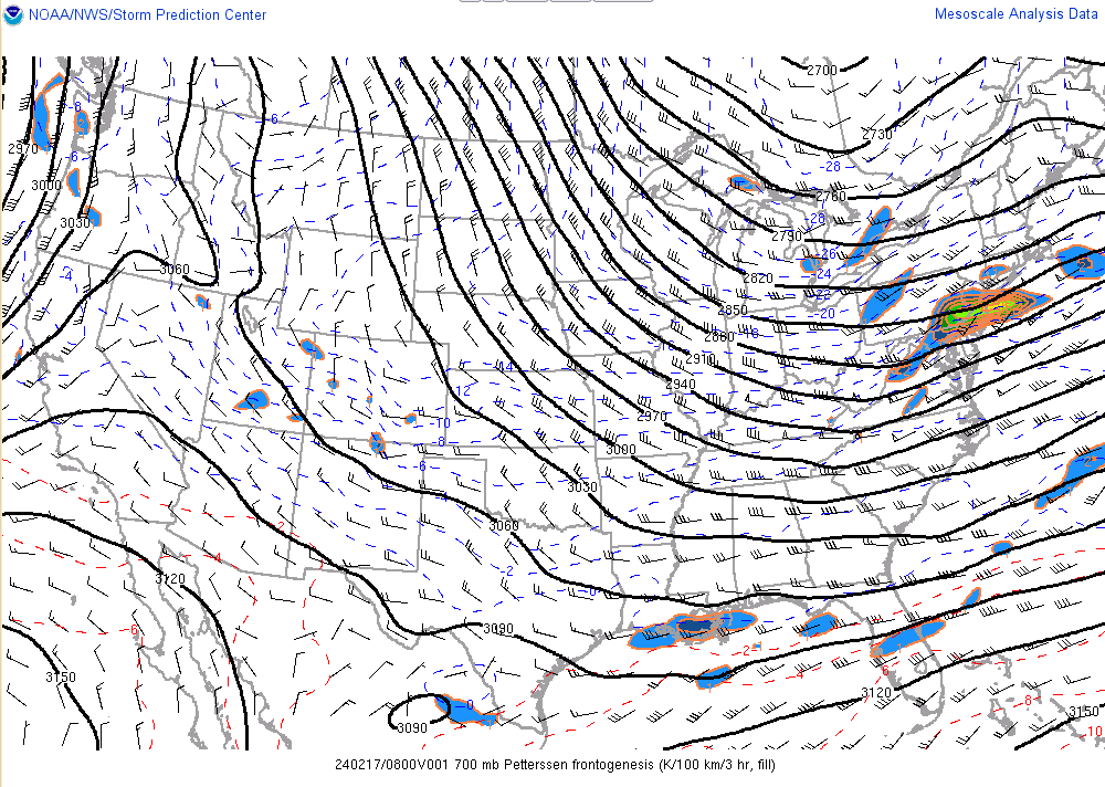
-
E PA/NJ/DE Winter 2023-2024 OBS/Discussion
MGorse replied to The Iceman's topic in Philadelphia Region
Radar beam tends to overshoot them at that distance from the radar. Snow squalls are usually lower topped. -
Snow Squall Warnings for the Poconos and the Lehigh Valley currently.
-
Yup the massive upward motion in that band that interesected the DGZ coupled with deep saturation resulted in much higher SLRs.
-
It is completely different. This was via very strong/deep frontogenesis in combination with upper level jet dynamics.
-
Easily half of the 4 inches of snow here has already melted.
-
The consistency of the snow was wetter than I thought it would be. Looks beautiful though covering all the trees.
-
4 inches at my place. Wow regarding that intense band that occurred. The look of it on radar looked like a fire hose of snow that Buffalo gets off Lake Erie. Insane!
-
I don’t think it is subsidence, but rather weaker lift outside of the strong lift that is producing the band.
-
That is a result of tightening 700 mb frontogentic forcing. This is sloped ascent and this narrow band is on the north side of the 700 mb frontogensis. That translates eastward, but let’s see if it remains so narrow like that.
-
Quick look at radar and the HRRR and it looks like the HRRR is not initializing the heavy band of snow in OH and western PA quite right.
-
Nope, my shift is wrapping up shortly.
-
Well, some of you got your upgrade to a Winter Storm Warning.
-
A little late for any winter storm watches to be issued. Advisories have already been issued, and some of those can always be upgraded to a warning if need be.
-
Impressive storm in more ways than one.
-
Delaware County is not split like that.
-
Their perspective will change when it is snowing at 1-2 inches per hour and the temperature is 32-34 degrees.
-
That is at 13z. Still snowing after that.
-
The main forecast updates are issued around 4 AM/PM.
-
The HREF is looked at but I would not say we rely heavily on it.
-
This is insane! I would literally be pulling my hair out if working today. Did mention over the weekend at work that this storm could be a surprise but was not sure where.
-
E PA/NJ/DE Winter 2023-2024 OBS/Discussion
MGorse replied to The Iceman's topic in Philadelphia Region
Because given the uncertainty the Winter Storm Watch covers a bit larger area. -
Yup, I missed that as well.


