

Jersey Andrew
-
Posts
164 -
Joined
-
Last visited
Content Type
Profiles
Blogs
Forums
American Weather
Media Demo
Store
Gallery
Posts posted by Jersey Andrew
-
-
4 minutes ago, WxUSAF said:
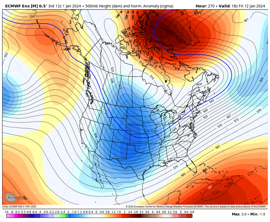
Trend seems to be for all the green, yellow, and red spots to completely change positions?
I guess 2/06/10 is not the top analog anymore.
-
 8
8
-
-
19 minutes ago, RDM said:
Good memories H2O. I joined Eastern early on - iirc it was late 99 or around 2000. But that was long ago. Recall reading about some of the snows in the WMA when living in Germany and then Thailand later, where we didn't get much snow. Was on some other forum/read board before that but don't recall the names. Joined the first one in 96 while living in Japan. I typically read more and post less out of reverence for those with more expertise, to whom I'm grateful for the knowledge transfer over the years.
Started lurking during Jan. 96 near the beginning of Internet when SNONUT and PTRAVEL broke down that epic storm. Still using AOL dial-up at the time which seems like the Stone Age.
-
 1
1
-
-
Just now, MJO812 said:
I still talk to Paul Kocin on Facebook. I miss him on TWC.
His two volume book on Northeast snowstorms is bible for winter weather weenies. Wonder if he participates in any weather discussion boards?
-
3
-
-
8 minutes ago, Ralph Wiggum said:
Jan 2016 woah
Jan 2016 was first forecast to be DC-Baltimore special with only glancing blow to NYC. I was living up in northeast Jersey at the time and was stunned we got 28 inches.
-
2
-
-
2 minutes ago, DarkSharkWX said:
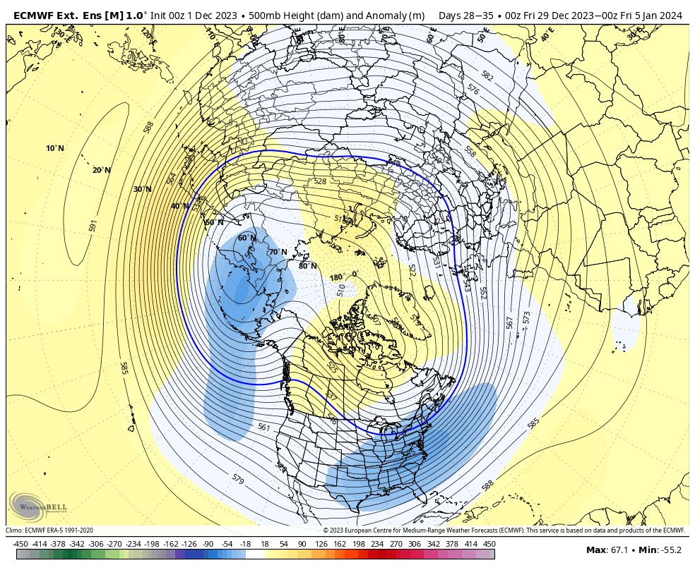
 just for fun cips analogs for the 7th
Question: What does top analog take into account? Pattern, progression, snow amounts?
-
1 minute ago, Terpeast said:
Interesting. So how do we use that information when comparing the GEFS with op GFS and other models?
Is the GEFS better at shorter lead times and less so at longer lead times (10-15+ days)?
Or if the op GFS takes a different track than the GEFS mean, do we lean more on the op GFS?
Actually think this hobby is so fascinating because of model discrepancies, biases, and disagreements. If they all agreed, would we enjoy the great chase as much? Gen Z will probably develop some AI that does away with uncertainty but until then enjoy the conversations and get ready for the Happy Hour GFS.
-
2
-
-
9 minutes ago, brooklynwx99 said:
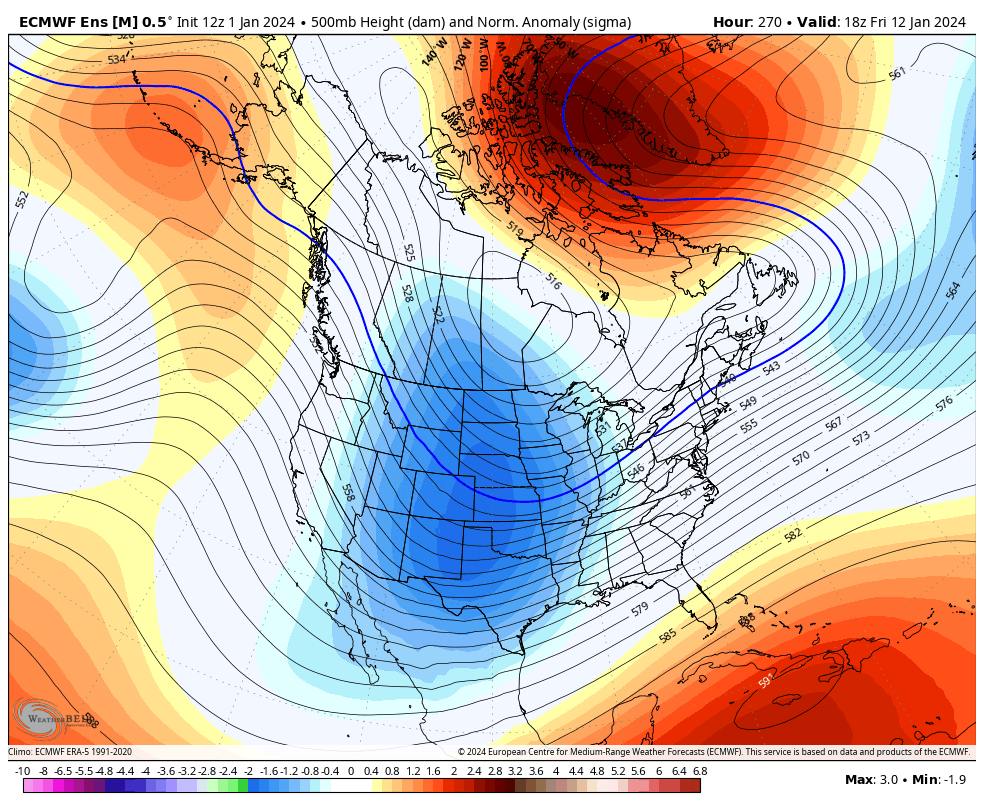
KU level block. 3 sigma at 12 days out is insane
Is their analog storm or pattern showing up for later January?
-
1
-
-
2 minutes ago, Ralph Wiggum said:
Pretty classic situation next weekend. Said it yesterday but took some heat for voicing what I was feeling after seeing the signal across all 3 ens means families. Will say it again....this has all the makings of a big hit to the left of the fall line, I95 the usual mix zone. Still think ops will bounce around quite a bit the next several days. But folks...we are tracking!!!
Looks like a ton heavy precip events in next couple months. If we go down like ‘73 or ‘98 so be it but I think we will hit some big snow events too.
-
1 minute ago, MJO812 said:
Another huge storm
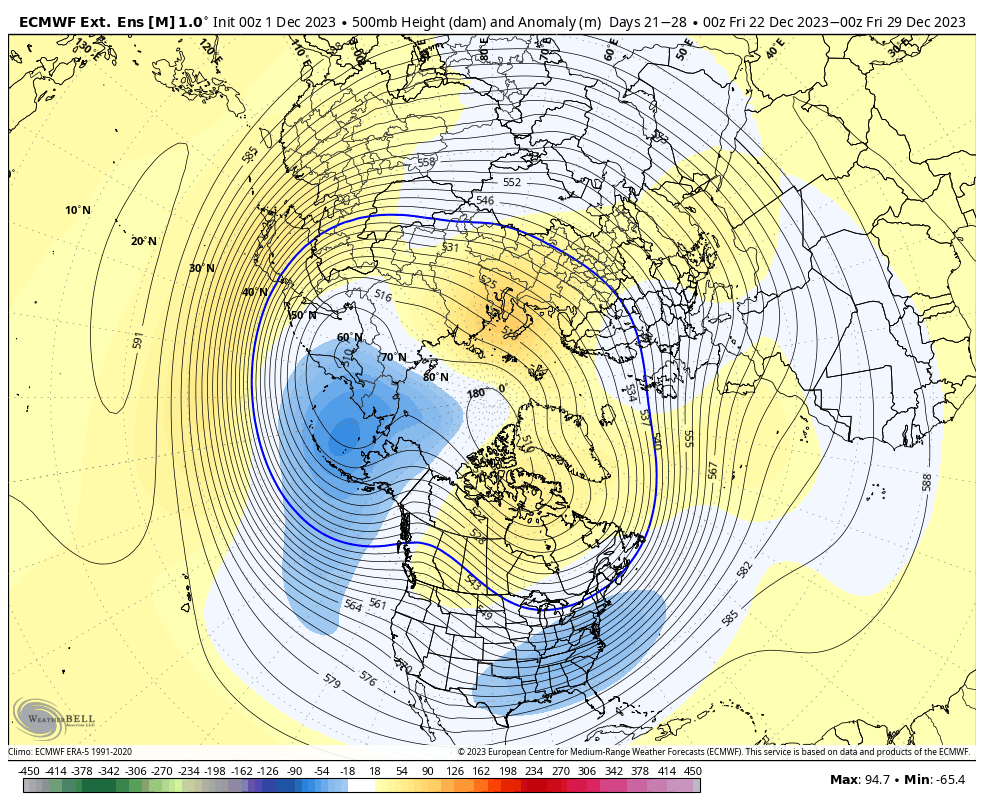
7th and 10th storm are huge on the euro.
Please tell me it’s snow for NYC on 10th. May be up in Manhattan that week.
-
21 minutes ago, psuhoffman said:
@Ji Case in point there have been 11 snowstorms of greater than 15” here since 1980. Every one of them was also a big storm for you. We share the same big storms.
Jan 96: 36”
Feb 11 2010: 30”
Jan 2016: 28”
Feb 2003: 28”
Feb 83: 28”
Feb 5 2010: 27”
Feb 2014: 23”
Dec 2009: 18”
Feb 1987: 18”
March 93: 17”
Feb 2006: 16”
Interesting that Jan 96 was the granddaddy of snowstorms for you rather than Feb 2010. Jan 96 was 2 feet for me in Fairfax while 2010 was around 28 inches. Feb 2010 must be Knickerbocker clone for DC metro.
-
2 minutes ago, psuhoffman said:
If we can get the pac to back off at all I think our chances are high still. I am acknowledging I am more nervous now than I was a month ago but I have by no means given up and put together my "time of death" winter call yet. I still think this works out. Just less sure than I was. As for the age thing...yea its frustrating but I can compartmentalize. I come on here, track, kill time, and in the moment when I analyze and dont see what I want its frustrating...then I log off and go do other stuff and it doesn't affect me at all.
Wonder if this will be a 1983 winter redux? Largely mild temps throughout January and February but just enough cold air to allow for monster Megalopolitan snowstorm.
-
1
-
-
1 minute ago, brooklynwx99 said:
agreed, although the 7th is low probability it’s still worth the most focus
Does it appear the seasonal EURO and CANSIPS will be incorrect and that the colder and snowy turn will not occur later in January into February?
-
15 minutes ago, Roger Smith said:
Don and/or bluewave can confirm exact details, but I believe 2023 will surprass previous contenders for warmest year at NYC (2012 and 2020 were close to being tied at 57.3 F), as long as it remains above 1991-2020 normal value. As latest projections are close to +3 anomaly for Dec, 2023 would average close to 57.5 or even 57.6. January set a pace and despite one or two cooler months like Nov, it will become new top of the heap.
Roger, does it even seem possible to have winters as cold as late 1970s in Northeast?
-
5 minutes ago, psuhoffman said:
Except for the 3 blizzards many still got more snow that winter than like 5 of the last 7! There was a 3-5” snow for the western burbs Dec 5. A coating late Dec. 1-3 early Jan. 4-7” late Jan. 3-5” early Feb. 1-3” in MD late Feb. And that’s ignoring the ridiculousness of “except for 3 blizzards” but yes I know you’re mostly kidding.
I’m fearful of a ‘97-98 scenario where there is no cold air in the DC area. Maybe that PV split delivers in January but even Judah Cohen is starting to hedge his bets.
-
 1
1
-
-
44 minutes ago, mattie g said:
I honestly didn't measure here in Burke because by the time I woke up there had already been decent melting and compaction, but our cul-de-sac caved fully and was quite icy at about 7:00. Checked our Ring and you could just make out how our walkway caved at about 3:30 and then eventually melted. I was also shocked that the snow on cars and other surfaces was crusty and not just wet.
I'm confident we had over 1" at the height of it.
Crazy to think that we've bested last winter on December 11 with a post-deluge/post-front event. I guess that says more about last year than it does this year.

I’m the next town over in Fairfax Station Clifton area and we finished at 1.1 inches. Also a large tree across the road in neighborhood which happens back in the woods. Yes already over last seasons snow total.
-
1
-
-
2 hours ago, Roger Smith said:
Not many U.S. stations go back into 1840s and 1850s, Toronto does, and you notice right away that winters in the 1840s were generally milder than in any decade until perhaps the 1930s, also snowfall tends to peak for Toronto around 1870. Winters were generally quite severe until the 1920s when a more modern trend began. I would not expect to find any location with similar temperatures in 1870s to 1890s as in recent times, it was generally quite a cold period, 1875, 1883 and 1888 are probably the three coldest years on record in any locations that observed back then. 1904 was also a very cold year.
Personally while I acknowledge the science behind climate change I think we just happened to peak in fossil fuel output at the worst possible time when natural variability was swinging towards its own peak. If we weren't here, a lot of these trends would still be in evidence. We are just making things a bit worse. Perhaps we will catch a break and run into a cooling trend on the natural variability side. Some thought it would happen with the solar downturn (which seems to be over already) but strong El Nino events like 2015-16 overwhelmed that possibility.
It will snow again, I don't believe the shift is that great, one encouraging sign, I just updated a data base for arctic Canada and winter 2022-23 was colder than almost all winters since 1970 and fairly similar to averages before 1970. This current winter is not as cold so far in the arctic regions.
Thanks for sharing some optimism Roger. Toronto can still get mighty cold in the winter as I experienced on some February trips up there for Super Bowl parties. Subzero lows and single digit highs reminded me of time spent in Chicago. The thing that surprised me though was the lack of massive snowstorms in Toronto’s history. No 20+ inch snows on record whereas NYC has 8 such storms and DC metro area at least 6.
-
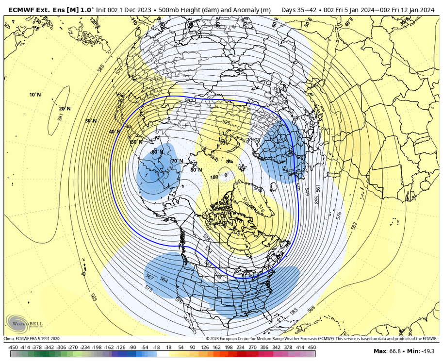
6 hours ago, donsutherland1 said:
The final chart following last season for NYC's warmest and least snowy winters. The score is the combined standard deviation from the historic DJF temperature and seasonal snowfall means.
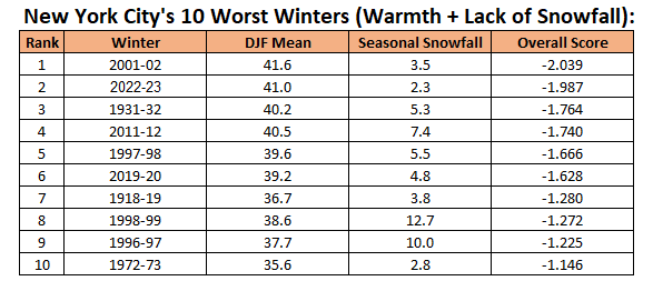
What is amazing to me is ‘73 was as bad a winter for snow in NYC and DC for that matter but was a full five degrees cooler than last year. That has to be climate change Don.
-
3 minutes ago, WEATHER53 said:
DC has kicked off some very good winters with early-mid Dec mega fronts which have ample moisture remaining post front. The post frontal moisture is a pattern that continues usually. When that kind of temp drop occurs in 2-4 hours there is usually real good support aloft temp wise
Are there any recent examples of December fronts kicking off snowfall after significant rainfall in the DC metro area?
-
25 minutes ago, brooklynwx99 said:
weeklies are straight weenie fuel from the holidays through mid Jan. makes sense as the MJO goes into favorable phases
What about lack of ridging on West Coast?
-
7 minutes ago, Wxoutlooksblog said:
It looks per the Euro that we're going to get into a clipper type pattern for a significant period of time. This means a milder day or two here and there but also repeated incursions of colder air with the risk of some light snow when the the clipper storm systems move across and there is some cold air still in place. Some of these systems may stay south of the NYC Metro but others could drop over the area from the north and west. As long as it lasts, these systems generally do not bring heavy or even moderate precipitation to the are so precip amounts should be near to perhaps a bit below normal. But we'll experience some cold and who knows, maybe we'll get lucky with a dusting to 2" at some point.
WX/PT
Do you think the pattern will turn colder/snowier as we get closer to Christmas?
-
1
-
2
-
-
3 hours ago, CAPE said:
Ridge position is going to be what it is based on the location if that GoA trough, which deepens with TPV energy dumping into it. Plenty of shortwave energy in the flow overtop the ridge then dropping into the base of the downstream trough, and that should sharpen it. It's pretty close to something good as is on the HH GFS.

Will it be cold enough to snow in Mid-Atlantic? December 6 is my birthday so I am rooting hard for snow.
-
27 minutes ago, psuhoffman said:
Two things can be true.
1)It can still snow if we get the right pattern2) it’s getting harder to snow as it warms and marginal setups that used to work do not anymore.
The hostile cycle of the pacific we’ve been in is very likely MORE to blame for our snow drought the last 7 years. Even had the climate not warmed the last 7 years were not going to be a good period given the pacific mean long wave pattern. But, we’ve had -pdo cycles before and they weren’t as bad in a colder base state. The warming is making bad worse.
Keep in mind as we lose marginal events my early season snow stats might become obsolete since most of those first 1” storms even up here were very marginal. We might just have to wait deeper into winter even in a good pattern to get snow. Of course that will limit and mute a snowy season some. But it doesn’t mean it won’t snow, just maybe we lose an early season marginal threat. We might also gain a threat mid season when added heat COULD even be a net benefit in some setups.
There are lots of variables to this. Terp did a great job quantifying this as best as possible given current evidence and data. But the two truths remain.
It can still snow. It is snowing less.
How do you reconcile big East Coast storms hitting 2006-2016 which deviated from historical norm in strength and size? Could climate change have accelerated since 2026 affecting worldwide weather patterns and base state?
-
1
-
-
47 minutes ago, MN Transplant said:
This board would implode with a late start like 65-66.
0.2" through January 25th. Then an 8-day period of three storms totaling 23" in late Jan/early Feb. Followed by a sloppy 5" storm in late Feb.
The Jan 29-30, 1966 storm does look like it was fun, though. 13.8" with highs of 16 and 17 degrees.
All stats from DCA.
86-87 was a slow start too from what I remember as 9 year old in DC area. Then Double whammy 1/22 and 1/26 lays down 20 inches and February had storms too. Doubt this will be a cold winter but hoping for the snowy part.
-
2
-
-
22 minutes ago, 40/70 Benchmark said:
The prospect of 2009 with a more pedestrian DM mean NAO intrigues me a great, great deal.
Can you expound upon why a less negative NAO could still produce snowstorms in 2023? It seems to me the deeply negative NAO of 2009-2010 may be off the board but maybe other factors come into play.
January 6-7 Storm Discussion: we’re due?
in Mid Atlantic
Posted
That’s quite a split in Fairfax County. Cannot imagine it winds up that way although I could see Reston and Chantilly getting more than Fairfax and Springfield.