

Jersey Andrew
-
Posts
164 -
Joined
-
Last visited
Content Type
Profiles
Blogs
Forums
American Weather
Media Demo
Store
Gallery
Posts posted by Jersey Andrew
-
-
10 minutes ago, psuhoffman said:
Things look fine Imo. I’m just engaging in speculation wrt what the outcome of this season could mean in the larger picture. I am in no means second guessing my expectations yet.
The sheer number of massive snowstorms to hit East Coast from 2006-2016 was historically anomalous and I wonder if climate change could have driven these outcomes. NYC had 20+ inch storms at least a half dozen times in this period when the previous hundred years they had two.
-
 1
1
-
-
8 minutes ago, clskinsfan said:
That wave the week after Thanksgiving on the GFS is something to watch imo. The setup is decent. Get the NS to phase in at the right time and it could work out.
And I agree with PSU about the lack of snow by December 15th. Out here it is the same. A no snow November/early December usually means a ratter. 2016 was saved with the storm of my lifetime. Or that winter was heading to a complete disaster as well. But I dont think we see no snow in either month. We are gonna have our chances.
December 2009 was an aberration in the past fifteen years. 2016 blizzard saved that season but so did February 2006 and 2003. I would rather long track a Big Dog than wait for a few paltry events. Just don’t know if climate change overwhelms perfect pattern.
-
1
-
-
15 minutes ago, raindancewx said:
We're on the board here for snow. Parts of the city had a dusting to an inch, with 0.3" at the official site. Timing remains pretty close to my analog "snow signal" composite. These were periods when measurable snow showed up in multiple analogs.
We had no rain or snow in town from 9/19-11/09, which is unusual in an El Nino. But I had two of the 10 lowest precipitation totals for that period as analogs with 1991 (0.26") and 1951 (0.42").
I've mentioned since 2015 that there is a direct negative correlation between Albuquerque and Philadelphia snow in El Nino. That relationship has been getting stronger with subsequent El Ninos (2015-16, 2018-19, 2019-20).
Do you expect a wet pattern this winter in desert Southwest including Las Vegas?
-
2 hours ago, brooklynwx99 said:
holy shit lmao
Does this have any similarities to December 2009 or am I just hallucinating?
-
4
-
-
2 minutes ago, Kevin Reilly said:
Umm what about Hurricane Mitch? Wasn't Hurricane Mitch below 900 mb?
Believe Mitch was sustained 180mph with 905 pressure.
-
2
-
-
1 minute ago, DDweatherman said:
Any guesses on where this one tops off folks? I'm thinking 175mph if I had to guess.
That would tie it with Camille which also got down to 900mb at one point. I think Gilbert was a little stronger at landfall in Central America. Would not shock me one bit if Lee sustained at 190mph with sub900 pressure.
-
 4
4
-
-
3 minutes ago, Rtd208 said:
What experimental Euro are they using? How does it differ from EPS?
-
4 minutes ago, TPAwx said:
Euro remains to be seen, even with some westward movement on other guidance no reason for local TB region media mets and municipal officials to let up on messaging and urgency, esp for Zone A and B residents,
After the debacle in Fort Myers last year surrounding late ordered evacuations, Tampa metro has to be very concerned about storm track and surge threat. Weren’t Zone A and B evacuated last year before Ian took a more southerly track? Tough decisions ahead.
-
3
-
-
Veterans Day 1987. I was 10 years old and school was first delayed and then cancelled. My father and I went out to run some errands and it took us over three hours to get home in raging snowstorm leaving a foot of snow. No cell phones back then and my Mom was ready to call the hospitals if we had not gotten home soon.
-
6 minutes ago, bluewave said:
The US population migration patterns are moving in the wrong direction for the current and future climate projections. The Northeast and Great Lakes should be the go to destinations for the way climate is a changing. But people have been leaving this region and heading south and west. Those areas have been experiencing serious drought, wildfires, heat, and major hurricanes. I will take my chances in a region that can experience too much rain like the other day over fires and multiyear drought. Plus those ares are also prone to flooding cycles also.
The humidity on East Coast is getting more miserable and unbearable each summer. Grew up in Virginia suburbs of DC in the 1980s and 1990s and it is way more uncomfortable now compared to then. Also lived a few summers out in Las Vegas and became well acclimated to the dry heat but that’s just me personally.
-
1
-
-
1 hour ago, SACRUS said:
80 / 72 and mostly cloudy. Steamy day ahead with widespread storms later in the day into the overnight. Mon (7/10) some lingering storms and clouds. Tue (7/11) - Thu (7/13) heats back up , humid and more low to mid 90s especially Wed (7/12). Scattered storms during the period.
Fri (7/14) and beyond overall warm to humid with western atlantic ridge along the coast keeping a warm southwest flow with pieces f the stronger heat moving up near or into the area at times. Trough into the GL nearby will keep storms nearby s warm humid and wetter continues. Overnight guidance kept the strongest heat just south till next weekend before skirting the area by the next mon (7/17).

How does last week of July look in NYC/northern Jersey temp wise and precipitation?
-
1
-
-
7 minutes ago, mattie g said:
Whatever that boom was about 10–15 minutes ago was really freaky. HearIng reports of a gas station explosion that registered as an earthquake.
Felt it about 3:05 sounded like a boom and house shook. No trees had fallen so wondering if it was an earthquake.
-
1 hour ago, CAPE said:
Tomorrow looks spectacular with temps mostly in the low 70s and dewpoints in the low 40s.
Maybe it will rain again around mid month.
Crazy dry conditions in DC area after little rain in May into early June. Even rain chances are evaporating.
-
40 minutes ago, Roger Smith said:
Years with significant heat in early June sometimes see a return to that heat on several more occasions (e.g., 1919, 1934) but another outcome is a rather cool mid-summer and more heat in September (1895, 1925). I suspect this will turn into a relatively hot summer with a few cool and wet intervals, in this climate, harder to avoid east coast ridge building over the anomalously warm NAtl.
It is also quite warm out here and pushing up a bit higher each day to mid-week.
My idea for the summer pattern in general is that it may be prone to severe heat waves in central states and the western interior, and that the east will alternate between near average and hot spells with a bit of a westerly rather than south-westerly flow bias which can mean a rather dry regime, but no doubt with a few interruptions.
I cannot remember the Mid-Atlantic DC region being this dry in May into early June. Don’t know what that means heat wise and for hurricane season but worth noting.
-
2 minutes ago, brooklynwx99 said:
very nice EPS run. great 500mb track

Would be absolutely stunned if snowstorm happens. Then again Veterans Day 1987.
-
5 minutes ago, psuhoffman said:
This isn’t me trying to be a Deb but I honestly don’t see the 18z Gfs as the win you do. I see a lot of the same WTF BS I’ve been taking notes for my book a lot lately. Let me explain.
First if all look at what the synoptic setup is BEFORE the run goes kinda crazy and pops out a once a decade solution.

look ANOTHER mid latitude system with no WAA snow associated with it to the north and northeast of the system.
Then it does this…

Ya ok…sure. Be honest what’s the odds that happens? That’s a 1/10 years type anomaly there. And even with that look at this BS

even with an amplifying system with a once a decade anomalous cutoff upper low slowly tracking under us it’s barely cold enough with rain moving in all through the CCB.
Ya it snows. And I can see why at a glance that looks like a W run. But what I see is it taking a ridiculous probably not gonna happen once a decade type progression to get snow and even still it’s like 4” in DC from what should be a MECS setup given the Synoptics and time of year. I don’t think that’s being pessimistic it’s just being realistic.
Sure that as shown there could happen. It’s very unlikely but not impossible. Eventually we will luck into some crazy anomaly. And if it does I’ll get excited at some point. But in the larger scheme if that’s what it takes to snow we’re still screwed. That’s the kind of crazy anomalous progression places like Raleigh NC should need to get snow not here.
Sorry if that’s too much of a downer after a “good” run but that’s how I see it.
Not trying to make synoptic comparisons but did we luck into 2/12/2006? I remember that being a crappy winter and then that storm comes out of nowhere seemingly as I think the Japanese model showed it happening.
-
27 minutes ago, psuhoffman said:
The guidance reminds me a little of January 1994. Hopefully if a similar thing repeats we can get a 50 mile shift south compared to 94. DC and Baltimore were so close to a big run but we’re slightly on the wrong side of the boundary almost every storm in 94. The gradient was extreme.
That was a very cold pattern. Two ice storms for DC area. Does this pattern resemble?
-
30 minutes ago, Roger Smith said:
The value of 8.6" matches Mar 5, 1981. Not qualified to say which events were surprises, as I never lived in the region (visited relatives in NJ a few times). I do recall quite a few of those storms as I was watching the weather from home base in southern Ontario and the wNY TV stations would always mention snowfalls downstate. The one in late Dec 1984 I recall because I noticed how odd that was to have snow followed immediately by a very warm spell setting records.
I will add 1991-92 to that list since you're interested, should be there fairly soon (I am not in the right part of the building to find the data on another device).
The 1980s were also a bit of a dead zone for heavy snowfalls in Ontario, in fact maybe worse, we missed most of the ones listed and didn't get as much compensatory cutter snow because the cutters cut hard most of the time. We did however get a monster 22" snowfall from Dec 8-10 1992, that one just kept going for about 36 hours. We got all that severe cold in 1980-81 without more than a couple of inches of snow each time, similar to NYC. Totally missed Feb83. Had a big snowstorm on Feb 28, 1984 that apparently you took as a warm sector.
Missed most of the 1987 to 1989 snowfalls listed, such as they were. Those were very dry winters with just bits of frozen snow from small events. I wouldn't say either that Toronto ever returned to old-fashioned snowfall amounts the way NYC did in the 21st century, the decline that began around the 1950s just kept digging in progressively, the old 19th century average of 70" has been reduced to maybe 40" nowadays. Toronto is not in a snow drought this winter however, they had several 2-4" falls in the past six weeks, each of which melted off quickly.
From a log of historic NYC temperatures that I compared to Toronto, I found that in January, all of the top ten for Toronto matched up with some members of the top twenty at NYC, the order is a bit random but within the NYC top twenty I think only Jan 1870 falls below the top quartile for Toronto and is still above the median despite there being a very feeble urban heat island for Toronto in 1870 (that became the snowiest winter for Toronto, March was especially heavy).
Toronto reminds me a lot of Chicago from a cold and snow perspective. Spent four years up at Northwestern on the Chicago lakeshore 1996-2000. Only one massive snowstorm in January 1999. A fair amount of subzero lows and nasty windchills which corresponds to my annual February trips up to Toronto. In fact Chicago weather prepared me well.
-
1
-
-
3 minutes ago, psuhoffman said:
Always a good idea, the snowiest model always performs well, especially when it’s a lone outlier!
MSP snowfall has absolutely no correlation to us. They’re 5 degrees north of us! I don’t have the data analysts to be conclusive of these yet but to make my point, an expanding pacific Hadley cell would likely be a net benefit to their snow climo but negative to us. A more prominent SE ridge from a hotter gulf and Atlantic would also help them and hurt us. Anything that shifts the baroclinic boundary north hurts us way more than them. Again using locations with vastly different climates isn’t valid to the case you’re trying to make. I’ve never claimed it’s getting harder to snow everywhere. I’ve said it’s become harder to snow HERE! What it does in MSP is irrelevant.
That’s one of the coldest individual frames. That’s bad because we’re still not on the cold side and rarely will the wave occur at the coldest point. Actually the waves are likely to happen at the warmest point due to basic physics of waves and the flow ahead of any wave. We really want to be well into the cold side of the boundary on a mean to survive the push north of the boundary ahead of any reasonable wave. It’s not an impossible look. But it would require a lot of luck. The last 7 years hasn’t made me feel lucky.
That article us junk. There is good science and bad. People need to use their brains and identify when something is based on sound evidence and analysis and when it’s sensationalism and click bait.
Nina’s strongly correlate to below avg snow here. Not no snow. Actually it’s almost unheard of to get this far into a Nina in this area with no snow, or like 2” in your case. Typically Nina’s have way less spread that other years and the vast majority historically end up near median snowfall in the area. Most of our truly god awful years we’re enso neutral (which can be great or awful, see 2014 and 2020) or super ninos like 73 & 98. This is very abnormal for a Nina.
How unusual is it for West Coast sopping rains in a La Niña?
-
The West Coast looks like an El Niño with atmospheric River and East Coast can’t catch a break. Is this going to be a 1983 big storm redux or 1998 shutout pattern?
-
1 minute ago, RCNYILWX said:
If consistency continues on this scenario, we in the NWS are really gonna have to hit the message hard about this being a life threatening blizzard, with incredibly cold temps for a system of this nature. Barring a big change in the evolution, the probability is increasingly high for the main swath to see extreme impacts. That's despite it being mainly a Thursday PM-Friday event. Have to give the overall run to run consistency of the Euro some credence at this point.
Sent from my SM-G998U using Tapatalk
How would this Chicago storm compare to 1967, 1979, 1999? More wind and power outages I assume. Can’t wait for Tom Skilling and WGN forecast maps.
-
1 minute ago, Chicago WX said:
What a day of runs. F*cking epic.

Could be Tom Skilling of WGN Super Bowl of storms. Having gone to school at Northwestern ‘96-2000, I saw how excited he got about January ‘99 snow that dropped nearly 22 inches at O’hare. Rooting for Chicago record!!
-
1
-
-
3 minutes ago, CentralVaNATS said:
Anyone looking at 850mb profile?
Also the Christmas am 2m temps?
Nuts if verified within 50%of that.
Iceberg
Sent from my SM-G998U using Tapatalk
What does it show? I believe Christmas 1983 was coldest in DC. High 14 Low 3.
-
31 minutes ago, psuhoffman said:
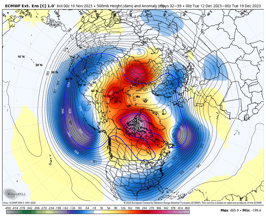
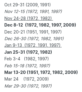
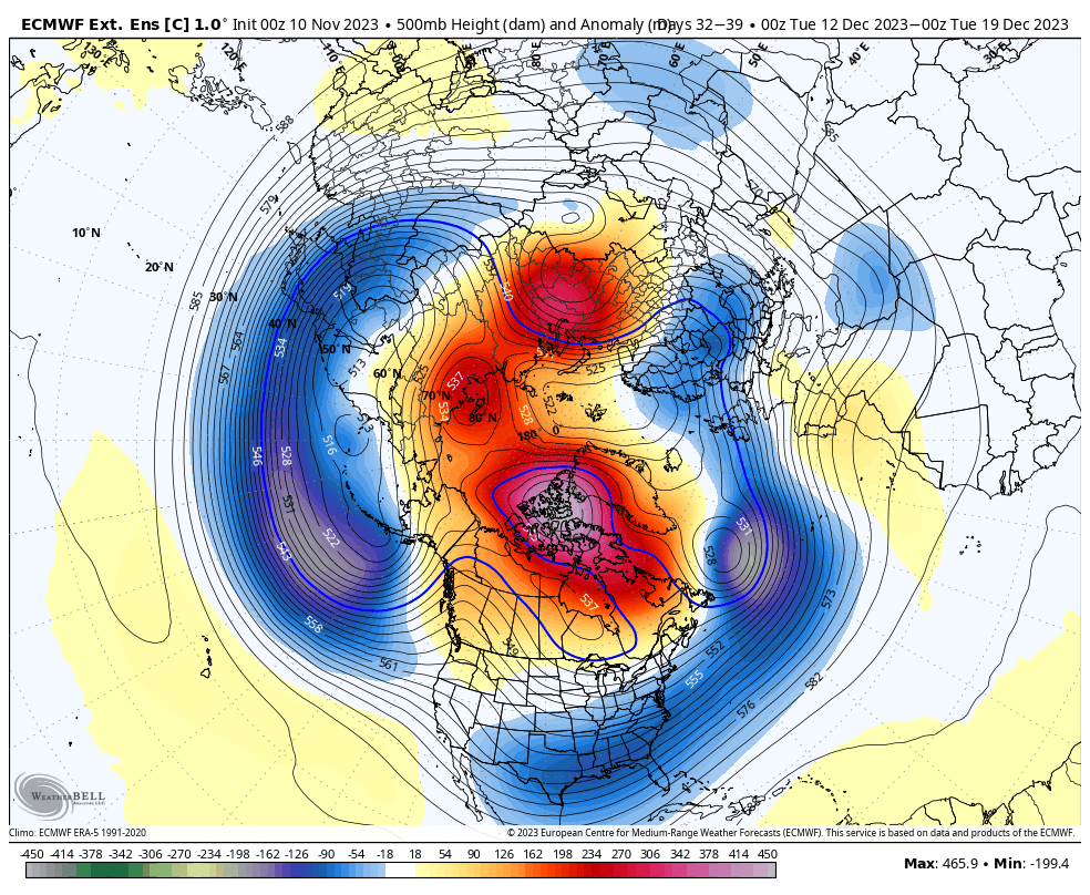
Details like the double barrel thing are useless at this range. From a pattern sense, west NAO block, 50/50, western ridge, TPV under the block that rotates a lobe and dives down to our SW, yea this setup resembles lots of our big snowstorms. But also a lot of close misses. It’s similar to December 2009. But it’s also similar to December 2010! I posted the h5 of 6 storms once and 3 were HECS and 3 were total busts and you couldn’t tell the difference. The pattern is great. We need luck with the details now.
I did not want to mention that storm from 12 years ago by name. Actually was living in northern New Jersey at the time where we cashed in. Back in NOVA now.


December 2023
in New York City Metro
Posted
Is this a snowstorm pattern for Mid-Atlantic or Northeast? Looks like it could be temp window before warmup.