

Jersey Andrew
-
Posts
240 -
Joined
-
Last visited
Content Type
Profiles
Blogs
Forums
American Weather
Media Demo
Store
Gallery
Posts posted by Jersey Andrew
-
-
10 year HECS intervals: 1996,2006,2016,2026
-
 9
9
-
 1
1
-
-
10 minutes ago, brooklynwx99 said:
lol 3km is just a more pedestrian 12-24" historic blizzard
Does this storm bear any resemblance to White Hurricane of 1888? Believe that started as rain too before heavy snow and wind slammed NYC and New England. Are 30 inch amounts plausible?
-
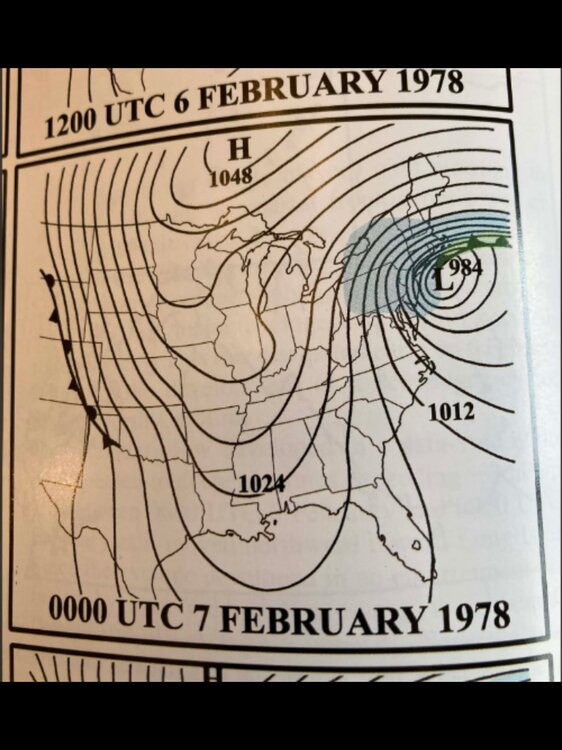
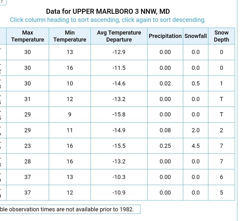
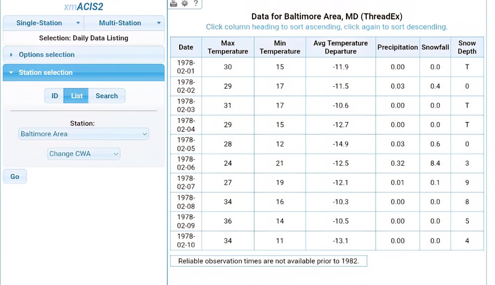
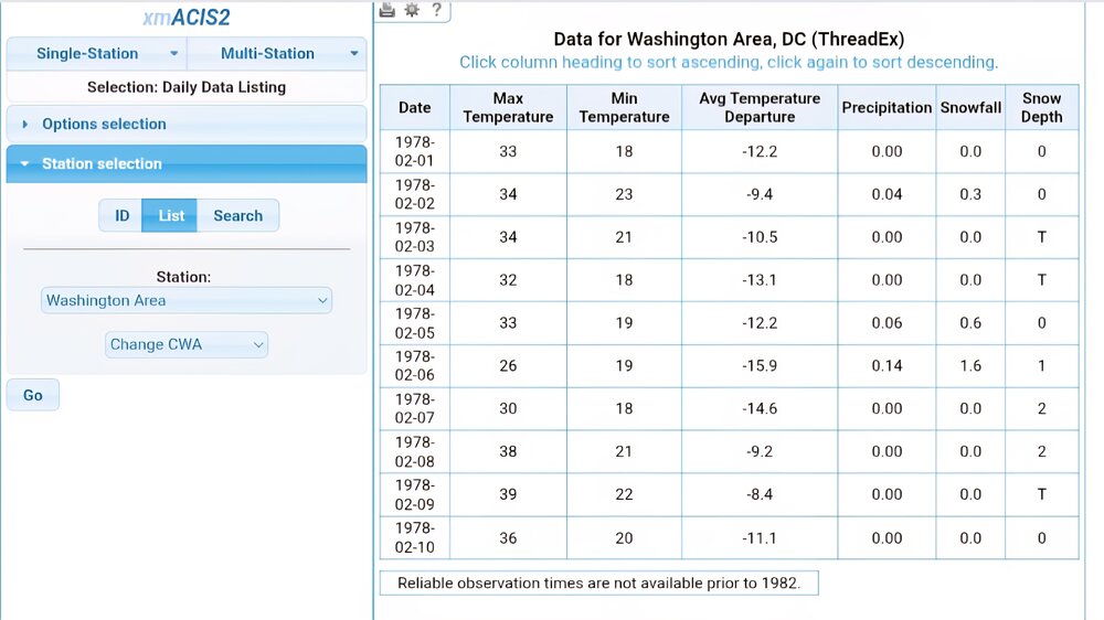
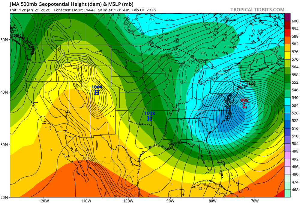
10 minutes ago, WxMan1 said:
Hey, we have an interesting analog! Feb 6-7, 1978. Very similar in terms of track and rate of deepening with the low along the coast. Certainly a top 10 storm for BOS... perhaps this will be one as well.
Interesting to see the snow totals around our area during the storm.
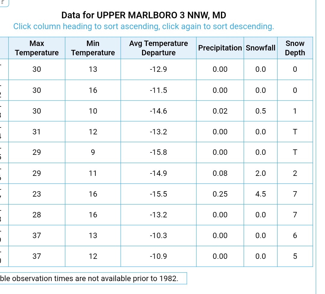
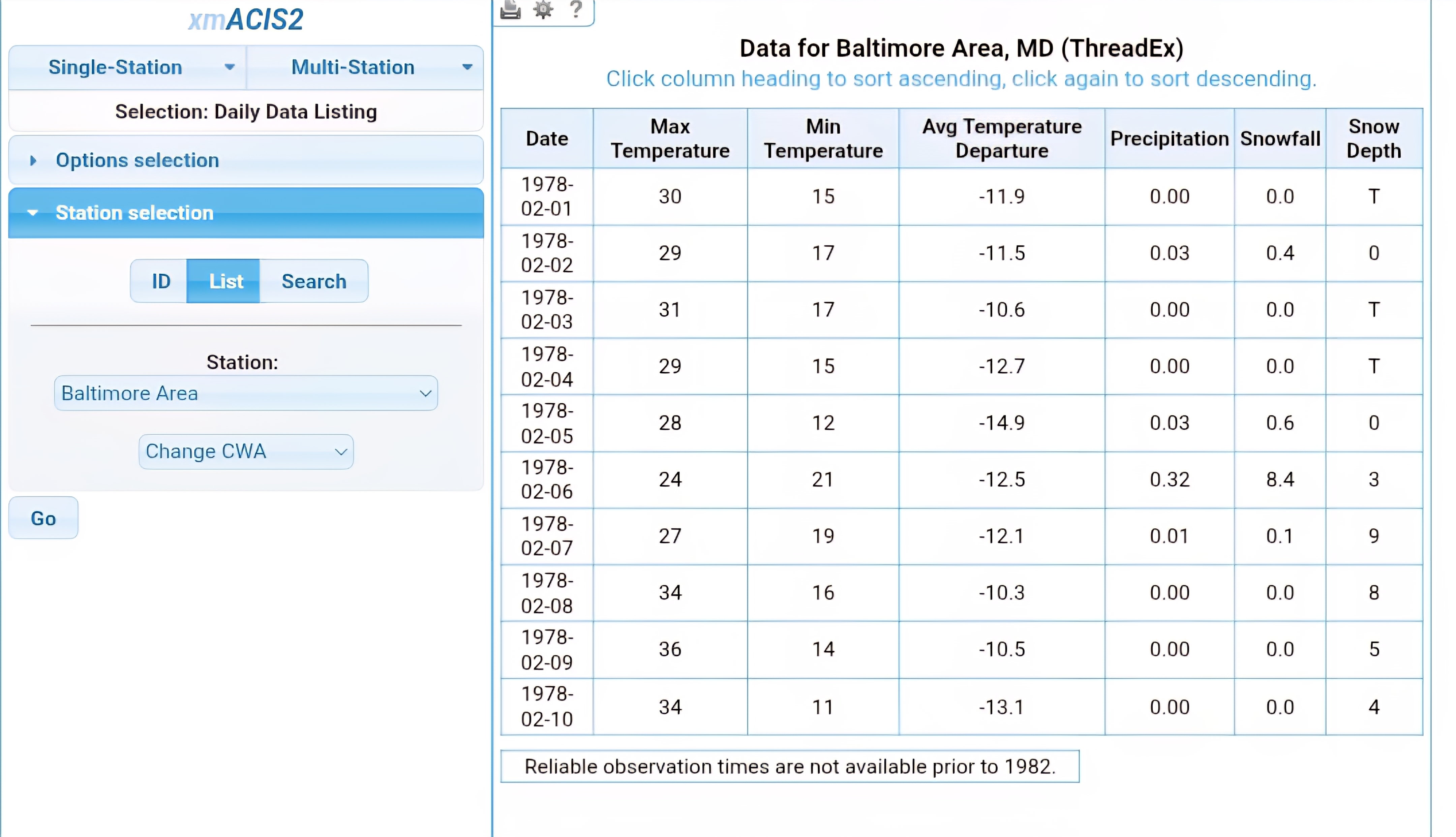
DCA 2.2"
BWI 9.1"
3 NNW Upper Marlboro 6.5"
Certainly a colder storm, but we could very well see sharp discrepancies in snow totals W-E with our storm tomorrow into Monday morning.
This does not seem like a DC special but 2/12/2006 gives me hope. DC gets light snow in afternoon amounting to an inch and storm bust is called on EasternWX. Then around midnight thunder and lightning strike NOVA suburbs and wake up to a foot of snow and trees down.
-
4
-
-
1 minute ago, beanskip said:
For those of you keeping score at home, 965 mb (as the 18z NAM just showed) would be the cutoff between Cat 2 and Cat 3 if this was tropical.
(Enjoying the hell out of watching y'all track this from down here in Tallahassee -- let the big dog eat!)
How low did White Hurricane of 1888 go?
-
Just now, LeesburgWx said:
What is the biggest move the euro has made in recent memory where it shifted to a huge solution for us instead of the usual opposite?
Boxing Day blizzard 12-26-2010 when Euro caught on to GFS and delivered a huge storm. Of course that was for NYC and New Jersey but u get the point. 2-12-2006 JMA schooled other models.
-
3
-
-
On 2/6/2026 at 10:15 AM, donsutherland1 said:
Uncertainty about the February 15-28 period has increased. What is fairly certain are the following:
1) Substantial warmup in the Plains States
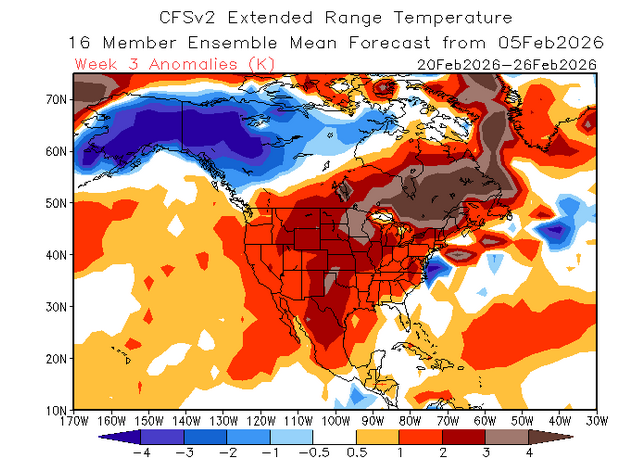
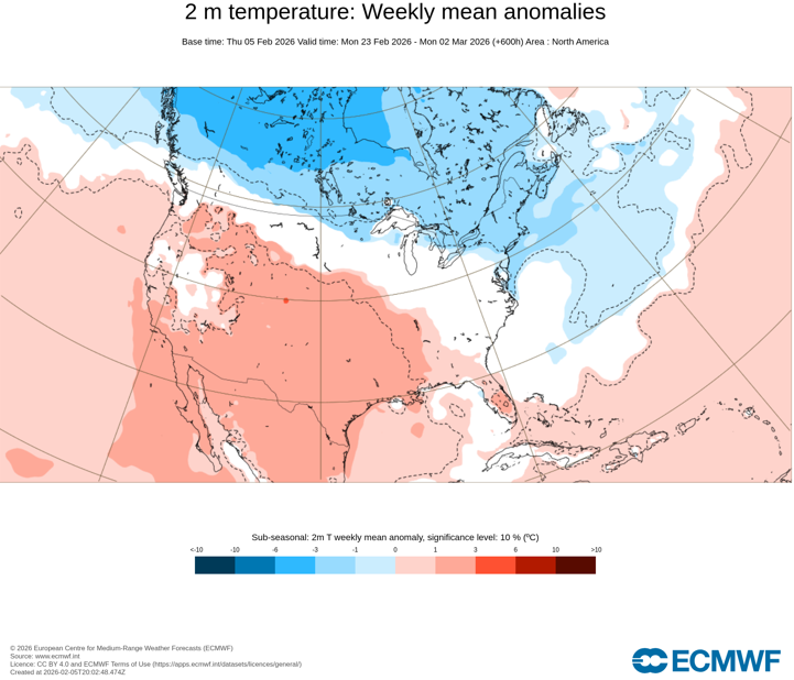
2) Brief cool shot to the Southwest and then a return of warmer conditions. The cool shot likely won't be sufficient to preclude Phoenix from experiencing its warmest winter on record.Moderation is likely to occur across the Great Lakes Region, Northeast, Mid-Atlantic, and Southeast during and after February 10th. What happens beyond 7-10 days is where things become increasingly uncertain. The CFSv2 favors a continuation of above normal temperatures through the end of February. The ECMWF weeklies bring colder conditions for the February 23-28 period.
CFSv2:
ECMWF Weeklies:
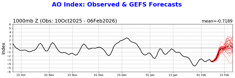
Even as wave lengths are shortening, the Arctic Oscillation (AO) could hold the key. The EPS and GEFS agree on the development of a WPO-, EPO+, PNA- pattern. During such patterns, conditions in the East tend to be much colder when the AO is negative than when it is positive.
New York City provides a good example. Since 1980, WPO-, EPO+, PNA-, AO- patterns have seen a mean February 15-28 temperature of 33.9°. In contrast, WPO-, EPO+, PNA-, AO+ patterns have seen a mean temperature of 44.5°. So, if the AO goes positive, the warmth from the Plains will likely come eastward.
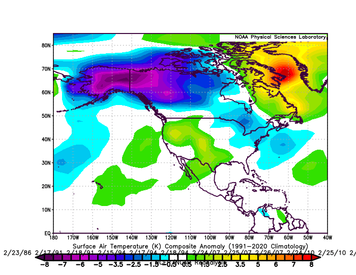
WPO-, EPO+, PNA-, AO- Patterns:
WPO-, EPO+, PNA-, AO+ Patterns:

The latest AO forecast is below.
A near neutral AO would favor near seasonable to somewhat above seasonable temperatures in the East. Historic experience following the breakdown of long-duration (25-day or longer) AO- regimes that began in February favors AO variability following the breakdown of such regimes. Only 1986 saw a prolonged and strong AO+ regime develop.
As noted previously, due to shortening wave lengths, the consensus outcome of a resumption of above normal temperatures in the Southwest to close out February is the base case.
Don, does the same uncertainty exist for the start of March? How about in the South?
-
17 minutes ago, psuhoffman said:
@Jersey Andrew but… I should add that 83 storm was a classic Nino STJ moisture bomb storm like Feb 2010 and Jan 2016. If we do get a MECS HECS storm it’s unlikely to have that level of STJ moisture feed. Even 96 didn’t. It had to snow for 36 hours to get those crazy totals in 1996. Our absolute top end is probably capped a little by the Nina. But we can definitely get VERY big snowstorms in a Nina.
Maybe next year if Super Nino develops we can see a 1983 or 2016 type storm.
-
6 minutes ago, psuhoffman said:
personally I am fine with what the AIFS Ens show...because I am done with the part of winter where I am worried about getting minor snowfalls...it's time to go big or go home...I am exclusively big game hunting once we get into mid February on. So I would much prefer a 6" mean from a handful of 20" storms in the ensemble...than a 6" mean from a bunch of 6" storms. Give me some HECS lottery tickets and I'll take my chances.
Is this a pattern where we can pull off a February 1983 type storm?
-
21 minutes ago, Heisy said:
Yeah it looks pretty likely that it is going to happen, question becomes, can we recover? The -PNA looks pretty rock solid. I bet we see some old fashioned Lakes cutters mid month/second half of the month. This is normal for any winter to go through thaw periods. It’s not a bad time for it to happen if we can get a reload by March. See what happensWasn’t that-PNA responsible for destroying what was supposed to be an epic February last year? Who knows if you can trust long range modeling.
-
4 minutes ago, MDSnow93 said:
In 10+ years of reading this forum I've never seen such low morale for seemingly no reason. We've got snow pack that's not going anywhere. We've got more cold air than I can remember seeing in a while. People are locking on to model runs 5+ days out just because it doesn't show what they want. It's pretty pathetic if I'm honest. We have smaller storms to track, and if you want a big dog, I'm no met, but in my experience those tend to come as the cold air retreats and we transition to a warmer period. Just my (worthless) 2 cents.
A lot of people in here thought February was setting up for a 2010 redux especially with long stretch of brutal cold. Will we really waste the month if PV suppresses everything to the south?
-
1
-
-
16 minutes ago, WEATHER53 said:
Back to back 14 day stretch I can’t think of one except maybe 1977
Went back and look turns out it was February 1979 leading into PDI storm
-
When is the last time DC had consecutive week of highs below 30?
-
1 minute ago, LeesburgWx said:
No one posted the Blizzard on the JMA?
It got 2/12/06 right so you never know.
-
1
-
1
-
-
How brutal will travel be this week DMV?
-
Just now, mitchnick said:
Rap new run
.thumb.png.4aa30a0a33ec19c285d9f63af6170211.png)
That’s a massive snowfall for NYC and northern Nj. Does it account for sleet or fit the atmospheric conditions, storm path?
-
Just now, mitchnick said:
It is. Here's the Rap currently updating out to 5pm
.thumb.png.d08dcf915eb73f5b91717701f7dab2fd.png)
Are these short term models like HRRR and RAP based on NAM or GFS?
-
1 minute ago, psuhoffman said:
It’s fine. 10” in DC. 12” IAD. 13” up here.
You don’t believe those higher totals do you? I’m afraid the NAM is right here and DC metro is 4-6. Hope I’m wrong.
-
1
-
 1
1
-
-
12 minutes ago, MillvilleWx said:
Feb 2006 was one of the greatest I-95 storms no one talks about. One of my all time favorites, hands down.
Tremendous storm with thundersnow. NOVA had one inch of snow in afternoon and I thought storm was a bust until lightning strike at 12:15a.m. And waking up to foot of snow and tree across the driveway.
-
2
-
-
Just now, WEATHER53 said:
What are the merits of this -5 to -10 temps afterwards? Could such a historic extreme produce any odd results during storm and when it ends?
I worry about the twin ice storms of January 1994 repeating history. Our driveway was a skating rink back then.
-
1
-
-
Just now, IronTy said:
Guys, I'm tired. I'm not sure my heart can take much more of this hobby.
If all the models lined up in unison, it would be no fun. This is the great chase for 2010,2016, or Knickerbocker redux. The fact we have pulled off some monsters in our lifetime makes it more interesting to follow.
-
3
-
-
Does this storm look like PDII type snowfall, sleet,ZR distribution areawide?
-
Just now, NorthArlington101 said:
AIFS is steady as she goes. Slight hair north

How does this model differ from regular Euro?
-
1 minute ago, MDScienceTeacher said:
I’m not sold on the PDII comparison quite yet because the QPF progs aren't showing that level of saturation. During PDII, we saw persistent mesoscale banding with radar returns so intense they would have prompted flash flood warnings in the summer.
That setup featured a textbook 'tropical tap' where a deep moisture plume from both the Gulf AND the Atlantic converged. The Water Transport was so off the charts because you had a secondary low off the Carolinas acting as a pump, feeding a SSE-to-NNW moisture flux directly into the cold dome.
Lift was maximized because that 1040mb Arctic High was so anchored, creating a steep vertical 'ramp' for the moisture to climb. We ended up with 2.5 to 3.5 inches of liquid equivalent (QPF) across the board.
Sure we have the 1040 high this time.. but as of now, this current setup looks more like a standard Gulf-dominant system—it lacks that intense Atlantic inflow and the same degree of frontogenesis we saw in '03. It has potential, but the 'firehose' isn't there yet. Could change.. hopefully it does. If I remember, PD2 was a 1 foot deal on the inital warnings.. only after it started training we started to see the 18-24 numbers show up in the warnings.
What about DC metro mixing over to sleet then back to snow? Still think this storm will be similar to PDII in that way.
-
1 minute ago, snowmagnet said:
That is my greatest memory of Bob Ryan. I used to “argue” with him on tv and loved watching him increase the forecast.
Never thought anything could eclipse 1996 in DC area and then 2010 and 2016 blew past it. Bob Ryan led the charge with 20-30” forecast in 1996. That was really the first Internet storm with SNONUT and PTRAVEL on the dial up discussion boards.
-
6
-


.png.33e769c5453e84dcf8e2102e9fd8c531.png)
.png.e36db3dc459570ae9c8d5dd72e07e0cd.png)
July 2026
in New York City Metro
Posted
How common would such a pattern be in summer with West and East both under massive heat ridges? Not happy to hear as I detest hot, humid conditions.