RCNYILWX
-
Posts
3,286 -
Joined
-
Last visited
Content Type
Profiles
Blogs
Forums
American Weather
Media Demo
Store
Gallery
Everything posted by RCNYILWX
-
When the convective allowing nested model seems to be handling things well in a pretty convective setup given such steep lapse rates, if anything can give it more weight than the parent model. Liquid equivalent QPF amounts on the NAM aren't too far off what the consensus has been, I guess we'll have to watch for an earlier weakening of the warm advection burst for far northern areas, but like@McHenrySnow said, that seems to be an outlier depiction in there. Not overly concerned with a slightly off looking run of the NAM. If both NAMs came in drier, would have been a bit more concerned. Another thing is with QPF so fickle, a look under the hood at the soundings and other aspects to support the heavy snow rates would help.
-
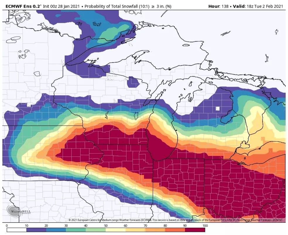
06z EPS expanded the areal coverage of 6"+ probs versus its previous 3 runs. Higher than normal confidence continues at this lead. Barring any last minute surprises, which seems unlikely, we'll be going with a warning this afternoon. While our far southern CWA could have ptype issue and less snow, think chances are decreasing that they don't get several hours of heavy snow with the intense warm advection burst. Regarding our snow forecast, felt pretty comfortable with it, even limited WPC QPF slightly 00z-06z in our grids and kept ratio mostly 7-9:1 range, with spots near 10:1. Unlike the last system, it does look like unimpeded Gulf trajectories and very strong moisture transport this time with extreme PWATs for a snow system. Sent from my SM-G965U using Tapatalk
-
Got the technical discussion out. We've been trying out a shorter initial AFD and then doubling back later. Sent from my SM-G965U using Tapatalk
-
The #1 CIPS analog tonight is March 8-9, 1999, which produced 9" at ORD. March 5, 2013 is #6 analog and GHDII is #11. Sent from my SM-G965U using Tapatalk
-
The last recent winter event for the CONUS that had this good agreement in the models at a longer lead time was the December 17th eastern big dog. And wouldn't you know the outlier model for that event was the operational GFS and it was dead wrong. The GFS v16 was right in line with the consensus that ended up being pretty spot on. Sent from my SM-G965U using Tapatalk
-
That's a good point. Even out by me the stuff on the ground really dried out. Sent from my SM-G965U using Tapatalk
-
We didn't verify blizzard conditions on Nov 25-26 2018 storm with much higher winds than this one has progged even taking the top end guidance (the NAMs). We'll probably work it into our messaging the potential for brief whiteout conditions out in open rural areas given the rates and wind, but don't think this will reach blizzard warning criteria. Sent from my SM-G965U using Tapatalk
-
In 10 years or so of posting here I've never been insulted by anyone. Criticism of the forecast comes with the territory; at times can it be slightly unfair? Yes. But other than that we're judged by the content we provide to help others learn and it's important to consider that as a red tagger. We don't get or deserve a pass for too many Banter type posts in a serious forecast discussion.
-
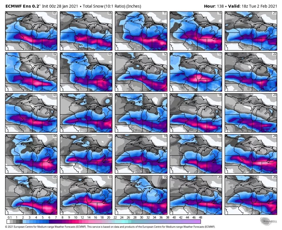
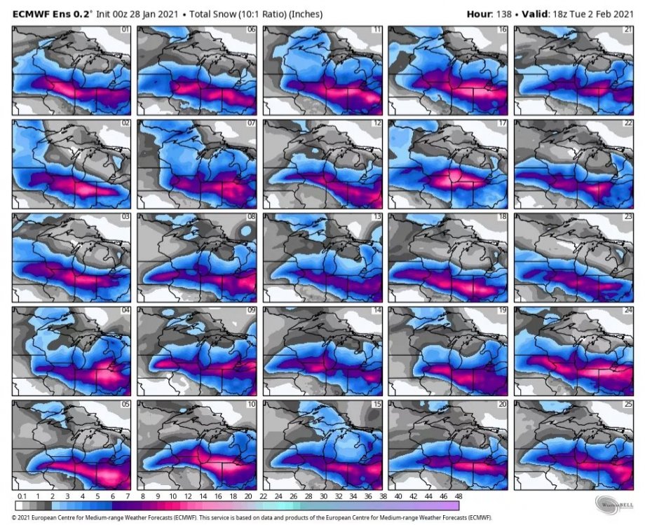
I can post the 18z Euro WeatherBell WeenieVision Kuchera map in Banter. Edit: In seriousness, I do see the possibility of higher ratios something along the lines of what the WxBell map shows for the whole area in a much narrower swath. You don't get that kind of support for heavy rates and big QPF in a short amount of time without having fgen driven mesoscale banding where everything aligns perfectly. In that swath could see ratios let's say in 12-14:1 range. I don't want to make definitive statements until I see everything in depth tonight.
-
Re. our (LOT) snow map, spoke to dayshift forecaster and he toned it down slightly for this issuance because it was a big increase from the midnight shift. Internally, WPC went bigger than the WFOs did. The forecaster (KJB) is one our best with winter weather and he wanted to trend instead of jump with today's issuance. I'm good with that approach. Sent from my SM-G965U using Tapatalk
-
Well I'll gladly step in and be the one to issue the Winter Storm Watch for LOT. My attention is now shifting to how I'm safely going to get to the office for my Saturday night midnight shift lol. As modeled, the support for widespread intense snowfall rates Saturday evening into the overnight looks better than we have seen locally in quite some time. Sent from my SM-G965U using Tapatalk
-
The angle of approach remains key in this setup as it currently looks this far out with respect to how much of a snowpack destroyer/flood setup this becomes in the LOT CWA and surrounding locations with deep high liquid content snow cover. Also the pace of the occlusion process and occluded cold front sweeping through, which will affect the time spent in the warm sector. 12z operational ECMWF is much more ominous in that regard, while the recent runs of the GFS have been much less so. Still finding it hard how we could avoid any rain in that setup, which would need substantial changes in the longwave pattern. Sent from my SM-G965U using Tapatalk
-

Winter 2020-21 Medium/Long Range Discussion
RCNYILWX replied to Hoosier's topic in Lakes/Ohio Valley
Pattern looks prime in the long range (next weekend and beyond) for the central and western subforum. Definitely February 2019 vibes but with a -AO/-NAO. -
I'm not too worried about it as long as the 850 mb low stays south of us. The lower level warm advection and fgen is going to do most of the work Saturday evening into early Sunday AM. During Sunday the system goes vertically stacked and fades east to east southeast so that would continue to keep 850 mb low to the south. Sent from my SM-G965U using Tapatalk
-
True. I think it's the much narrower swath of good totals that's suspect but Chicago looking good still should say something. 10:1 is slightly higher than Pivotal Weather's Kuchera output on that run. Sent from my SM-G965U using Tapatalk
-
It shouldn't be hard to. It's an outlier for a reason, that being garbage thermals. Sent from my SM-G965U using Tapatalk
-
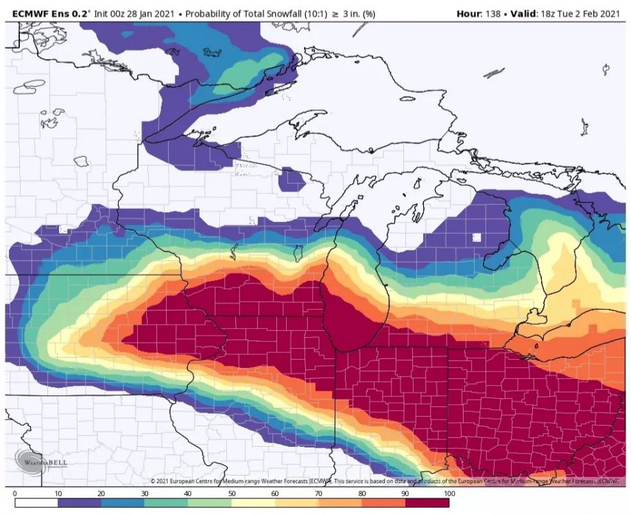
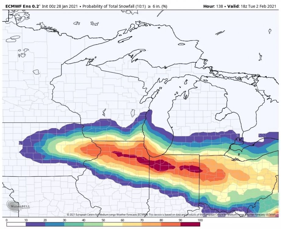
More from the 00z EPS: Individual member snowfall and 3"+ and 6"+ probs [/url]

-
We'll see here shortly with the 00z EPS, if we keep or increase the ensemble clustering, that suggests a stable, higher than average confidence forecast, on top of the overall remarkable consistency of the 00z op models and other ensemble systems. If we keep this up for the model cycles through tomorrow night, I might be the one issuing the watch for LOT, as I'm starting midnight shifts with MTF. Edit: And here it is. The clustering of almost all members within the ensemble mean surface low at 84 hours says it all. While there's still time for changes, hard not to get excited.
-
It's a relatively common occurrence to have a primary in the Midwest and eastern Lakes and transfer to a secondary that blows up near the East Coast. This one is a more interesting evolution I'd say than the more common occurrence. Some of the recent decades big events in the subforum did go on to produce big dog amounts in the east, like January 05, Feb 07, GHD II. What's interesting to me about this one is that the block is over Hudson Bay, which is very far southwest, so it forces that interesting evolution under the block. The cutoff happens south of us on Sunday-Sunday night when it slows down and slides east. Next week's system does have the potential to reshuffle the deck so to speak. It looks like what could happen is the very west based block could give way and then the upper low from the Midwest system could link up with a PV lobe dislodged by a spike of the EPO region ridging. This evolution would then force the block to reorient near Greenland, which is a more classic position for the NAO block and lead to the -EPO, -PNA, -AO, more easterly -NAO, which is a really good look for more fun times ahead.
-
Makes some sense with warmer thermal profile, which tends to shrink the DGZ. Would have to check the soundings though. If the lift is maxed out and well aligned with the DGZ, can get higher ratios than suggested by MaxT from sfc to 500 mb, which is what Kuchera is basically. Also if you have a deep isothermal layer you can get riming and aggregates.
-
Kuchera output for the 00z Euro Sent from my SM-G965U using Tapatalk
-
That's basically the EPS mean track, which also is a good blend of the remainder of the guidance. Sent from my SM-G965U using Tapatalk
-
That I agree with, especially on the operational GFS. I think there's a theoretical northerly limit for the track because of the block but maybe it could nudge a bit more. It depends on location when it tracks northeast and what latitude it ends up because eventually the block causes an easterly phase. It was already mentioned by@Hoosier earlier how this setup with no Hudson Bay block is a wrapped up cutter, which is pretty clearly the case. Sent from my SM-G965U using Tapatalk
-
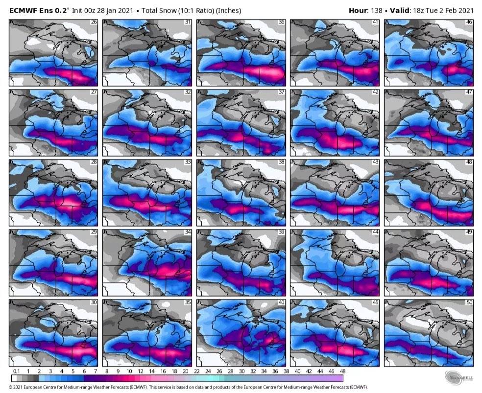
Our friend Kuchie. I'll say it again, the overall agreement in the general details of this system is impressive. Might lend to earlier headline issuance if the run to run consistency continues. Sent from my SM-G965U using Tapatalk
-
Unfortunately it's one of the components of the NBM we use as a common point for the extended. It'll probably be caught and addressed given the consistency and better handle of thermal profile. Sent from my SM-G965U using Tapatalk