

RCNYILWX
-
Posts
3,293 -
Joined
-
Last visited
Content Type
Profiles
Blogs
Forums
American Weather
Media Demo
Store
Gallery
Everything posted by RCNYILWX
-

Pre-Christmas (Dec 21-23rd) Winter Storm
RCNYILWX replied to Chicago Storm's topic in Lakes/Ohio Valley
As much as the high end Kuchera ratios are overdone (24:1+ in western IL/eastern IA on last night's insane 00z GFS), banking on 10:1 ratios is also underdone. With the exception of 1967, Chicago's #2 through #5 snowstorms all relied on above to well above climo (~12:1) ratios. There are red flags in this setup per today's guidance related to the timing of the low rapidly deepening and wrapping up. That said, by far the most reliable NWP we have, the ECMWF, has 1-1.25"+ QPF for the southeast 2/3 of the Chicago metro (and the ECMWF is not known to have a high bias with QPF). If that verifies, then the ratios will easily verify above 10:1. An average of 15:1 would be attainable, and perhaps maxing out at 20:1 in mesoscale banding. The high winds only do so much to lower ratios. Well aligned strong omega with the DGZ, a deep DGZ, and steep lapse rates from the current ECMWF idea would compensate to result in near to above 15:1 ratios. Unless the system ends up well weaker and east of the current ECMWF/EPS consensus (which is possible but a lower probability outcome at time), this will be a very high impact storm. -
Pre-Christmas (Dec 21-23rd) Winter Storm
RCNYILWX replied to Chicago Storm's topic in Lakes/Ohio Valley
Once the GFS jumped strongly to the general idea of the Euro today, it consistently depicted 2-2.5"+ QPF totals in the max swath. Absent lake enhancement, QPF totals like that are very rare in a winter system in the Midwest. As alluded to in my previous post, we saw the GFS do this with both February systems last winter. The 12z ECMWF certainly had a broader swath of high QPF totals than the 00z run tonight, but still those high totals on this side of the lake were in the 1-1.75, locally 2" range. When you have the GFS spitting out obscene QPF and add in the way overdone Kuchera ratios, it creates unrealistic expectations. The 12z ECMWF was probably a realistic best case scenario. -
Pre-Christmas (Dec 21-23rd) Winter Storm
RCNYILWX replied to Chicago Storm's topic in Lakes/Ohio Valley
Because the Euro hasn't changed much from the overall evolution, definitely deserves the most weight in forecast thinking. That's not to say that meaningful changes can't happen, but that the GFS is more grain of salt worthy tonight. Now that the models have honed in on the big picture, not all that surprising the GFS is now the most amped and aggressive with QPF and snow, considering how it handled the February 2022 systems. Sent from my SM-G998U using Tapatalk -
Pre-Christmas (Dec 21-23rd) Winter Storm
RCNYILWX replied to Chicago Storm's topic in Lakes/Ohio Valley
I buy more pronounced wraparound deformation banding than usual given the extreme negative tilt of the system. Wraparound snow is often overdone, but there are rare cases it produces. Sent from my SM-G998U using Tapatalk -
Pre-Christmas (Dec 21-23rd) Winter Storm
RCNYILWX replied to Chicago Storm's topic in Lakes/Ohio Valley
Definitely a plausible outcome for this storm. Sent from my SM-G998U using Tapatalk -
Pre-Christmas (Dec 21-23rd) Winter Storm
RCNYILWX replied to Chicago Storm's topic in Lakes/Ohio Valley
I think Thursday morning is a possibility, depending on how much preemptive cancelations are done so that planes don't get stuck at ORD. Wednesday would be safer. I know for a fact that preemptive cancelations are done for big snowstorms, but exactly when that starts probably varies. I wish I knew for sure, but wondering if flights with no connecting flights after arrival at ORD would be more likely to be canceled early than flights that connect to another airport not long after. Sent from my SM-G998U using Tapatalk -
Pre-Christmas (Dec 21-23rd) Winter Storm
RCNYILWX replied to Chicago Storm's topic in Lakes/Ohio Valley
They (NCEP) may ask for extra RAOB soundings at 06z and 18z. It's pretty common for that to be done before east coast blizzards in addition to always being done before potential landfalling hurricanes. Don't remember if it was done for GHD I and II. Sent from my SM-G998U using Tapatalk -
Pre-Christmas (Dec 21-23rd) Winter Storm
RCNYILWX replied to Chicago Storm's topic in Lakes/Ohio Valley
As currently modeled by the ECMWF and GFS, this storm would be worse than GHD I. The extreme cold in addition to the snow and similar magnitude winds is a game changer. Sent from my SM-G998U using Tapatalk -
Pre-Christmas (Dec 21-23rd) Winter Storm
RCNYILWX replied to Chicago Storm's topic in Lakes/Ohio Valley
If consistency continues on this scenario, we in the NWS are really gonna have to hit the message hard about this being a life threatening blizzard, with incredibly cold temps for a system of this nature. Barring a big change in the evolution, the probability is increasingly high for the main swath to see extreme impacts. That's despite it being mainly a Thursday PM-Friday event. Have to give the overall run to run consistency of the Euro some credence at this point. Sent from my SM-G998U using Tapatalk -
Pre-Christmas (Dec 21-23rd) Winter Storm
RCNYILWX replied to Chicago Storm's topic in Lakes/Ohio Valley
I'd imagine somewhere between 10-15:1 because the DGZ will be deep, offset by the high winds. The Kuchera ratios are definitely way too high because there's no limiting factor with such a cold air mass, and no accounting for the fracturing dendrites by the wind. Sent from my SM-G998U using Tapatalk -
Pre-Christmas (Dec 21-23rd) Winter Storm
RCNYILWX replied to Chicago Storm's topic in Lakes/Ohio Valley
Yep that wasn't any sort of trend toward the other guidance. Small change in the scheme of things and good run to run consistency given the complexity of the setup. Expected more of a shift given how the other guidance really emphasized on the Hudson Bay polar vortex lobe suppressing heights enough to force the storm farther east. The Euro is still letting the main PV (potential vorticity) anomaly/500 mb low do its thing and in this case it was ever so slightly less amped, leading to slightly farther east surface low position over Michigan. As is, high end blizzard for western Lower Michigan and far northwest and north central IN. Out this way, that would be a very high impact storm with warning criteria snow amounts, temps in single digits and winds gusting to 50 mph. -
Pre-Christmas (Dec 21-23rd) Winter Storm
RCNYILWX replied to Chicago Storm's topic in Lakes/Ohio Valley
There's also plenty of amped EPS members along the lines of the 12z UKMET. The overall trend vs. the 12z was again a lean to the west with the lower pressures. This is a high risk, high reward setup. It's interesting that 3 consecutive full Euro runs have nailed this area. As a snow enthusiast, it's fun to see obviously, but less meaningful than it seems given the still large spread among the EPS members. On this side of the lake, probabilities of >=3 and 6 inches favor Wisconsin, northeast IA, and southeast MN more than northern Illinois on the EPS, though have ticked up over the past few runs. Long way to go with this one. If we're allowed to post EPS stuff from WeatherBell or Pivotal, can post some later on. -
Pre-Christmas (Dec 21-23rd) Winter Storm
RCNYILWX replied to Chicago Storm's topic in Lakes/Ohio Valley
Notable changes from the 12z EPS too vs the 00z and 06z runs, whether the changes are improvements depends on where you live in the sub. Def a better look for northern IL. Deeper h5 low and more of a westward lean to the surface low positions. Sent from my SM-G998U using Tapatalk -
Pre-Christmas (Dec 21-23rd) Winter Storm
RCNYILWX replied to Chicago Storm's topic in Lakes/Ohio Valley
. Sent from my SM-G998U using Tapatalk -
Pre-Christmas (Dec 21-23rd) Winter Storm
RCNYILWX replied to Chicago Storm's topic in Lakes/Ohio Valley
Edit: The 12z 12/16 and 00z 12/17 runs of the ECMWF are the wildest back to back model runs for this area since I've been out here. Sent from my SM-G998U using Tapatalk -
Pre-Christmas (Dec 21-23rd) Winter Storm
RCNYILWX replied to Chicago Storm's topic in Lakes/Ohio Valley
That's inaccurate. Just to give two examples, the ECMWF/EPS far outperformed the GFS/GEFS for the February 2022 winter storms. Sent from my SM-G998U using Tapatalk -
Pre-Christmas (Dec 21-23rd) Winter Storm
RCNYILWX replied to Chicago Storm's topic in Lakes/Ohio Valley
The other problem is the GEFS is still too non dispersive to glean much from it when the operational is quite different from the other globals. It's common for ensemble runs to shift in the general direction of the op, but the GEFS hugs closer to the op than the EPS tends to, which does a better job capturing the full spectrum of potential outcomes. Part of that is having only 30 members vs the EPS having 51, though non dispersiveness has been a persistent issue over the years with the GEFS. You can see the issue just comparing the 18z and 00z GEFS. There was a wholesale shift toward the op. Sent from my SM-G998U using Tapatalk -
Pre-Christmas (Dec 21-23rd) Winter Storm
RCNYILWX replied to Chicago Storm's topic in Lakes/Ohio Valley
The 12z EPS is rolling out and the operational ECMWF is the most extreme solution SLP wise that far south vs any of the individual EPS members. EPS did trend more toward the general idea of the operational run vs previous couple EPS cycles though in handling some of the key mid-level features. That 12z Euro run is without exaggeration the wildest non fantasy range model solution for a winter storm in this area that I can recall in my time here (since July 2010). But the first paragraph highlights why these operational runs still need to be taken with a large grain of salt at this lead time. The potential in the pattern next week is certainly high as we've been saying, but the complex evolution will take several more days to resolve. Edit: From the New England sub (where the mood is as you'd expect after the non GFS runs today), look at the change in the ECMWF at the same valid time of 06z Friday 12/13 between the 12z runs yesterday and today. -
Winter 2022/23 Medium/Long Range Discussion
RCNYILWX replied to Chicago Storm's topic in Lakes/Ohio Valley
While we can expect to see rather large run to run swings for a few more days, the modeling of the PV anomaly swinging down from western Canada is pretty consistent on the medium range guidance. The 00z Euro is a (fun) best case scenario, but the anomalously deep upper low plus ridge spike along the west coast suggests digging of that nature being a plausible outcome. Meanwhile a 00z operational GFS like outcome would be a letdown vs the potential in the synoptic pattern, but it still would bring a white Christmas to a large portion of the sub that hasn't had a white Christmas since 2017.- 815 replies
-
- 10
-

-
it's definitely more precarious south of the state line but trending to a realistic scenario for the northern tier. The coldest solutions are even bringing a thump of snow down to a bit south of I-88. Because of the extreme negative tilt of the system, cold advection comes in from the west and the timing of that plus dynamic cooling of the column before the dry slot quickly lifts north and cuts off the heavy precip. Also, the above reason suggests farther inland in northern Illinois would be more favored. The 00z NAM12 and to a bit lesser extent the 3km, basically maxes out the potential in northern Illinois with an earlier and farther south flip. It has support for very heavy snow rates with steep lapse rates through the DGZ (and even some small mucape), impressive omega well aligned with the DGZ, high PWATs and mixing ratios, and a deep isothermal layer at around -8C favorable for aggregates. Given that there is more than just NAM support for a flip to heavy wet snow into northern Illinois, it's becoming more likely but a lot still has to go right to get more than just 1-3" in the far north. That said, it's quite a dynamic setup and generally trending more so, so there could be some surprises in store. The rest of the 00z suite should be interesting. Def looks good for a big chunk of Wisconsin and western lower MI in line for high winds (3km NAM and HRRR showing 60-70 mph gusts over central LM and onto the MI shore.)
- 92 replies
-
- 10
-
-

-
Winter 2022/23 Medium/Long Range Discussion
RCNYILWX replied to Chicago Storm's topic in Lakes/Ohio Valley
Yep, get that pattern within day 10 and it would be surprising to not get a solid event or two. Would think some vigorous clipper/hybrid type systems would be a decent bet too with that look, and those will not be well modeled at extended lead times either. Regarding most recent ensemble runs, both the EPS and GEFS look solid, though would prefer the GEFS because it holds onto positive 500 mb height anomalies in the Mid Atlantic and Northeast. Both ensemble systems indicate the EPO ridge being far enough west to not point toward CAD at this time though as Joe noted it can be a fine line. For the first Decembers since 2016-17, there's hope for winter weather prior to Christmas. Main message is patience and try to stay away from the op runs out beyond day 7-8. Sent from my SM-G998U using Tapatalk -
Winter 2022/23 Medium/Long Range Discussion
RCNYILWX replied to Chicago Storm's topic in Lakes/Ohio Valley
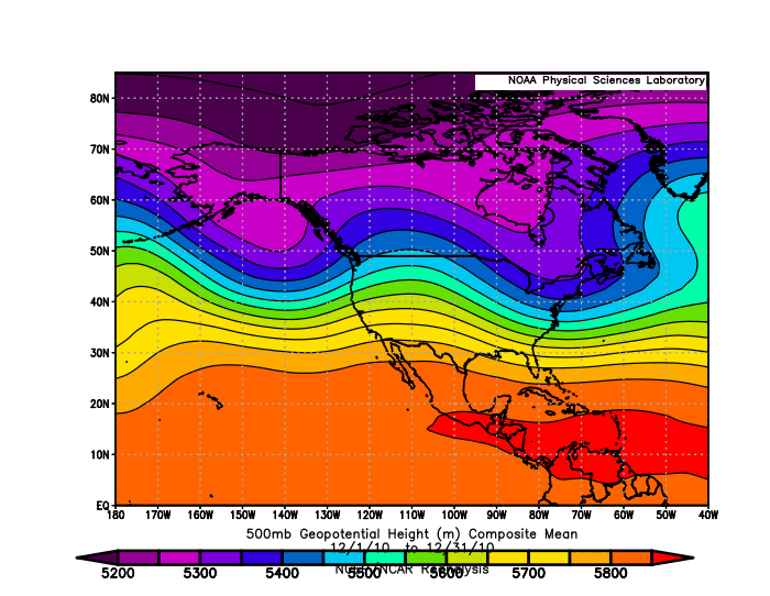
Need a banter thread. Surprised no one posted about the 12z GFS - actual potential in not clown range. But in all seriousness, the 12z GEFS does have an intriguing look later next week, which would fit in the window Joe alluded to on the Medium LR thread. Beyond that, we'll see if things go to a favorable pattern for decent clippers/Pac hybrids. Overnight ENS pointed in that direction. Attached is the composite mean 500 mb heights for December 2010. That had a bigger system (the Metrodome roof crusher) on the 11th-12th then trended to a good clipper pattern through the holidays. It was a Niña with a high end NAO block. We'll see if we have a relatively similar progression this month. The NAO block should have staying power given the forecast magnitude, so if snow can be put down it'll likely stick around. Sent from my SM-G998U using Tapatalk -
Edit: I put this in the Medium LR thread now, but left it here too. Need a banter thread. Surprised no one posted about the 12z GFS - actual potential in not clown range. But in all seriousness, the 12z GEFS does have an intriguing look later next week, which would fit in the window Joe alluded to on the Medium LR thread. Beyond that, we'll see if things go to a favorable pattern for decent clippers/Pac hybrids. Overnight ENS pointed in that direction. Attached is the composite mean 500 mb heights for December 2010. That had a bigger system (the Metrodome roof crusher) on the 11th-12th then trended to a good clipper pattern through the holidays. It was a Niña with a high end NAO block. We'll see if we have a relatively similar progression this month. The NAO block should have staying power given the forecast magnitude, so if snow can be put down it'll likely stick around. Sent from my SM-G998U using Tapatalk
-
A few things are becoming clear for December. Not going to be persistently mild, which is already a change from the last several Decembers. Snow chances are more nebulous, at least through the next 7-10 days. It's clear that the models are struggling with the very progressive and northern stream dominant pattern we're in now. I actually think the retrograding NAO block has some potential to help in that regard. There's some chance for corridors of light-moderate accums in portions of the sub next week but don't expect the models to handle them with solid lead time. Last night's EPS was a step back in the right direction in the day 10-15. Following a brief pseudo +PNA Rockies ridge which may still offer some Pac clipper hybrid type threats, the block connects with the EPO domain block and a signal for lower heights (-PNA) on the west coast toward the end of the run, with neutral heights elsewhere. So basically the connected blocks would allow for a more zonal pattern and not one crushed by the northern stream, plus having sufficiently cold air available due to -EPO/-NAO. Not going to say I'm confident yet in decent event(s) materializing toward and beyond December 10th, but could do worse than the look of the 00z EPS last night. It's a misnomer to think that a big -NAO has to be bad out here. It helped deliver late Jan-Feb 2021. February-March 2013 was another solid stretch of winter weather with a prolonged -NAO. December 2010 was a solid winter month for many with a huge -NAO (Jan was drier and favored EC then the -EPO and -PNA delivered you know what in early Feb 2011. 2009-10 was a very good winter in a moderate El Niño no less with a historically strong NAO block. There's obviously counter examples that mostly benefitted the east coast, such as March 2018, though that did have the late March event for parts of IA and IL. The thing most of us, especially with westward extent, don't want is a big +PNA, which with a -EPO and -NAO would be CAD hell. If you like snow, it not being mild is part of the equation, so we should have that for a good chunk of the month, which we haven't had since 2016 and 2017. Could many of us get skunked? Sure. If I were to bet I'd probably go around normal for ORD (7.7"), which a. shouldn't be that high a bar to clear and b. ORD hasn't had AN December snow since December 2016 and before that previous AN snowfall Decembers were 2013 and 2010. Yikes.
- 274 replies
-
- 12
-
-

-
Winter 2022/23 Lake Effect Snow Thread
RCNYILWX replied to Chicago Storm's topic in Lakes/Ohio Valley
Best in NW IN within the past 10 years was on January 21, 2014 when Griffith area had 20-24" of snow with estimated rates up to 4"/hour. That was the most recent truly high end purely LES event in the LOT CWA. Sent from my SM-G998U using Tapatalk
