

RCNYILWX
-
Posts
3,293 -
Joined
-
Last visited
3 Followers
About RCNYILWX

- Birthday 05/27/1984
-
Thoughts on later today for northern IL and points just nearby: - Locally sky high potential if supercell mode is maintained in the maxed out environment. - There appears to be a play for prefrontal supercells, possibly followed by an intense (likely prolificically tornadic) QLCS. - There also looks to be a play for QLCS being the primary mode, which could yield multiple EF0-1 tornadoes and a few EF2s in addition to corridors of enhanced straight line wind damage. - It seems unlikely we'll get through the event relatively unscathed given the high end parameter space. - Current thinking on most likely area to have a EF2+ tornado (if supercell(s) are there to tap into environment around 21z) is far northern IL (and adjacent southern WI) closer to the forecast surface low and warm front position. Of course neither of these elements are set in stone so a farther south sfc low track and/or warm front position would up the ante for a sig tor threat farther south.
-
Beautiful [emoji854]🫠 Sent from my SM-S936U using Tapatalk
-
The Canadian Rockies had a great winter this year. Base at the top of Sunshine Village and Lake Louise near Banff, AB is about 100" and 90" respectively. Sent from my SM-S936U using Tapatalk
-

Potential Sever Weather Outbreak 4/27/2026
RCNYILWX replied to pen_artist's topic in Lakes/Ohio Valley
Ideally the ENH gets carved out of a large chunk of the LOT CWA. There just isn't enough confidence to warrant it up into the Chicago metro, with the distinct potential for the elevated late AM thru early afternoon convection to force the effective front well south. It would be tough to recover sufficiently for a meaningful severe threat with north and northeastward extent. This looks like a spatially modulated but still higher end setup where substantial air mass recovery is most likely to occur, which appears to be eastern MO eastward into adjacent sections of IL. One of our forecasters at work drew up a reasonable target area for the most appreciable sig tor threat, possibly worthy of a 15% contour. -
From a pattern recognition/climo perspective, it's very difficult to get warning level snowfall into the heart of the Chicago metro with wraparound from a surface low that initially tracks so far NW. The various solutions that have shown a big hit demonstrate that those outcomes are certainly plausible. However, with needing to get the multiple moving parts right, there's plenty of failure modes (as shown by the solutions that keep the big snow out of the metro), and reason to be skeptical locally. Sent from my SM-S936U using Tapatalk
-
It's decidedly a myth that the models are a shit show. The truth is the opposite. If you're wanting truly stable solutions at this lead time for a rapid deepening cyclone, we don't live in that world yet. Sent from my SM-S936U using Tapatalk
-
I was today years old after surveying all day yesterday when finding out about this potential snowstorm/blizzard. March gone wild. Sent from my SM-S936U using Tapatalk
-
What's crazy is that we already had a 5" candidate that would also break the record and then got the 6" report. That's one of the most intense thunderstorms on record in IL. Twice setting new state hail records (likely) with a significant tornado just south of the giant hail. Plains type stuff. Definitely feel for everyone affected down there. Sent from my SM-S936U using Tapatalk
-
Yes, the current record is Minooka, IL on June 10, 2015 at 4.75". I actually happened to be the warning operator that day and took part in the committee with LOT, NCEI, MRCC, and the IL state climatologist to confirm the record. Sent from my SM-S936U using Tapatalk
-
Glad to hear you're okay! Current plan is for me to be on the survey team in southern Kankakee tomorrow. We'll have another team heading into Newton and Jasper. Hope everyone else from the area that posts on the board is alright and no friends or family were significantly affected.
-
Re. the Central Park ob and possibility of officially getting to 20+, hopefully OKX has an agreement with the CPK Conservancy folks who do the measuring to take a measurement once the snow fully comes to a stop. The 6 hour board clearing rule doesn't apply when the accumulating snow ends. For FAA contract observer sites, if the arrangement is the same there as it is out here, we call them for the final measurement when confident there's no more accumulation on the way. Sent from my SM-S936U using Tapatalk
-
As a meteorologist, pet peeve is spelling lightning as lightening, which is most commonly associated with late in pregnancy ha. Keep up the great updates otherwise! Sent from my SM-S936U using Tapatalk
-
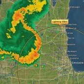
That's radar ground clutter. You can better tell it's an artifact by flipping over to velocity. https://www.noaa.gov/jetstream/anomalous-propagation Sent from my SM-S936U using Tapatalk
-
That's Z time, for Zulu time, which is the same thing as Greenwich Mean Time (GMT). It's the time system used in meteorology and in aviation. 00z in EST(EDT) is 7pm (8pm), 06z is 1am (2am), 12z is 7am (8am), and 18z is 1pm (2pm). Sent from my SM-S936U using Tapatalk
-
No prob! I work and live in the Chicago area (NWS met at WFO Chicago/LOT) but I grew up in Queens in NYC and started my career at OKX. Wish I could be there to experience this one but happy to offer insight to any questions about the storm. Sent from my SM-S936U using Tapatalk


