

iluvsnow
-
Posts
322 -
Joined
-
Last visited
Content Type
Profiles
Blogs
Forums
American Weather
Media Demo
Store
Gallery
Posts posted by iluvsnow
-
-
BAMWX (Private forecaster out of Indy} moved west central Ohio, including Dayton into the 6 plus inch band about an hour ago. Says the storm is slowing down....bombing sooner...and further East track. Winds will be stronger accordingly.
-
 2
2
-
-
I like to follow Bamwx on Twitter for regional info. They are a private forecasting group out of Indy. They just said there is a long way to go on final solutions for this thing. The huge shift from midnight to noon proves that.
-
1
-
-
It all may end up just digital snow....but just had to do the 18z Kuchera for the end of the week, pre Christmas, storm, per the 18z GFS, a week in advance....ho ho ho!!!!

-
2
-
-
18z GFS is a weenie run that, if true, would be the one we've waited for far too long. Merry Christmas indeed! Now if only.....

-
1
-
-
Still a long way to go on this. With all of the anamolous blocking in North America, the models are doing one crack dance after another. I'm hopeful as there is such an array of players on the field. We are all overdue for a big dog, and I just have a feeing someone's going to get one. Now will it be us, or someone nearby? Stay tuned.....
-
This guy is a troll from way back. Time for mod action. Adds nothing but acrimony.
-
5
-
 1
1
-
-
And Arctic hound temps for days on end after!
-
Man are we due! I'm old enough to remember the snowless (flurries) but bitter Christmas of '83. Bring that plus snow on the ground...now that's bliss!
-
1
-
-
November 12th and we're off.....here comes winter 22'-23'. Let's GO!!!!

-
1
-
-
I am submitting dibs on the first witnessed snow of the new season. We are in far NW Montana at Glacier National Park and on our very early morning hike to Hidden Lake at 6,000 feet there was a dusting of snow on the boardwalk at the trail head. This is Mrs. I Love Snow trying not to slip. She, is not a snow and cold fan...thus the scowl on her face. We must endure what we must endure. True I cheated, but I claim first snow of the 2002-2003 winter season.


-
11
-
-
-
Almost a carbon copy set up with a huge swath of freezing rain/sleet preceding copious amounts of snow....all for the same areas as last storm. It'll change by 18z....too far out to get worked up....yet.
-
Sotheast burbs Dayton....all out snowstorm. Boys....this one is worth the wait!
-
1
-
-
Now half snow/half sleet....and cranking SE Dayton burbs as of 3:30. Yea! Check....that....mostly big flakeage!
-
2
-
-
Well.....some good news with the whines here in Bellbrook....snow starting to mix in with heavy sleet here at 2:20 P
-
And in Southeast Dayton burbs....the sleet just keeps pounding......
-
Brother in Greenwood, IN....south of Indianapolis....just shoveled 4" of snow from just this
 AM.....here's how it looks there....
-
On the Wunderground precip/type maps you can see a notch of sleet has been steady up in to the central and eastern parts of Dayton on south....but just SW there is an area of snow. EE's ob confirms this. If you put the map in motion, you see the sleet line actually pushing north...especially in Southern Indiana. Certainly a battle going on upstairs. Earlier the IND weather discussion mentioned that ILN reported a 4+ upper air warm nose over their ob site.
Truth be known...while I love heavy blowing snow....one of my other fascinations is watching sleet gradually transition to snow. Hopefully that happens sooner, rather than later.
-
The noon HRRR keeps the sleet/snow line....virtually unmoved for the next 8 hours before slowly sinking SE. Here it is 8 hours down the line....

-
EE....for once....I hope the NWS is right....not sure what they are seeing....but the HRRR is pretty insistent on keeping us in the sleet sheet lol
-
All sleet here in Bellbrook. Freezing rain initially. The short range models for us want to keep it all sleet virtually all day. Not the way we wanted it to play out. Long train of moisture. Models (HRRR, Nam, etc. don't switch to snow till this evening....however it has it then snowing, hard initially, then moderately well into Friday evening. If only could get the snow sleet line to push south another 15 miles or so.
-
32 minutes ago, HighTechEE said:
Yea 20 miles north or south is big deal with this one in our neck of the woods!
That matrix of data is GFS, but it's not noted anywhere on this page, I have this one for area code 45305 (Bellbrook) and the one for KDAY is obviously much different: MeteoStar Home > Forecast > Bellbrook, OH The 12z is about exactly the same as the 06z where the column goes below 0C and stays there at 06z (1am here) while 1.4" of liquid equivalent still falls for the duration of the 2nd wave.
BTW anyone get a load of the 12z GFS 384 eye candy map of KDAY getting over 4ft of snow the next two weeks! Boy and girls this is a new record!!!

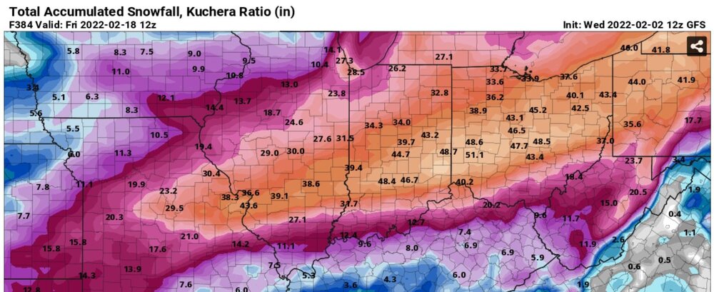
Thanks EE. Keep the fingers crossed. If 1/6th of that happened....we'd have something to tell our grandkids some day.
-
GFS at noon, so far, looks a hair further south with the sleet/snow line....but that just may be my bad eyes. EE, please replicate your column temp forecast chart for the noon GFS run, when its available. Maybe it snows mostly in Kables Mill and Eagle Rise and sleets in Waynesville

-
Concur on the HRRR looking better. Of course it depends on where you live. Kinda like whistling Johnny Cash....(I Walk the Line)


Let’s talk weather!
in Lakes/Ohio Valley
Posted
18z Kuchera HRRR snowfall totals. 10 to 1 about half this. With the cold and dryness...let's hope Kuchera is more accurate