

iluvsnow
-
Posts
347 -
Joined
-
Last visited
Content Type
Profiles
Blogs
Forums
American Weather
Media Demo
Store
Gallery
Posts posted by iluvsnow
-
-
Ended up with about 4 inches in Bellbrook. A mighty satisfying 7 day period. The year after year of no snow has ended. But like crack addicts, you always want more. lol
-
A weenie dream come true.....snow on snow. Also about 3 additional inches on top of last Sunday/Monday's 10 inch accretion. Pinch me....is this real?
-
 4
4
-
-
Here in Bellbrook, just finished shoveling. Would guess 8 to 10 inches....as there was a lot of blowing and drifting. Not a wet snow...but it was very dense as can be attested to by my aching back.
.thumb.jpg.279955c677b5fa22be995d8b733fa424.jpg)
-
4
-
-
We live 15 miles SE of Dayton downtown, and our point forecast is for a total of 6 to 11. We will see.
-
Following up on EE's post...been snowing steadily for an hour....and gradually getting more intense. We already had an inch of snow on the ground from the clipper early this past week. Wasn't supposed to start here in earnest until after 3.
-
1
-
-
Here's some eye candy from BAMWX Saturday morning. I think I'm hypoglycemic.
-
1 hour ago, buckeye said:
definitely been awhile. Even better question might be when was the last time we had maps like this inside 72-84 hours that actually panned out?
This might be that once in an eon when cats lay down with dogs, and the model gods say...."you I-70 plebs have suffered enough....here's a foot of heaven for you....now go away and don't come back for another decade or two."
-
 1
1
-
-
Been following, but no hype till closer. We know what happens when one gets psyched too soon.
-
2 hours ago, Carvers Gap said:
There are a few runs where I maybe say...that might be right on the edge of what I don't want to see from winter. That is flirting with it. Ice followed by that type of cold would be rough. That is a 5 day map. It is at a range that is probably going to change as it is d10-15(plenty of cold inside of d10!). 34 degree departures over 5 days is incredible. The concern is multiple models are showing this type of cold at one time or another. Normally, I would just do a forum accums map. However, I know we have some Midwest folks who drop in, so I will widen the scope a bit.
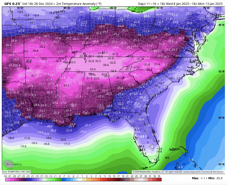
Yep....in Ohio and reading your forum tonight is better than any John Grisham novel. Unlike his posits.I hope it's true.....total weather porn!
-
1
-
1
-
 1
1
-
-
Seems that BAM has said all along that the last week of December would be warm...so no surprise. The tell will be if it turns cold and stormy as they predict right after the new year.
From their X page from several days ago....
-
1
-
 1
1
-
-
1 hour ago, Malacka11 said:
This might be my favorite post in however long I've been here
Buckeye may be a landscaper by trade but he has the quickest, best comic wit on here! And ain't even close.
-
1
-
2
-
-
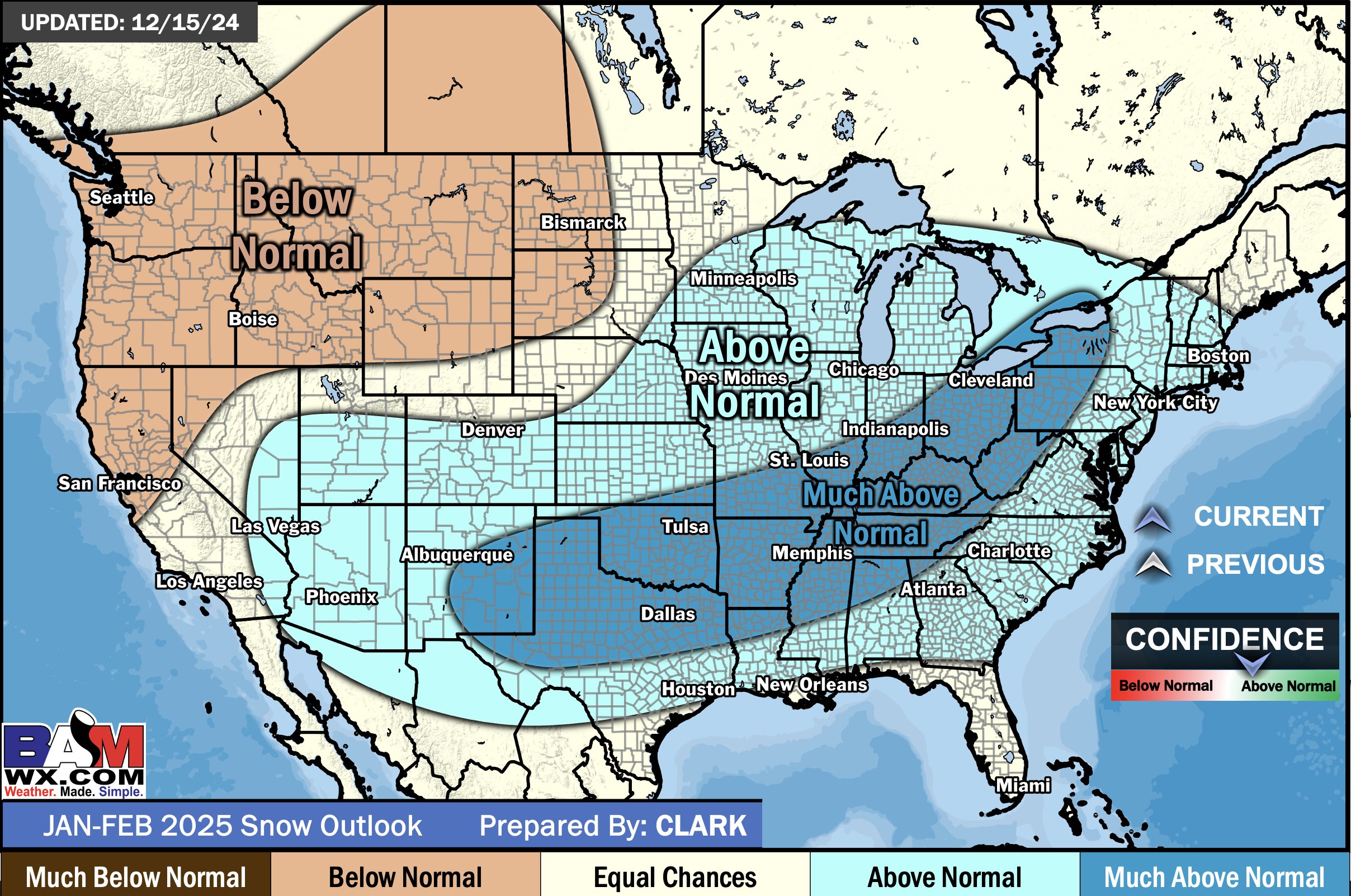
And to put the ultimate hex on snow for we weenies, BAMWX's updated snow forecast for Jan/Feb.
-
2
-
 3
3
-
 1
1
-
-
Either the kiss of death for snow lovers, or hope springs eternal. Updated this AM (12/15).
-
1
-
1
-
1
-
 1
1
-
-
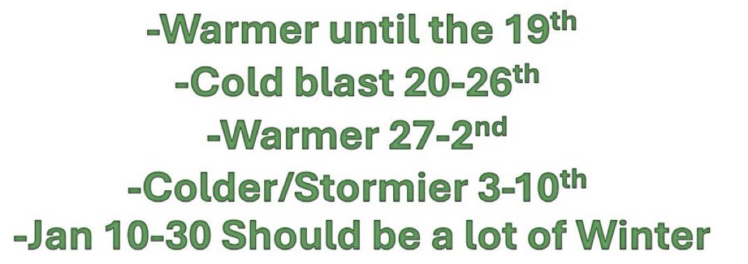
BAMWX with a great technical read on the next 6 weeks. Will we be rockin'
-
1
-
1
-
-
BAMWX with an excellent look ahead, the why and the where:
-
5
-
-
14 minutes ago, DocATL said:
There’s been clipper activity to the north and the south. I know that’s a roll of the dice though. The 19th-22nd look like quick hitters. Cold chasing moisture. A strong quick cold press with suppression and then everything goes quiet. Weird. GEFS ensemble means are paltry and favor LES. All in all December may shake out to BN over all. Many of us outside the snow belt would have preferred a torch.
.Preferred a torch.....uh....no!
-
6
-
 1
1
-
2
-
-
BAMWX update this morning (12/6/24). Winter on halitus until late December or early Jan. But hope for a big winter month to start the new year. Technical discussion. Interesting.
-
1
-
1
-
1
-
-
Interesting look ahead update from BAMWX this morning (12/6/24)
-
1
-
1
-
-
BAMWX CEO Michael Clark with a fresh (12/4) analysis of the month and a half ahead. A technical look at what's driving the coming warm period and what he sees beyond. Take it for what it's worth.
-
1
-
3
-
-
Here's a very good analysis from Michael Clark, CEO of BAMWX this morning (12/4) on what he believes will happen now through January. Excellent technical analysis of what he sees ahead. He gives permission to share across all platforms.
-
5
-
-
For the techno-casters who are trying to figure out what is driving the pending anomalously cold pattern for much of the US, I direct you to a great technical offering from Webberweaher (@webberweather) on X. Pretty interesting stuff.
-
1
-
1
-
-
I love snow here again from the Great Lakes/Ohio Valley forum. You guys remain my go to for real long range analysis for we peons west of the Apps. The orange T means something good may be cooking lol. At any rate, very appreciative of the insight, as our forum is Great Lakes focused (I'm in SW Ohio). They don't get excited unless there's a one or two footer headed for the Chicago area. Keep it up!
-
3
-
1
-
-
And it looks like the CMC caves for the tropical remnants to soak the eastern Ohio Valley. Drought begets drought!
-
This has gotten almost as nerve racking as watching the model runs for snow storms in the winter. Will the remnants of Francine bring much, much needed rain to the eastern Ohio Valley like the CMC says....or be stopped in her tracks by the strengthening upper ridge over the northeast, like the GFS and Euro says. My water bill in Dayton needs the Canadian to score the coup!
.jpg.e83705913230e04b5e6abe55c2dc4104.jpg)

Let’s talk winter!! Ohio and surrounding states!! 24'-25'
in Lakes/Ohio Valley
Posted
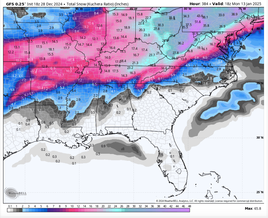
I think this is an all time digital record for snow for Ohio:
https://www.tropicaltidbits.com/analysis/models/gfs/2025020118/gfs_asnow_us_65.png