eaglesin2011
-
Posts
989 -
Joined
-
Last visited
Content Type
Profiles
Blogs
Forums
American Weather
Media Demo
Store
Gallery
Everything posted by eaglesin2011
-
Yep, mixing here in Glen Allen no real surprise... At least the dusting was nice to look at .. saw a few deer's cut through my back woods . Hopefully a nice set up from the next few storms
-
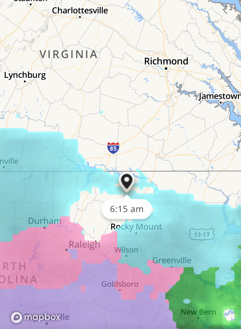
January 16-17, 2022 MLK storm obs/now cast
eaglesin2011 replied to George BM's topic in Mid Atlantic
https://www.star.nesdis.noaa.gov/GOES/conus_band.php?sat=G16&band=15&length=84&dim=undefined Good water vapor loop here too -
Nice steady band about to come in.... Traffic cams and Vcu cam! https://www.weatherbug.com/traffic-cam/?latlng=37.43973,-77.42883 https://ramcam.vcu.edu/cary-street-field.html
-
Yeah, we definitely don't need that.. hopefully the warm air from the coast comes in quicker if that's now excepted
-
Slow/sleet line looks to be around around Lewisville, NC at the moment with my untrained eye.. Gonna be a race now with the warm air racing in from the coast east to west.. Should get some flakes here right about 10Am or shortly after
-
January 16-17, 2022 MLK storm obs/now cast
eaglesin2011 replied to George BM's topic in Mid Atlantic
Good choice.. I actually just went the old school bailey's and Irish whiskey/ whip cream rout... Snow on the doorstep here in Glen Allen,VA hopefully can take advantage of some good rates b4 the changeover down here -
Already flipped in Charlotte & Raleigh NC looks like it had sleet at 26 /27 degrees
-
The backside of the storm could be interesting here if the temps can drop back down in time.. We done pretty well with storms in the past, when it's been able to... Looks like the dry air \screw zone, is already trying to form for our area, on radar ..lol

-
Front end could definitely over preform, the sooner it comes in the better for us.... doubting we will get much wrap around down here but the winds could actually help that happen a bit
-
Next weekend looking better, cold air definitely not looking to be the problem... We will see . Hopefully power stays on for this storm... Looks the winds may become the big story when it really wraps up. Gonna be a crazy few hours from 10-am to around 3ish around here tomorrow.. Then wind into Monday
-
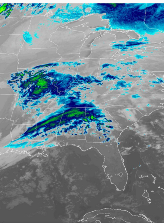
https://www.star.nesdis.noaa.gov/GOES/conus_band.php?sat=G16&band=15&length=84&dim=undefined ^^^Here is a great view of it all "trying" to come together... Models have been basically saying, it won't be able to drop down enough to have enough reinforcing cold air pulled down into the storm in time & phase father southeast.. So, it's why the models are looking so strange with the path & why they are showing more warm air aloft being pulled in and ending up father west...
-
Will be interesting to see how much actual snow we get around here... The sooner it gets here the better. Probably will be a sleet fest for a few hours let's just hope it dosnt start that way .. Definitely gonna be a crazy few hours of weather .. snow / sleet rain /wind .. Definitely could easily over preform (but most likely will be washed away) I was never in on this one at all from the beginning.. Hopefully this is the set up something bigger down the road / maybe around late next weekend or shortly after (at least the cold will be locked in a bit more then)
-
I agree, I don't think it's going to be a flash freeze either but depending on the timing and precip it could get messy for a period of time .. Most likely case right now is snow, to mix, to rain.. How long of each is the unanswered question that remains. Track is going to make all the difference. I personally can see a quick burst of snow then a sleet fest to rain... Being the most likely outcome. Then a possibility of scattered ice on Monday night, for whatever is left remaining on the roads ..
-
I don't think anyone can answer that yet. Depending how much snow /mix to rain we exactly get.. temps will be rising as the storm gets closer.. then drop back down below freezing into Monday night
-
Ummm, That's normally what happens around here..We definitely aren't a snow belt. We are just about half way there to beating last year's total already... lol The end of the month still looks decent, even if we miss out from the next one ..
-
Tend to agree with the snow to rain senecios.. I haven't been a believer in this storm for this area from the beginning. I thought we miss out it.. Hopefully I'm wrong but don't like the sudden shift north.. That's usually the kiss of death for us this early...we will see
-
I'm not even going to look at the models till Friday night.. They seem to all over the place at the moment.. not worth getting worked up about till we are 48hrs out, even that maybe to soon with this one.. GFS Looking like snow to rain at the moment...lol
-
I have been thinking this whole time we would miss out on the next one and that it would set up something bigger down the road .. Guess we will have to wait and see.. Looks like allot of action either way over the next few weeks
-
Another coastal or clipper that misses us that hasn't shown up yet. But again, maybe this could be it?
-
Wonder how much rain / sleet was still showing mixed in the 12z? But yes, Its setting up at really good time if everything sets into place .... I still think appetiser comes through first... Maybe this is it?
-
Better clear I 95 now! Virtual school for the kids for the rest of the winter, (among other things) if that even came close of happing lol
-
Yeah, we may miss out on the next one too but models are showing a sign of a big event around the 18th-25th timeframe.. Still just about 2 weeks away so, it's still fantasy land but more favorable conditions seem to be setting up later this month. Looks like the classic appetizer ( that this area probably will miss out on) followed by a bigger event that maybe cashed in by many .. We will see ... I'll be more excited this time next week, if it's still there.
-
Not helping that the storm is moving in a northeast direction.. Dosnt matter anyway we are still in the 40s Better then getting a severe flash freeze in the morning Prob will still get a little backfill from the ocean moisture later right b4 it pulls away
-
Prob is with the clouds it will be hard to drop quick from here... Gonna need to hit on a heavy band or prob will be just a dusting for most around here Still sitting at 41 in my part of Glen Allen
-
Well clouds starting to overtake a bit more... Max temp looks to be maxing out about mid 50s.. 54 here at the moment