

MD Snow
-
Posts
1,875 -
Joined
-
Last visited
Content Type
Profiles
Blogs
Forums
American Weather
Media Demo
Store
Gallery
Everything posted by MD Snow
-
Feb Long Range Discussion (Day 3 and beyond) - MERGED
MD Snow replied to WinterWxLuvr's topic in Mid Atlantic
Icon with a little snow to start on Thursday. -
Feb Long Range Discussion (Day 3 and beyond) - MERGED
MD Snow replied to WinterWxLuvr's topic in Mid Atlantic
Not sure how many people are writing off the next 12 days. Last I checked models don't really lock in on things outside 5 days/120 hours. Many on here have already punted everything up until Jan. 25. Sure there are things working against us...like the SE ridge not allowing for things to amplify or to much blocking etc. But the truth is that we still have a lot going for us in the current pattern. We could easily score from a weak somewhat suppressed wave in the next 10 days. I see a little potential in the wave next Wednesday making it over the mountains as it gets closer. Also, next Friday still has potential. -
A couple thoughts on the upcoming pattern: 1. I wouldn't be surprised if areas north and west of 95 see at least some snow tv on Saturday and on Monday with the clipper. 2. At this point, it appears that our threat at the end of next week will be running the gradient. The question becomes will we be on the snowy side or the rainy side of that gradient. 3. After that it's up in the air given it's still 10 days out. I'm not counting on anything. However, it would appear, based on ens guidance, that the SE ridge retrogates to the SW, setting up our best look yet. Will that happen? Sure would be nice. Let's see if that look moves up in time or if the SE ridge decides to stick around.
-
Does the storm really cut though? The blocking overtop pretty much keeps it on a west to east trejectory once it forms in the midwest. Just a little too far north from the get go to do us any good. If that low is in kentucky instead of Indiana/ohio we would get a transfer along the nc/va coast which could possibly put us in the game we would also most likely get a nice front end thump. Lots of options still on the table.
-
Yeah, even with the terrible track on the GFS it's still ice to drizzle to dry slot. Shows you what a block can do. Still in the game. Big threat window is still open imo.
-
As others have mentioned, 18z GFS still pointing to January 18-20 as a threat window. That's all you should take from an op run past 200+ hrs.
-
Sorry, don't have access to maps to long range maps. I'm guessing this is in the uber long range - 10 day+? We would still have a bit of a window if what the EPS is hinting at played out, correct?
-
Also, I think the reason the cities haven't had any real snow is not because of some new normal. I think it's just been a ridiculous amount of bad luck so far. I know that's not a scientific answer. However, it is snowing in areas of Tennessee, Kentucky, North Carolina and Virginia today. Yes, even in this crap airmass. We just haven't had any real threats recently and the one's we've had have literally been 50-100 miles away from being huge hits. This line of thinking has kind of kept me sane over the past couple winters. At some point, we will get lucky. At some point we will get the big dog. Until then I try to be at peace that I live just south of Baltimore near the bay and any snow I receive is a bonus and not a guarantee.
-
One issue in this setup is that there is a HPC centered off VA beach and OBX with a disturbance in SE canada. Flip that setup and we'd be in a good spot. The only way I see next weeks threat working out for someone in our area would be a super amped system. Anything less than that is going to be light rain with a little wet snow mixed in at best. Also, imo the super amped solution would favor elevation and areas NW given the current airmass. Models for the most part have been pretty locked in from 96 hrs to the event. I'll have a hard time giving this threat much time without some major changes showing up in guidance by this afternoon and tonight
-
ICON is a classic miller B screw job for late next week.
-
I wouldn't put too much stock in the GFS right now. Seems to be struggling on how it is handling the blocking in the extended.
-
12z ICON looks encouraging at the end of it's run for next weekend.
-
Not according to the GEM. Oklahoma/Kansas snowstorm. Totally different evolution than GFS. Screws our chances of any coastal development on Jan 3-4.
-
Imo, we have two opportunities for wintry precip over the next 9 days. There's a chance the new years system changes over as it heads out, especially for northern and western areas. And there does seem like a window in the pattern for a coastal next Sunday/Monday before the trough builds into the western US. This appears to lead to a brief warm period before possibly a good pattern sets in for middle to end of January. This is based off the super long range guidance which isn't always the most dependable. Another thing, I get the whole decent pattern with no real cold around...but if there was a time we could score with limited cold it would be in January.
-
Both the 18z 12k and 3k Nam have mood flakes for eastern areas Sunday afternoon.
-
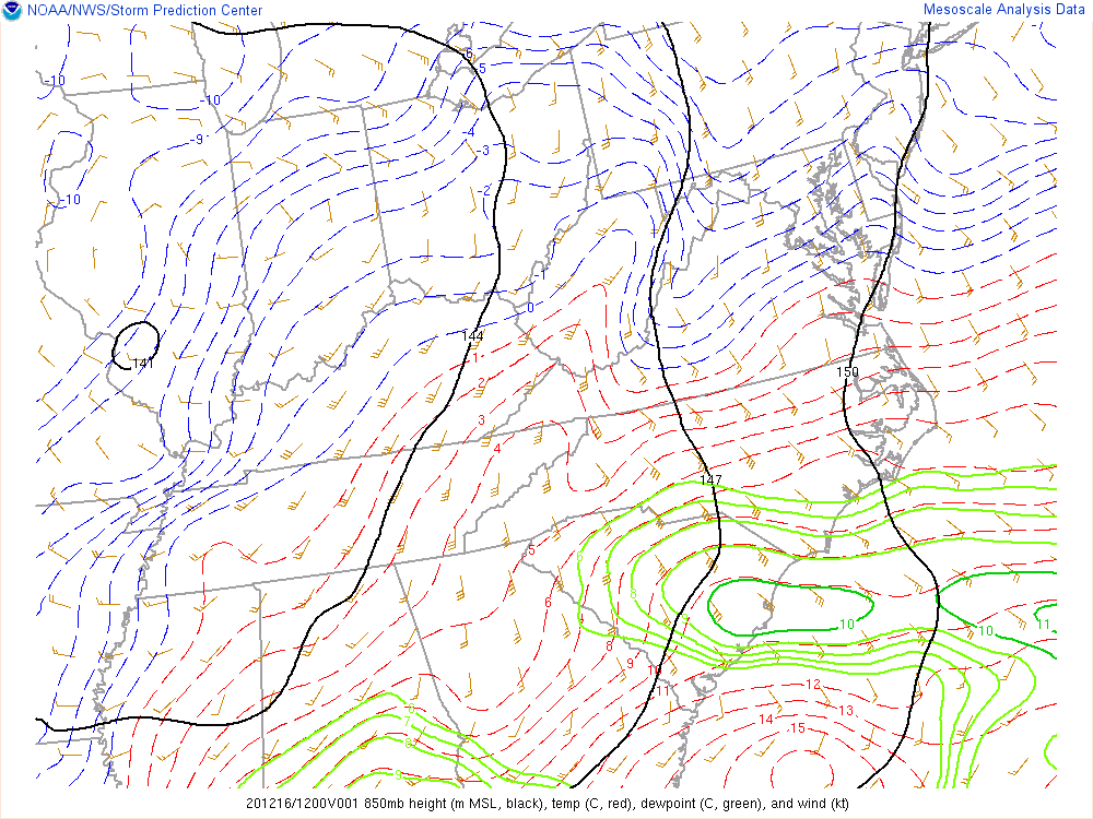
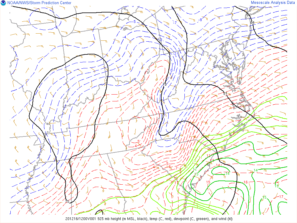
Current 850 and 925 mb temperatures
-
Yes. Even saw the 6z GEFS with some inland runners for the first time in a while.
-
It doesn't account for frozen. Any sleet or zr is shown as rain.
-
FWIW the ICON never gets the cities above freezing for the storm.
-
IMO EURO went towards the GFS. Starting to get a better handle on confluence and the HPC. Still a lot of time for things to shift but I think we've seen the extent of the west trend. Model's could very well be underestimating the high to the north. There's no way the precip shield gets as far north as some of these model's - CMC, ICON etc have it - with a 1038 HPC in southern quebec.
-
Just a few thoughts... I think the GFS is starting to pick up/respond to the strength of the confluence and HP. The northern extent of the precip has decreased the last couple runs across the op and ensembles. 12z screwed the NE. This is because a 1038hp center is no laughing matter and means business. How many times have we said that CAD often times becomes more pronounced in the final 72hrs. Could the GFS be starting to pick up on this? If the 12z op GFS is correct places like BWI will mix but I doubt they lose the surface for the duration. The GFS is a front end thump for the cities followed by sleet/snow mix followed by a classic CCB dump. This is something to monitor over the next 24-36hrs.
-
No...
-
The GFS and Euro moved toward the ICON’s solution today. So 2020...
-
Agreed but it's 18z run was the same if not worse than it's 12z run. Also, having the primary in Indiana and Ohio isn't going help us.
-
FWIW the ICON has consistently been the warmest and furthest West with the LP track of all the globals. Is it on to something?


