

powderfreak
-
Posts
77,033 -
Joined
-
Last visited
Content Type
Profiles
Blogs
Forums
American Weather
Media Demo
Store
Gallery
Posts posted by powderfreak
-
-
13 minutes ago, dendrite said:
The 5 min obs are 1 min obs every 5 minutes...they're still part of the 5 min running mean. Trust them. They're real.
Here’s a RadarScope question for you…
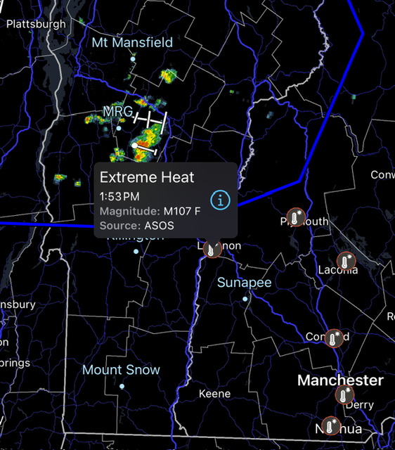
Why do all the RadarScope temperature observations seem way off? Any idea? They are much higher than ambient temp but yet lower than the HI.
It has LEB at 107F, CON 104F, etc. But the HI are higher than that, and max temps lower?
-
Just now, dendrite said:
Those are official 1min obs. So 38C (100.4 converted) is a guaranteed 100F
What are 5-minute ones you see on these pages?
I always get this stuff confused. I’m with Jerry in not trusting the 5-min data spikes. But where are the official 1-min obs?
-
6 minutes ago, Prismshine Productions said:
me, ineedwienies, you... who else
A lot of people enjoy all seasons.
The novelty of big heat and big cold are both fun to see.
-
 2
2
-
 1
1
-
-
9 minutes ago, Torch Tiger said:
sitting out for a half-hour in carhartts and two layers/flannel, whew! breathaking in the best way possible! Going back out, so perfect outside
Good lord dude lol.
-
 1
1
-
-
Just now, dendrite said:
Check out that temp jump/dew drop when the wind flipped W over 20mph.
https://mesowest.utah.edu/cgi-bin/droman/meso_base_dyn.cgi?stn=KPBG&time=GMT
Yeah super cool. Impressive but awesome mesoscale stuff that makes thermodynamic sense. Just mixed it right out coming down the Adk east slope into the Champlain Valley.
-
Check out Plattsburgh (PBG) across the Lake from BTV… first 100F reading in 50 years.
However, the most
impressive thing so far is that Plattsburgh reached 100 degrees, the
first time in exactly 50 years.
They must be downsloping and mixing out off the east slope of the Adirondacks.
They were 91/75… then something happened and they shot up to 100/65. Lost the dews but gained the temperature.
Heat index remained about the same in the 102-104F range.
-
3
-
-
3 minutes ago, dryslot said:
My truck's thermo is so inaccurate, It runs 4-5°F to warm, I guess if you go with its bias you can guess close to actual during travel.
I’ve found mine runs 1-2F warm. Like a 98F, I’m thinking 96-97F.
My old SUV seemed spot on, like oddly spot on with obs. The MVL ASOS is like 100 feet off RT 100 so it was always easy to check when driving by.
-
1
-
-
6 minutes ago, dryslot said:
Car thermos.............lolz
Ha, that I-93 pavement.
Though it matches with KCON at 97/74 in the 5-min data.
-
Just drove past CON on I-93 and the car thermometer was bouncing 95-98F.
Heading to Boston for the night.
-
1
-
-
Getting 88/75s mixed in on the 5-min data at MVL.
Pure Hades.
-
1
-
-
8 minutes ago, dendrite said:
EWR 87° at 11p.

That’s next level, wow.
Anyone without A/C in that area is in trouble. I’m afraid to think that there may be a good deal of folks in high-rise apartments that have no real ability to cool if they don’t have window units?
Imagine starting the first night of the heater with a min in the upper 70s or 80s.
-
27 minutes ago, dendrite said:
I’m getting 1995 nostalgia with the breezy solstice sunsets and 100° days.
Edit…of course last year was similar at the solstice too.
Hope we see some triple digits at key sites. This will be high-end heat and humidity for another couple days regardless of if it hits 100F or not. 95-99F with high dews is uncomfortable enough.
-
2
-
-
37 minutes ago, Damage In Tolland said:
GWDLT
Calm down, you’re like 4 degrees warmer than here
.
BTV is warmer than you at 81F currently. We are in it with ya.
It’s a classic summer evening.
-
1
-
1
-
-
It is so nice out, do not even have the A/C on... just doors wide open. Will likely turn on the dehumidifier function of the mini-split to sleep, but man it is just perfect summer outside right now in the waning light. Still can see outside fine at 9pm without artificial light. It's a whole vibe.
73/68.
-
6
-
 1
1
-
2
-
-
High of 76F so far.
It’s actually impressive it’s gotten that warm with this cloud cover and upslope flow. Any prolong sun will send it off to the races.
-
1
-
-
24 minutes ago, Saguaro said:
Interesting cloud behavior on satellite. They seem to be holding stationary to the north and west of the major mountain divides. BTV and BML say 2600ish ceilings. IZG despite the early clearing still only managing 84 at this hour.
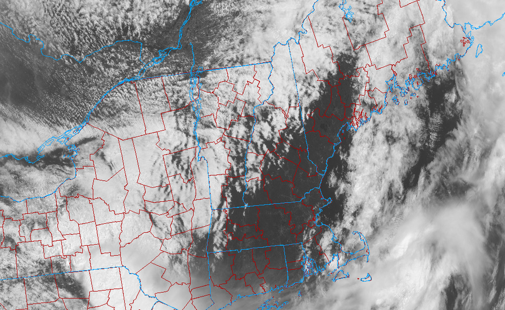
The usual with NW flow blocking things up. We’ve had a few more showers roll through the northern mountains over the past hour.
-
This sounds fun.
* At 849 AM EDT, thunderstorms had produced heavy rain causing flash
  flooding to occur across the Central and Northern portions of
  Chenango County. Between 3 and 5 inches of rain have fallen. Major
  flash flooding is already occurring and being reported across
  Chenango County. Numerous roads and bridges are flooded, as well
  as numerous homes taking on water, especially around Norwich,
  Sherburne, and New Berlin. At least 10 people are stranded due to
  flood waters. Chenango County is in a State of Emergency due to
  the flooding. No unnecessary travel in Chenango County is allowed.
-
Picked up 0.54” of rain this morning to keep the swamps happy.
-
1
-
-
11 minutes ago, dendrite said:
1 run loss! Devers with the GW RBI!
They knew they had to get it within a run. Scored 2 in the 9th just to make it a 1-run loss, and left the tying run at 3rd base.
Poetic.
-
1
-
-
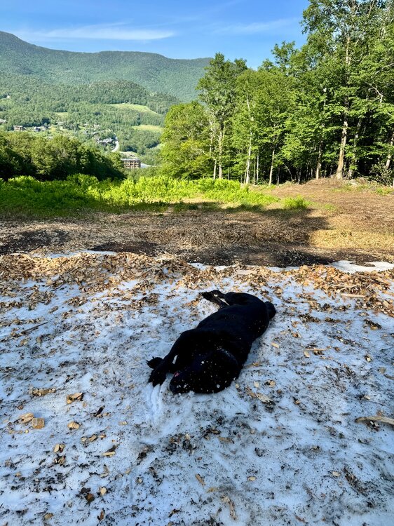
4 hours ago, Prismshine Productions said:
wtf you still got snow up there?!
Yeah snowmaking snow takes a long time to melt. It’s one of the jumps in the terrain park.
Imagine if you had 15 feet of sleet… this is when it would melt lol.
-
3
-
1
-
1
-
-
One last time. The annual post-solstice roll in the snow.
-
5
-
 1
1
-
 1
1
-
1
-
-
Low of 46F… might be the last one like that for a bit.
-
10 minutes ago, HoarfrostHubb said:
I’ll be in NYC Monday and Tuesday. Not looking forward to the heat (and stench)
Good luck. I’ll be in Boston on Monday and Tuesday. Not days to go to the cities.
-
2
-
-
26 minutes ago, weatherwiz said:
All these advisories for heat and here you have winter advisories in Montana and Idaho
Imagine this forecast on the Summer Solstice... Glacier National Park. We can't even get that in January.
Also, yes it is at elevation, but they are going to see snow levels down to like 5,000ft. It's not *that* high up (this point and click is like 6,000ft). Would be like Mount Washington getting plastered on the solstice.
Saturday... Snow. The snow could be heavy at times. High near 31. West southwest wind 15 to 18 mph, with gusts as high as 25 mph. Chance of precipitation is 100%. New snow accumulation of 14 to 20 inches possible.
Saturday Night... Snow. The snow could be heavy at times. Low around 28. West wind 11 to 14 mph becoming north northwest after midnight. Winds could gust as high as 20 mph. Chance of precipitation is 100%. New snow accumulation of 4 to 8 inches possible.
-
4
-


June 2025 Obs/Disco
in New England
Posted
Ahh I missed the time stamp.
@dendrite also scared me as I was like I wasn’t aware I was paying for tier 2 . I was like those sneaky bastards, checking my account lol.