

powderfreak
-
Posts
70,868 -
Joined
-
Last visited
Content Type
Profiles
Blogs
Forums
American Weather
Media Demo
Store
Gallery
Posts posted by powderfreak
-
-
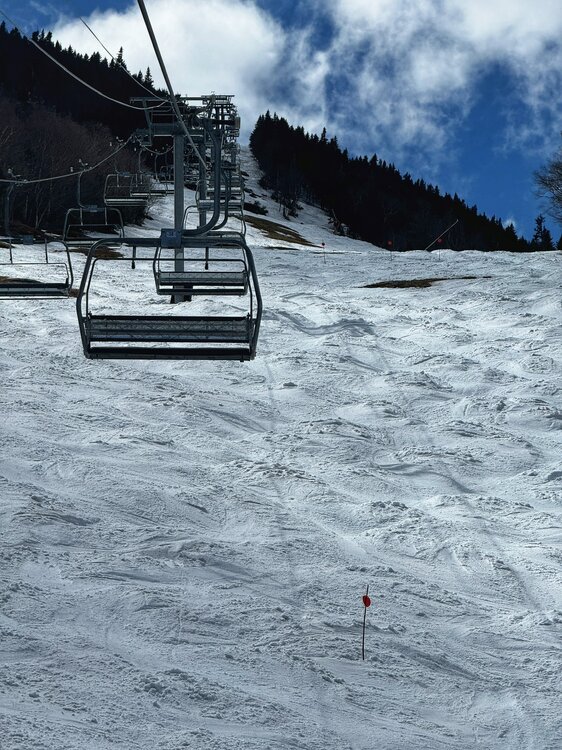
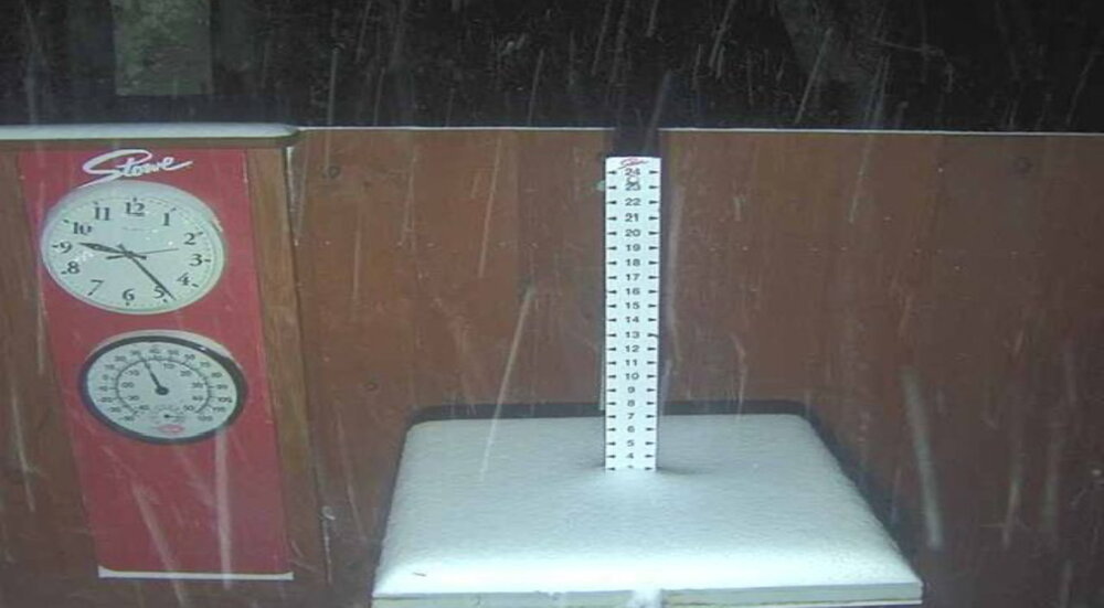
Stowe closed today. For those interested, here is the measured snowfall at 3,000ft. The 4,000 foot elevations certainly had over 300 inches but we measure at a more useful elevation instead of the absolute maximum.
Every inch of this was measured/observed and not estimated. This is what actually fell in a consistent and controlled environment on Mount Mansfield at the upper mid-slope elevation.
November - 35 inches
December - 34 inches
January - 77 inches
February - 42 inches
March - 70 inches
April - 31 inches
Season Total - 289 inches
-
 5
5
-
 2
2
-
-
On 4/19/2024 at 8:12 PM, mreaves said:
I’m in Lake Placid and I came into town past Whiteface. I know it’s the Olympic Mountain so I assume the terrain has to be decently challenging. I don’t much else about it though. Why isn’t it a “bigger” deal? Is it location or are there other reasons that bring it down a bit? Or am I just crazy and it is a big deal for skiers?
It is a big, steep, classic East Coast mountain. It's up there in the top 5 on "big mountain terrain and vertical" in the East, IMO.
What keeps Whiteface from being huge is it's location relative to the populations... there is no easy way to get there except from I-87 in NY. To get to Whiteface, probably 99% of the East Coast skiing population needs to drive past other "big deal" mountains. If you are coming from SNE, you are looking at VT/NH/ME and would have to make a real conscious effort to head to Whiteface.
If Whiteface is located in a different geographic area, it would be a lot more prominent.
Thinking about skier behavior, Whiteface has the vertical and rugged look to be a high-end player, plus it has Lake Placid right there as a fabled tourism town. However, what it doesn't have is snowfall and it is often very cold and windy.
Whiteface does not get the snowfall or consistent snowfall that other northern areas like the northern Greens, Presidentials, and Maine get. Occasionally Whiteface gets a win on a big hugging coastal storm or inland runner. Maybe a rouge lake effect band off of Lake Ontario. But SE synopic flow likes to favor Gore and the southern Adirondacks. Northwest flow favors spots NW of Whiteface. Northeast flow seems to be the best but to get into deep moisture and mid-level lift on NE flow at Whiteface requires a well placed synoptic storm.
I think about why people drive past other ski areas to go to a spot much further away... say Jay Peak. Or Sugarloaf. People do it because of big snowfalls. The northern Greens get dumped on the most on average, so people will travel from the population centers to them. Sunday River and Sugarloaf will develop big snowpacks and get the well-advertised nor'easters. It is harder to find people who will opt to head to the northern Adirondacks over many of these other areas. The market in Albany to Plattsburgh and around the Adirondack Park area is just smaller.
-
1
-
-
3 hours ago, mreaves said:
Just had a few snow flurries. 41.5°
Flurries and light snow off and on today at the mountain. Even making it into town with dry low levels.
Had 1” last night at the mountain, lol.
-
3
-
-
16 minutes ago, kdxken said:
Probably slightly. Still cool for present day climate. I mean heck, last year we had four days in a row of 70s and '80s and even upper 80s.
I guess I look at it differently. Not trying to join the temperature “battle” that seems to go on, but suppose this is inserting myself in the middle, ha.
We just recently in the past few years saw our normals correct higher with the new 30-year-normals… the departures would’ve been even higher less than 5 years ago. We can’t lose sight of the trend line and call moderately above normal as a reason to say it’s “cool” IMO.
Something happens this time of year on the forum where if it’s not record warmth, 70s and 80s, it’s not warm. But in recent months we term it a “warm winter” if temps are above freezing in the means. Those temps are still “cool.”
Shouldn’t we think of “cool” and “warm” as a function of normal year round?
-
44 minutes ago, kdxken said:
Where are the '70s and '80s we've been promised for months? Looks like a cool finish to the month according to my AOL app. Go to Myspace for a complete breakdown.

Isn’t that a slightly above average mean there?
-
Looks like BTV is equal parts warm for max and mins (both 3.5-4F above normal) so not a total nighttime driven month.
It’s just if your monthly mean temp is in the 40s… the difference between 43F and 47F for a mean isn’t really noticeable to most people. Same with say 46F and 50F, despite a solidly AN month. Its still “warm” relative to normal but no one notices.
-
1
-
-
1 hour ago, tunafish said:
Haven't looked to see what's driving this April's departure, but you could argue that if you're not awake at night to experience the departure, it'll still feel cool in an AN month.
It’s also about expectation.
We are supposed to be 54/31 today.
A “warm” April isn’t opening pools up. We’ve seemed to switch to warm season SOP on the forum where it isn’t warm unless it’s shorts and T-shirt weather.
Beginning of the month say is 45/23 up this way… +7 for a high of 52F is going to be “cool” if one expects summer or it’s going to be warm if one expects snow.
Positive/warm departures still can feel cool I guess is what I’m saying depending on what you are expecting.
-
1
-
-
6 hours ago, kdxken said:
Meh, box 1.4 above. It's 47 at night instead of 46. Not opening the pool early...
+4.7 up here for April. Definitely a warm month with +3 to +5 though it feels cool because it wasn’t +8 to +10
 .
.
-
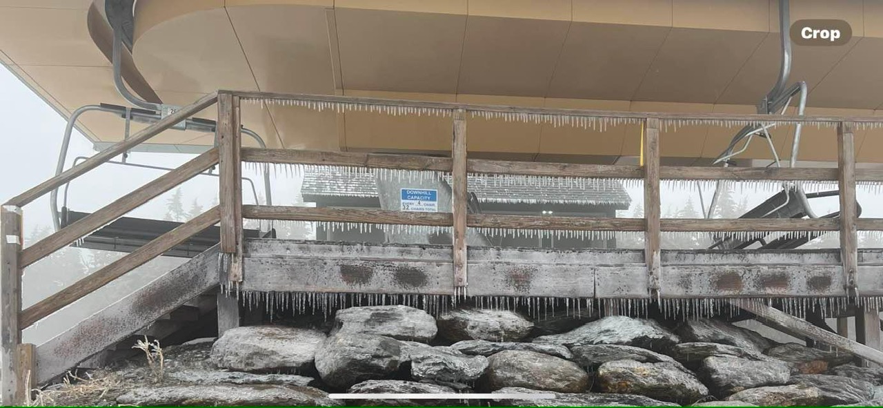
Nothing like an icing event on the mountain when we want spring skiing.

-
4
-
-
Miserable day up here.
29F at the top of the Quad with solid freezing rain.
33F mid-mountain and rain.
36F in the base area and rain.
-
 1
1
-
-
54F up here at MVL for max but with mostly sunny skies it felt pretty nice. Sunshine this time of year makes a huge difference.
-
4 hours ago, tamarack said:
2010 was the earliest here. Unfortunately, 3 straight mid-20s mornings May 11-13 toasted the ash and oak leaves, along with every blossom on our apple trees. Last year was early, too, and many NNE orchards got hammered by the May 18 freeze.
2012 to me was incredibly early.
We then had a major snow at the end of April 2010 with green leaves out… I had 12” at 300ft where I lived in Richmond, VT next to the Winooski River. 1,000ft+ had 18-24”, 3,000ft had 30”.
The early leaf out then snow and cold messed up the vegetation. I don’t know if I remember 2010 being noteworthy early. I’ll have to look back into photos.
-
1
-
-
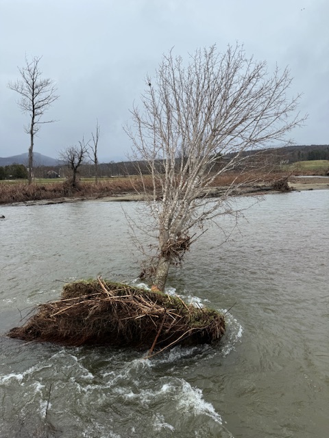
On 4/15/2024 at 9:48 AM, tamarack said:
Sneaky flood - only 1.16" RA plus mountain snowmelt. The Sandy River peaked at 20.9k cfs, which would rank 22nd of 96 water years but was a comparative nothingburger after the 42.7k last December.
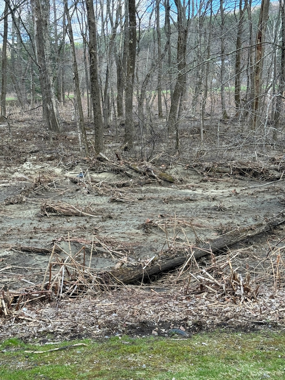
Still finding areas of WTF from the flash flood the other night.
Looking at acres of woods right now just scoured by river water and mud, a long way from the river bed.
I guess this is how water ends up in Alex’s backyard.
Wish this happened during daylight, would’ve been wild to see.

-
2
-
-
Beautiful day.

Time to shut them down though, zero people still skiing, ha.
-
2
-
-
Looks like we did eventually hit 50F in the valley this afternoon. So jealous of the 70s.
-
7 minutes ago, mreaves said:
Overcast and 44.2°. Yay
I still cannot believe we lucked out last Monday for the eclipse. Feels like we’ve seen the sun for just a few hours since then.
Low clouds, cool, drizzle and showers. Ceiling is like 1500-2000ft.
-
2
-
-
Agreed. Don’t care if the grass is torched brown all summer. Or if gardens need daily watering.
Just give us months of dry weather. Anyone who complains about dryness this warm season is a psychopath
. Make it stop.
-
3
-
 1
1
-
-
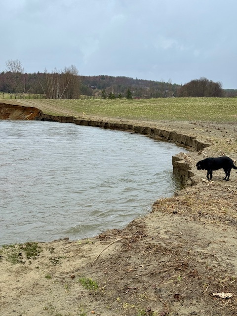
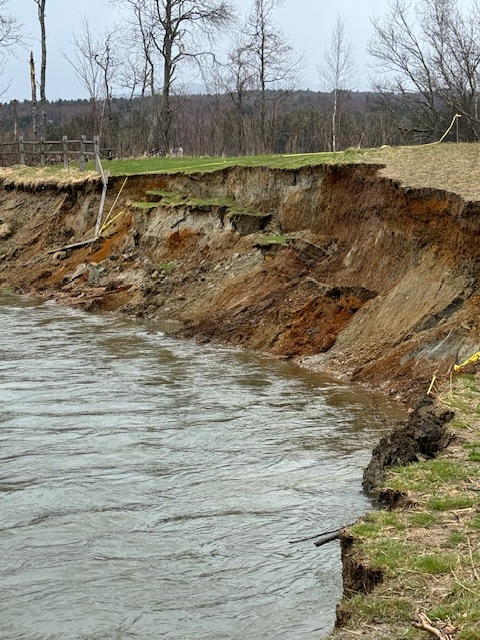
7 minutes ago, CoastalWx said:
Hydro

Funny when it happens overnight and no one sees it as it’s very flashy here… happens fast and recedes fast once done. But it’s like why are their logs out in the soccer fields? huh.
-
2
-
-
Just realizing we had a pretty big flood event the other night here. Walking the dog from home I started noticing logs and trees out in the soccer fields. The river here showing mud deposits like 4-8 feet above where the river is today.
We only got like an inch of rain but the river height looked like 4-6” of rain in major summer flows. Shows how much the mountain snowpack can add to it.

The Dog Path goes through here but it’s now gone as like 40 feet of land disappeared from this field overnight two nights ago.
-
6
-
 2
2
-
-
29 minutes ago, MJO812 said:
Still snow ?
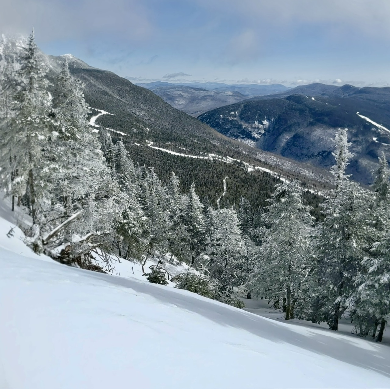
It snowed down through about 1300ft last night.
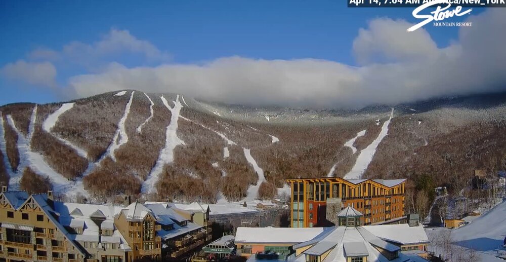
4" up high. 288" on the season and over 5 feet still on the ground. Takes a while to melt off a winter snowpack.

-
10
-
-
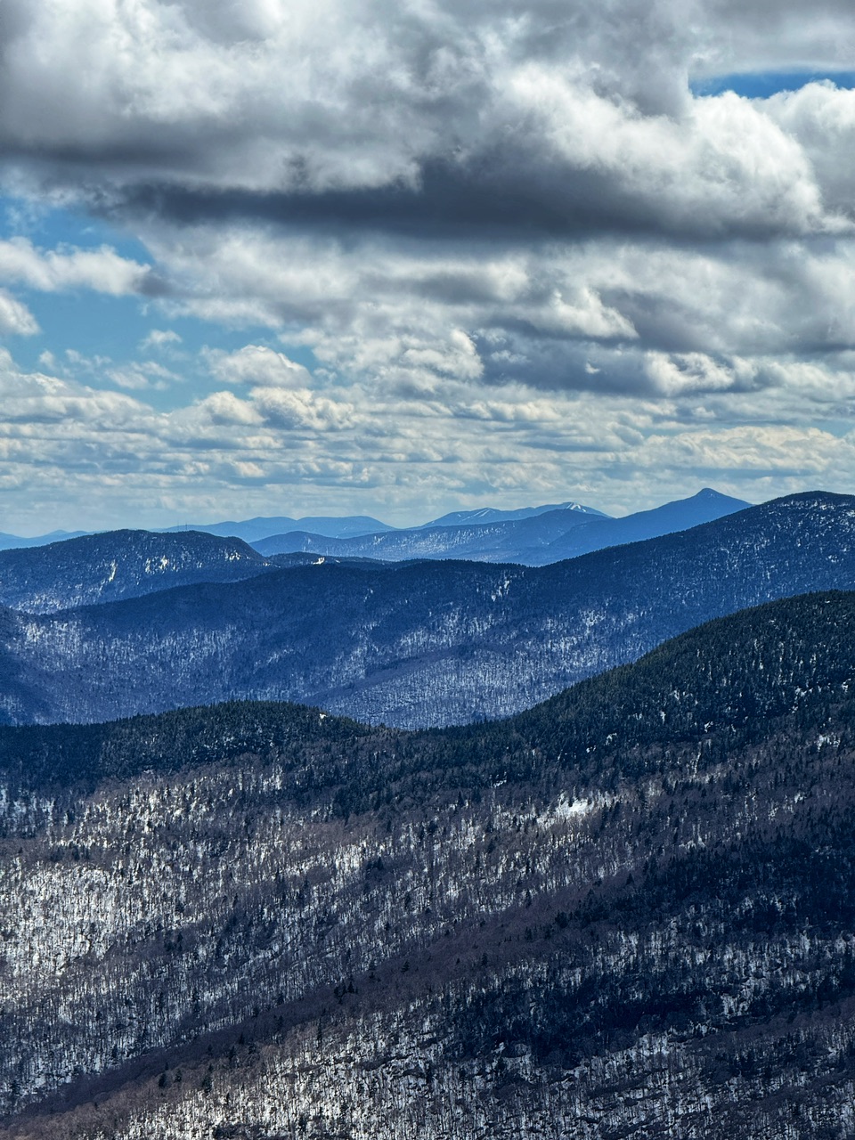
W/NW cyclonic flow on the backside of an upper level H5 trough. 3” so far up at that 3kft elevation. Last accumulation during the operating season?
Puts us past 285” on the season on the mid/upper slope at 3kft. Top of lifts and ridgeline got more. 4kft had to easily clear 300” this season.
-
1
-
-
3 hours ago, eyewall said:
Here is my composite shot from my experience. I used a Seestar S50 to capture these:
Wild. Shows the intersect angle so well. Paths crossing in a once in a lifetime experience.
-
1
-
-
2” at 3,000ft so far. Snow level down to about 1200ft.
-
3
-
-
10 minutes ago, DavisStraight said:
Pics?
lol not of the bear. Just of his shit and trash.

-
3
-


April 2024 Disco- SNE’s favorite month
in New England
Posted
Was this a real question if temps are 32F or lower?