

ChescoWx
-
Posts
9,598 -
Joined
-
Last visited
Content Type
Profiles
Blogs
Forums
American Weather
Media Demo
Store
Gallery
Posts posted by ChescoWx
-
-
Beautiful day both in NW Chesco and down the shore! Splits were 62.1/38.8 in Chesco and 62.6/42.4 in Sea Isle City. Through today in Chesco we are running 4.9 degrees above normal for March. Precipitation wise we are 8.54" or 85% of our normal precip of 10.00" exactly through today


-
 1
1
-
-
I saw some data posted by Adam Joseph from 6 ABC that highlighted the "warming" springs since 1970 at Philadelphia International Airport. I of course could not resist the chance to see what a longer period of raw un-adjusted records back to the 1890's for the 3 longest running Chester County sites might show?Of interest the average temperature changes from the prior decade showed (Coatesville with 6 warmer and 6 colder decades / West Chester 7 colder vs. 5 warmer decades / Phoenixville 6 warmer and 6 colder decades). Overall 2 of the 3 sites show no warming based on trend lines. Of course there can be no doubt that we have been in a warmer cycle since 1970....but failure to show what happened during the prior 7 decades before 1970 may not be painting the most accurate picture. Is climate change real? of course our climate is and will be always changing! But is it simply the normal ebbs and flows of warming vs. cooling cycles? We should never just look at trends since 1970 to make such a call IMHO.

-
Yesterday's 4.3" of snow broke the daily snow Chester County record for March 12th of 2.0" back in 1896. However, we are only at 64% of normal seasonal snow to date.

-
Wife measured 3" with round 1 - I can see on cams it is snowing moderately there again. I have had a travel day from hell. I am still on the plane now and in flight to Tampa. This is my 2nd flight from PHL today. Flight #1 left at 7am and made it about 150 miles south before the pilot got on and said due to a smell (later found to be hydraulic fluid ) was causing him to return to PHL. We landed back in Philly at 8am. We then did not leave on another plane until 130 pm with another 20 min in the deicing line. I should be arriving in Tampa only 7 hours behind schedule...fun times!
-
I am heading out to Phillies Spring Training tomorrow...near record cold in the Clearwater area tomorrow night....upper 30's
-
9 minutes ago, RedSky said:
Daytime snow again 11am to 5pm, March sun angle lol
Sun angle or not - if S+ and upper 20's will accumulate....
-
1 hour ago, MGorse said:
That is a Weather Channel naming thing.

How silly is that?? I have not watch TWC for many years - since they stopped doing weather
-
 1
1
-
-
1 hour ago, anthonyweather said:
This comes on the five year anniversary of Stella

Who or what is Stella??
-
2
-
-
Rain has started to mix with sleet for the first time today here in East Nantmeal. Today's 0.5" of snow is our first measurable snowfall in March this decade! The last time we received measurable snow in March was on March 4, 2019. Of note it snowed each of the 1st 4 days of March in 2019 and we received 11.8" of snow.
-
0.5" of snow so far temp at 32.5 - 5th largest snow of this entire winter!!

-
1
-
-
Temp down to 33.0 snow now much lighter

-
Heavy Wet Snow temp down to 34.7
-
Mix of snow and rain here in East Nantmeal temp at 36.7. I dropped my son off at school - there was no snow at all below 600 feet as the precip started
-
Nearest location is about 80 miles to my SW that reports snow falling is at Raven Rock near Gettysburg at 900 ft ASL
Temp here 38.4 DP 27.0 WB 34.0
-
-
Nice mild but cloudy late winter morning here in East Nantmeal with a Temp up to 38.4
-
East Nantmeal special...book it!

-
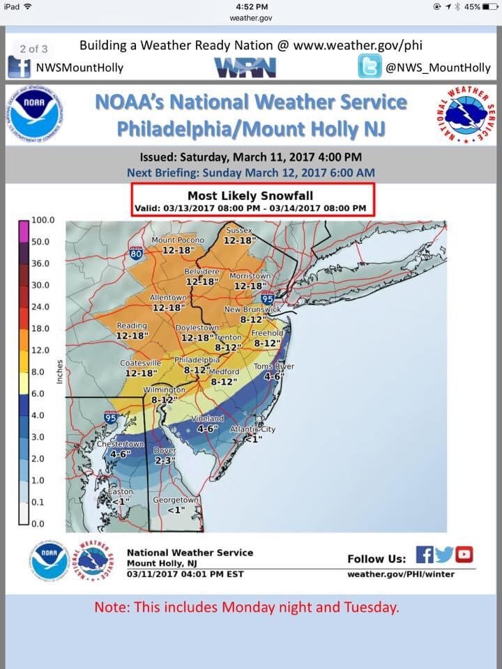
Official NWS Snowcast

-
29 minutes ago, RedSky said:
18z NAM lost a lot of snow
Uh what?

-
1
-
 1
1
-
-
Today's high temperature of 72.4 was the 2nd warmest March 7th behind only 1921
Top 5 previous below
1921 75 1974 72 2009 70.3 1987 69 1946 67 -
High so far here in East Nantmeal has been 72.1 - this is our warmest reading since the 72.8 back on October 25th.
The record for today may be out of reach at 75.0 set back in 1921

-
Locations with elevation over 600ft would if these models are correct see accumulation....if below 400 ft - I would think more white rain
-
2 hours ago, Ralph Wiggum said:
Wednesday AM....white rain:

Above 600 feet would as modeled see some accumulation
-
Some accumulating snow starting to look increasingly likely for some areas on Wednesday....all models have something


E PA/NJ/DE Spring 2022 OBS Thread
in Philadelphia Region
Posted
Storm total of 0.42" so far in East Nantmeal with 0.14" since midnight.