

ChescoWx
-
Posts
9,598 -
Joined
-
Last visited
Content Type
Profiles
Blogs
Forums
American Weather
Media Demo
Store
Gallery
Posts posted by ChescoWx
-
-
AM lows across Chester County ranged from from the mid-40's in valley locations to low 50's on the ridges. Another beautiful day today before more unsettled weather for mid-week. Our record high for today is the sizzling 99 degrees back in 1899, The record low is the 38 degrees in 1958. Record rain is the 2.65" from 1928.

-
Today was in my book a top 10 day - DP dropped into the 30's this PM with high temps across Chesco including: East Nantmeal VP2 73.4 / EN Ambient 73.4/ EN Tempest 76.3 / /KMQS 75.2 /Elverson 77.8 / Marsh Creek 80.8 / West Brandwine Twp 77.3 and Downingtown 76.7
-
Low's last night across the County ranged from the chilly upper 40's in the lower spots to the low 50's on the ridges. Today should be a couple degrees cooler but another beautiful day. Record high for today is the 97 degrees back in 1927. Record low was the 39 degrees reading on this date in 1948. Record rain for the day is the 2.39" on this date in 1970.

-
The Chester County PA weather summary for the recently completed month of May.
Our average temperature was 62.5 (+1.7 above normal) This was the 44th warmest May since records began back in 1894. Of note 4 of the 5 warmest month's of May occurred prior to 1944 with the warmest being the 68.5 average temp in May 1944. Our warmest temp was the 88.3 on the 31st - lowest temp was the 39.1 on the 8th. Rainfall totaled 5.06" which is 0.67" above normal. This was the 36th wettest May. The wettest May was the 11.72" that fell way back in 1894.
-
The record high for today is 95 degrees set way back in 1895. Our record low is the 37 degrees from 1927. Record rainfall is the 3.11" that fell in 1946.
We only picked up 0.06" overnight after missing all the rain yesterday.

-
Still no 90+ days this year in the higher spots of our County as we could do no better than 88.2 yesterday here in East Nantmeal and 89.6 at KMQS Airport in Coatesville. Record High for today is 96.5 way back in 1895. The record coldest was the 34 degrees in 1930. Our record rain for the day is 1.69" from 1977.

-
Plenty of 90's across the low spots of Chesco with Marsh Creek at lake level already up to 96.5 while Hawk Hill in Downingtown up to 89.1 and 89.6 at KMQS and 90.0 at KPTW. Here in East Nantmeal the roof mounted Tempest has topped out at 90.9 degrees - but both the VP2 at 88.3 and the Ambient station (88.2) have not yet topped the 90 degree mark. Also 1st 90+ day on the barrier islands at the Jersey Shore!


-
Already up to 88.5 down at Lake Level on Marsh Creek and up to 84.3 here in East Nantmeal and 85.0 on my tempest roof top station....could we actually touch 90 here in Western Chesco for the first time since June 30, 2021?
-
Records for today - High 94 in 1942 / Low 37 (1961) record rainfall 2.12" (1971)

-
18 minutes ago, CoolHandMike said:
It's almost 5pm and the temperature is still rising. Already 4°F over forecast. 84 right now. At least it's dry-ish?

Think you may need to check your siting or thermometer...no spots across all of PA with the exception of the PHL airport heat islands even got to 82 degrees....

-
11 minutes ago, CoolHandMike said:
It's almost 5pm and the temperature is still rising. Already 4°F over forecast. 84 right now. At least it's dry-ish?
Wow what a difference across most of Chester County with some elevation ...East Nantmeal could do no better than 76.1 and KMQS Chester County Airport only made it to 77.0....you are in a very warm spot...assuming a low elevation in the Reading PA area
-
Beautiful day down the shore in Sea Isle City NJ. Nice breeze off the chilly 62 degree surf temp


-
Our record high Chester County temperature today is the 92 degrees on this date back in 1969. The record low is 35 degrees set back in 1949. Record daily rainfall was the 3.05" that fell back in 1990.

-
We received a total of 0.61" of rain with the storms yesterday and overnight.Our record high temperature for today is 94 degrees set back in 1941. The record low was also the latest freezing temperature in Western Chesco history at 32 degrees this day back in 1927.

-
The record high today is 92 degrees from 1991. Record low 38 degrees in 1926. Daily rainfall record is the 1.92" from 1952.

-
No measurable rain overnight. The record high for today is 91 degrees set in 1964. Our record low is the 30 degree reading today in 1956. Of note that would be the 2nd latest freezing temperature ever recorded in Western Chester County. The latest freezing temp occurred on May 28, 1927 when the low was 32 degrees.

-
14 hours ago, Hurricane Agnes said:
Found the 1888 data. It is in the 1889 Pt. 1 PDF (selectable via a drop-down menu) at NOAA's Signal Corps data at that link - https://library.noaa.gov/Collections/Digital-Docs/Signa-Corps-WB-Annual
Have to scroll down but for example, starting from "pg 254" of Pt. 1, you start to see the individual observer station reports (earlier tables appeared to be the data for full stations that had all the instruments). So the first "Coatesville" reference (just from a quick scan) appears on "pg. 285" (the page number printed on the document) and it appears that the first obs readings started in March of 1888 for monthly/annual mean temp. Then on "pg. 328" are the "max/min/range" temps for Coatesville Mar. - Dec. 1888. Then the piece de resistance - the precip for Mar - Dec. 1888 in Coatesville (doesn't distinguish frozen from liquid, it appears to just be total qpf).
(I blame you for this!


 )
)
You are the best!! I will be diving in to this data....the weenie that I am!!
Thanks again!!
Paul
-
Our record high today is 95 degrees from 1941 - record low temp is the 34 degree today in 1963. Record rainfall is 2.59" from 1915.

-
With the exception of Mount Pocono....almost all spots reached or exceeded 90 degrees today. Of course to no surprise here in East Nantmeal we could NOT reach the 90 degree mark....with the exception of my Tempest weather station which is mounted on my roof (which did reach 90.7 degrees). However my Vantage Pro 2 (which I use for my "official" reports - mounted 5 feet above the ground and my Ambient Weather station also mounted 5 feet above ground level reached 88.1 and 88.0 respectively - I see nearby Bucktown also could do no better than 88.5. No doubt many spots under 600 feet across Chester County reached the 90 degree mark. The Chester County Airport (KMQS) almost exceeded...but topped out at 89.6.
-
2 hours ago, Hurricane Agnes said:
After the meltdown in this thread, I ended up going on a journey back in February, into the history of Coatesville, a place so close but that I really had little background on (other than one of my lab benchmates when I had first started at that job almost 40 years ago, lived there).
I was really surprised that there was an actual steel mill there (that had specialized in rolled and cast parts, and is still there). But the other thing I noticed was that there were several references, including schools, that were named "Gordon" and that started me down the rabbit hole.
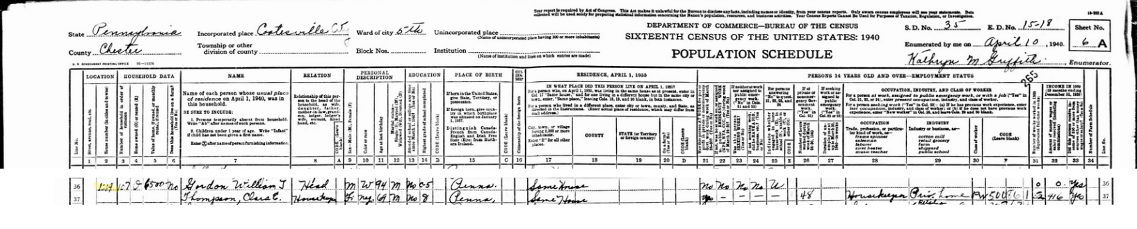
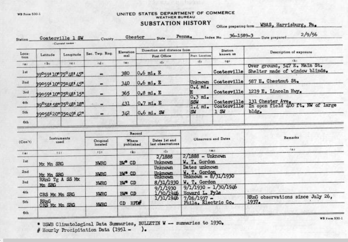
So looking up this name (and knowing when his observer records were done), I stumbled on a 1940 Census entry, took a screen shot snip of the Census page's header and one of the entry with the name, and combined them as a single image (attached). Based on the age listed in 1940 as being "94", that would make his birth year 1846. The address on that entry "1219" corresponded to that page's "E. Lincoln Highway" list of homes. And THAT corresponded with one of the addresses listed for W.T. Gordon for the "Substation History" as enumerated in 1956 (also attached).
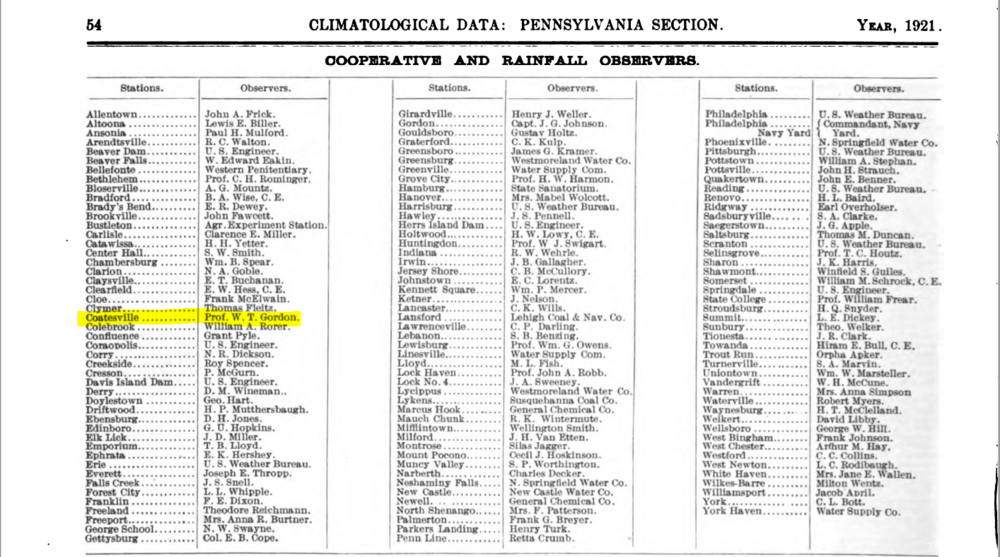
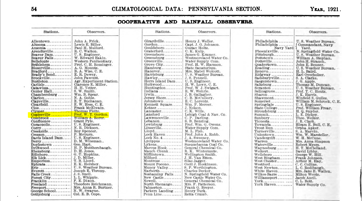
But here is the kicker, and I had to eventually take a break obtaining a "smoking gun" connection, but I also found a 1921 reference to the Climatological Observers that year where his name appears, and it includes the title "Prof." (for "Professor" - the old designation for teachers), and that snapshot is attached.
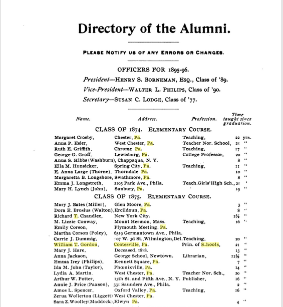
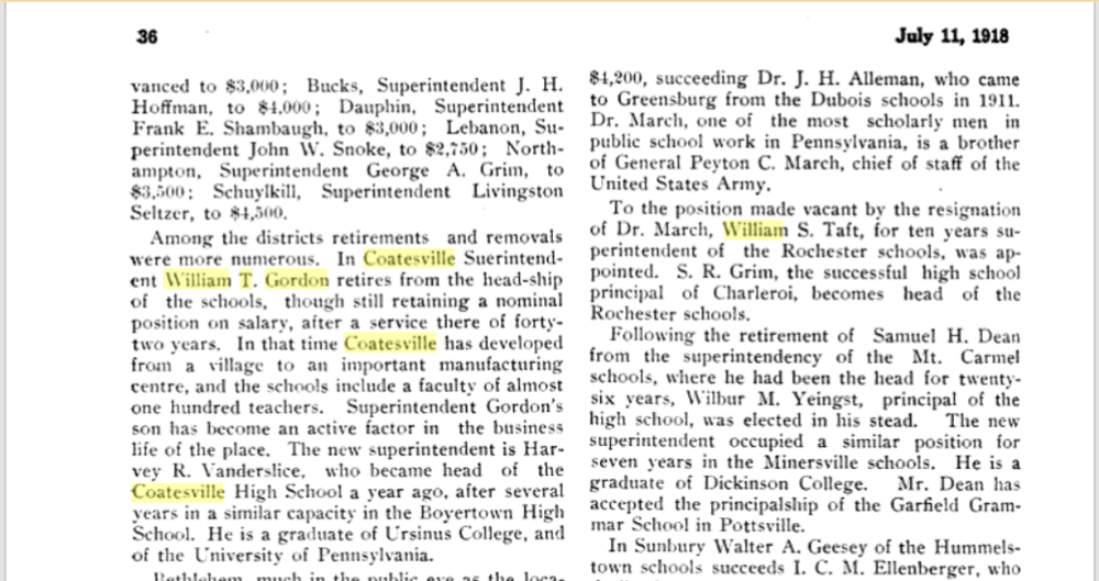
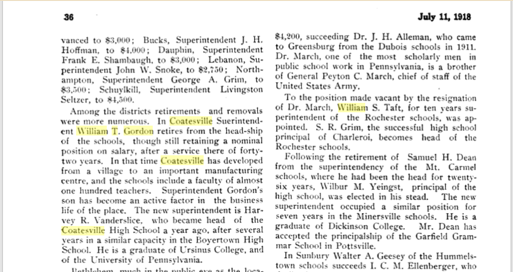
And that sent me back, back into time to find that he graduated from what was then West Chester State Normal School in 1875, which is of course now known as West Chester (State) University (attached) and he was listed in that 1895/1896 Directory of alumni as being "Prin. of Schools" ("Prin" for "Principal"). And this then lead me to one of many vaunted references to his "retirement" in 1918 as "Superintendent of Schools", "after a service there of forty-two years" (attached).
So this "W.T. Gordon" ("William T. Gordon") was appointed "Superintendent of the Coatesville Schools in 1876.
So based on the Observer records, he actually started out as one of the earliest observers when the program first started under the Weather Bureau (under USDA) in the early 1890s.
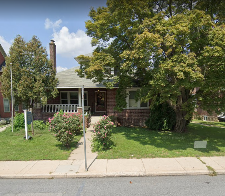
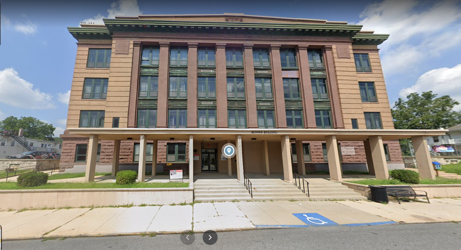
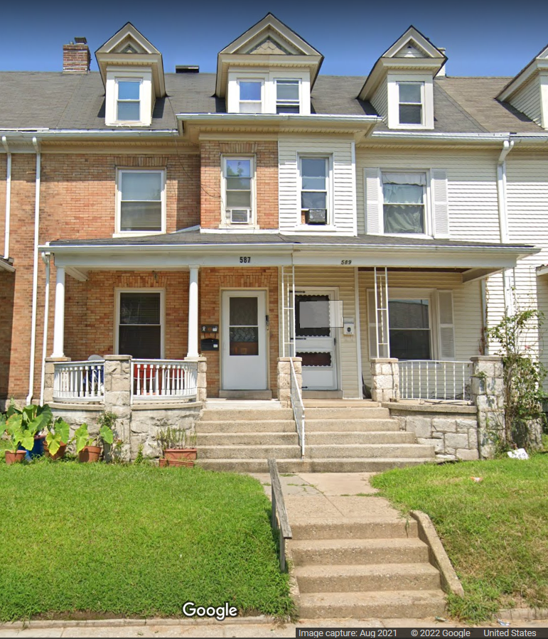
I did some "modern day" screenshots of the observer locations of the 2 houses that were listed (1st was "547 E. Main St." later moving the obs to "567 E. Chestnut St" and 2nd 1218 E. Lincoln Highway") - both attached below. It's probable that different houses were there on those properties back in the late 1800s and through to at least the 1940s when he was still alive, but it was interesting to see nonetheless. Not the first "building" is obviously newish and wasn't there back in the late 1800s but is on the lot where the first obs were done.
Assuming this is all the same guy, it makes perfect since that an educational professional (and Superintendent) who perhaps had this as a hobby, would be so detailed with the records. I wouldn't be surprised if some students may have done readings too... There's quite a bit there about this family (and his sons including one who worked at the steel mill).
So like I said, I went down the rabbit hole and some of it was also due to a guy who has a Facebook page with literally thousands of archival pics of Coatesville from many eras including going back into the 1800s. His page is here - https://www.facebook.com/A-History-of-Coatesville-Pa-Mark-Ford-Webmaster-675536869267910/
(I don't do Facebook but if there are public-accessible parts of a Facebook page like this one, that are interesting, I'll go peruse them and I spent days going through some of the pics that this guy had)


Wow!! this is excellent information that I have never seen!! It appears he was submitting obs back to February 1888! The earliest obs I can find from him are those from January 1894. Will have to do some digging to see if anyway to unearth those additional years! To have tracked daily data for 42 years is mighty impressive. Maybe I can reach that number of years if I am still around!! Thanks for the most excellent research!!! Paul
-
Can we touch 90 here in NW Chesco? My VP is at 86.0 - the rooftop Tempest is at 88.0 and my Ambient station is at 85.3
-
21 minutes ago, Hurricane Agnes said:
Let me go through and gather what I saved in my "electronic folder" on who I believe is him (including some screenshots of stuff). Was debating where to stick it since I am trying to avoid the trolling threads where his name came up, so may want to stick it in one of your other threads.
I kind of miss our obsessive friend from the valley!! Thanks for sharing!!
-
28 minutes ago, Hurricane Agnes said:
You realize you made me go deep down a rabbit hole a few months ago regarding that guy and who I believe he is, resulting in some interesting info (based on census data and township historical docs) but that will be for another day.
Would love to know more about him and the guy that followed him Howard Pyle....let me know! Thanks!
Paul -
Of note we have not had a 90+ day in May since May 3, 2018. In that year we ended with 4 days above 90 that summer. The last time we had earlier 90+ temps (April/May) was on April 26 and 27, 2009. In that summer we never again saw a 90+ day as those 2 were the only times we were able to crack 90 that year and 1 day was 89.5. Before that our last 90 in May was on May 4, 2001.


E PA/NJ/DE Spring 2022 OBS Thread
in Philadelphia Region
Posted
Record high for today is 97 degrees from 1899. The record low is the 42 degrees from 1949. Record rainfall is the 2.94" from back in 2013.