

ChescoWx
-
Posts
7,516 -
Joined
-
Last visited
Content Type
Profiles
Blogs
Forums
American Weather
Media Demo
Store
Gallery
Posts posted by ChescoWx
-
-
Some flurries North of here and also some streamers to the west that might clip NW Chesco later this AM otherwise looks like temps will likely slowly fall later this PM leading to potentially our 1st freezing temp of the season before midnight. If so our growing season will end after lasting 203 days - this is 28 days less than last year and would be our shortest growing season since the 188 days in 2013
-
1st 8 days of November have run +7.1 above average for NW Chester County - should see much of that vanish over the next 10 days with much chillier temps. Point and click from NWS has a high of 51 today...Wxsim says temps stay in the mid-40's. Will side closer to the WXSIM today with rain moving in by early PM with some virga already over the area this AM. Wxsim sees around 2" of rain by midnight tonight. This will continue our progress toward making this the wettest season since NWS Coop records for Chester County began in 1894. We are now only 7.23" away from the record of 75.12" set back in 1996.
-
I am thinking that after our relatively brief turn to well below normal temps next week with the chance of some snow in the air (not accumulating)....I think a near normal Thanksgiving Week followed by an above normal final week of November. With Dec starting w/above normal temps. Really thinking December could open with well above normal temps kind of like 2012 but I don't think the above normal stretch will last as long as that December. More troughing in east by the 10th or so - hopefully in time to support a white Christmas....we can dream can't we?
-
High today 57.2 - today may be one of our last above normal days for the remainder of the month. Increasingly good chance we finish November as the coldest one since 2014. Rain wise exactly 1.00" of rain fell over the last 2 days this brings us up to 2.93" this month and a whopping 37.26" just since July 1st! We are now only 7.23" behind the all-time Chester County record of 75.12" from back in 1996
-
With the 1.93" of rain since last night we have now received 66.89" eclipsing 1979 as the 2nd wettest year in our recorded weather history from 1894 to Present here in Chester County PA. The wettest year in history was 1996 when we recorded 75.12" of rain

-
another 0.80" of rain has fallen here in East Nantmeal in the last 45 minutes bringing our daily rain up to 1.53" so far and still heavy rain. Temperature is down to 56.9
-
9 minutes ago, donsutherland1 said:
As of 10:10 pm, Reading has picked up 1.49" rain. That brings 2018's total precipitation to 56.91". As a result, 2018 surpasses 1972, when 56.85" precipitation, fell to become Reading's 2nd wettest year on record.
Don with our 0.73" so far today in the NW Philly burbs of Chester County Pa we have now recorded 0.73" today which puts our YTD rain/melted snow total at 65.69" with more incoming with the frontal passage over the next hour or so. This places this year at number 3 all-time since our local records began back in 1894. We are now only behind 1996 with 75.12" and 1979 with 66.88" of rain
-
 1
1
-
-
Heavy Rain here in NW Chesco with 0.73" so far today - look like heaviest line still to come through over the next hour or so with the FROPA looks like the cold front is only about 14 miles to my NW so expect temps to drop pretty quickly from the current 65.1 to an almost 10 degree drop over the next 2 hours to the mid to upper 50's Today's high was 68.9 - well above our normal high of 59.7 but well below our all-time high here in Chester County of 82 degrees back in 1982.
-
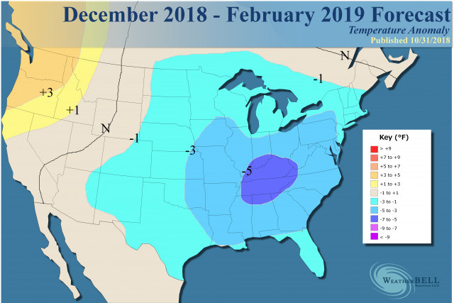
Updated winter forecast from WeatherBell
October 31, 2018
- Evolution to a cold, stormy winter is beginning.
- The most recent closest winters are 2002-03 and 2009-10.
- No change to the man setup first espoused back in August and then late September.
- Forecast made a bit colder for the heart of winter.
- Snowfall map honed a bit.
Snowfall:
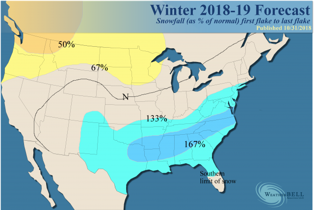
Discussion
The setup for this winter has been dealt with exhaustively in previous forecast packages. There is no use flogging a dead horse, as I am happy with our diagnosis. A new round of modeling will come out starting next week and we have not yet had the Euro do its usual flip-flop, as it has done on us before. Then again, we only see its seasonal forecast once a month, and the CFSv2 has been trying desperately to mimic the non-winters of 2001-02 and 2011-12. Given they are antilogs with SSTs and solar activity, it seems kind of hard to believe.
The El Niño, including the type we envisioned using the SOI theory from the previous winter, is evolving. Cold water remains to the west of Australia, which would tend to discourage a major jaunt into the warm phases of the MJO that produce a lot of convection there and something associated with a large scale warm pattern across the U.S.
The warm pool in the North Pacific that we jumped on in 2013-14 and 2014-15 is something that is there, too. Nino3.4 in the central Pacific looks to be warmer than Nino1+2 in the eastern Pacific. There are a lot of markers for a cold winter here.
The Verdict
This outlook is short on explanations since we have gone over the ideas in detail in previous discussions. I still feel we have a good reason to suspect a long, cold winter is evolving. The evolution of the winter pattern will be strongly dependent on the development of the trough in the Pacific from near the Dateline to near 150°W to the south of Alaska. This should leave a trough over the eastern part of the U.S. for the heart of the winter. The closest analogs since the turn of the century are 2002-03 and 2009-10, so we are following that kind of analog into the early winter months.
The bottom line is the next 6 months should average below normal with the deepest of the cold relative to averages in January and February, but cold lasting well into the spring again.
-
1
-
Attached is Alan Huffman's RaleighWx Winter Forecasts
http://raleighwxmodels.com/awhuffma/Winter/Winter2018-19Forecast.pdf
-
3 hours ago, Ralph Wiggum said:
Bold! N and W of you, I will agree. Q Town on the fence imho. Interior ie far NW Burbs will have a solid one for a change. Sharp drop the farther S and E from your area you go.
I have not put together my winter forecast yet for the local paper.... but my thoughts will indeed be a slightly above normal temperature season but with above normal snow season even on the coastal plain down in Philly, SJ and Delaware. I see an above normal number of noreasters this winter season and all it takes is 2 of those with the right track to put those areas above their normal snowfall which in the coastal plain averages in the 20" to 23" range. I agree with Steve that N and W will do better.... but relative to averages...for example here in Chester County we average from 32" to 37" of snowfall depending on elevation. I would not be surprised if both areas end up at a similar 140% of normal snowfall.
-
AM low was 34.3 our lowest temperature so far this fall season... with frost only evident down in the valleys below 600 ft asl. We have only seen very light spotty frost so far this season. Growing season looks likely to continue into November here in the soaring hills of NW Chester County PA. Today will be our 10th of last 13 days with below normal temps. After today we should be down to under 3 degrees above normal an incredible turn around from the 1st 2 weeks of the month.
-
AM Low 39.5 - looks like the growing season will continue here in the Frozen Tundra of NW Chesco into November - Wxsim has lowest temp over rest of month at 36. However, if Wxsim forecast temps were to verify over the remainder of the month we would finish at only 1.7 degrees above normal for the month and would be our chilliest October since 2015. Wxsim also shows 2.75" of rain by Sunday with the storm this weekend/
-
23 minutes ago, CoolHandMike said:
It's fascinating to me how far that pendulum shifted. What I'm not too fond of is that when we look back at October 2018 and "only" see a slightly above normal temp for the month, the fact that it was still in the 70's and 80's for half the month will be obscured. It's just too bad that anomalous weather is becoming less so in this climate.
Yes - It's really just the fact weather has always and will continue to move toward the norm/averages. However, we still only valid true climate norms/averages that go back no more than 150 years....just a small slice of the earth's constantly changing and evolving climate and it's phases and stages.
-
With yesterday's 9th of the last 11 days of below normal temps we have plunged from an average temp of 68.1 or +11.2 above normal on October 12th to now an average temp of 59.4 which is only +4.0 degrees above normal. Today looks to be our last chance of near to above normal temps this month. It is looking increasingly likely that we may totally reverse the positive anomaly from the 1st 2 weeks of the month before month's end.
-
I did look at that some years back but did not remember it having the data edit function...I may indeed revisit that one - thanks again!! Paul
-
4th of last 5 mornings in the 30's but with this AM being the lowest at 35.1.....but of course still no freeze here on the non-frozen tundra of the Welsh Mountain anticline in NW Chester County
-
On 10/15/2018 at 11:52 AM, Hurricane Agnes said:
Hey Paul - You may have stumbled on this already but there is one out there called "Weather Display" http://www.weather-display.com/index.php It seems to have a rather active forum and I even noted that it had a WxSim subforum too since I think you use that as well. I can't vouch for it (with all the rest of my hobbies I wish I had the time to devote to something like this), but it might be one to try. It has a 30-day fully functional free trial to boot.
Thanks! I have also tried weather display and am unfortunately not a big fan....I can't believe nothing better than VWS has surfaced in all these years.... but thanks!!
Paul
-
To put how unseasonable this chill has been - today's maximum temperature in Chester County of 46.9 is the 2nd lowest max temp for this date since records began way way back in 1894 only this date back in 1974 with 46.0 was a colder day....very impressive early season chill! We were as much as 9 degrees above normal for the month just 1 week ago we are not down to only 4.6 above normal....we could potentially erase the entire positive averages by month end. Now the NWS has put this area under a freeze warning....while I am confident lower spots under 600 ft may indeed see sub 0c readings...those of us with a little elevation will likely hang just above the freezing mark tonight as is usually the case in these situations.
-
Temps have continued to slowly fall here in NW Chesco currently at 42.3 - temps will stay in the 40's here today after a midnight high of 46.5 .... While down the shore in Sea Isle City after a midnight high of 56.3 and an AM low of 47.7 - temps have bounced back to 49.2. High wind gust overnight down the shore was 26mph
-
AM Low 36.1 (lowest so far this fall season) in East Nantmeal with some frost scattered across the Township this AM...but no freeze so the growing season continues for local farmers as we are now up to 181 days which on average should end over the next 7 days based on local records since 1894. With 5 of the last 6 days averaging below normal we are still running at 6.1 degrees above normal through yesterday
-
This morning's low temp of 38.2 was our 1st temp in the 30's this fall season with our last reading in the 30's back on April 30th. Our high today in Chester County was only 49.2 (avg is 62.4) - this was our 1st day with the temp remaining in the 40's since April 19th. Currently down to 39.2 here with lower spots like Marsh Creek at 538ft and Glenmoore at 538 feet already down to 34 degrees....expect lower spots in the county to fall below freezing while those of us over 650 ft will stay above freezing overnight with only scattered frost
-
Even with today's midnight high of 59.0 we had our 3rd of the last 4 days of below normal temps. Looking at the Euro over the next 10 days every day is below normal with some well below normal temps by the end of the period. In fact looking at long range models we might be below average right through Thanksgiving....weather does have a way of evening out.
-
Hey Justin - Davis only comes with weathlink - which really stinks! Hence why I use Virtual Weather Station but trying to see if anyone has any other suggestions that might have more ability to customize for local data norms and extremes etc.

Winter 2018/2019 Professional Met Forecasts
in Philadelphia Region
Posted
Latest from JB at WB
The Verdict
The warmth is coming, but I think more cold than this model run is saying is coming right after it. So we have the front 10 days that will be cold, the following 10 days will be warmer, but then it will be colder again. I don't have any faith in the modeling after that, as I think a cold, stormy December is on the way.