
anthonyweather
-
Posts
1,888 -
Joined
-
Last visited
Content Type
Profiles
Blogs
Forums
American Weather
Media Demo
Store
Gallery
Everything posted by anthonyweather
-

January 25-26 Winter Storm Potential
anthonyweather replied to Ralph Wiggum's topic in Philadelphia Region
Yes west, out in the avenues , that’s broad and 7th I believe in the pic . -
January 25-26 Winter Storm Potential
anthonyweather replied to Ralph Wiggum's topic in Philadelphia Region
Gonna be a long dayy . -
January 25-26 Winter Storm Potential
anthonyweather replied to Ralph Wiggum's topic in Philadelphia Region
It’s not sleet. . -
January 25-26 Winter Storm Potential
anthonyweather replied to Ralph Wiggum's topic in Philadelphia Region
I don’t remember that being Penndot, I used to plow for Penndot out of Golden key . -
January 25-26 Winter Storm Potential
anthonyweather replied to Ralph Wiggum's topic in Philadelphia Region
. -
January 25-26 Winter Storm Potential
anthonyweather replied to Ralph Wiggum's topic in Philadelphia Region
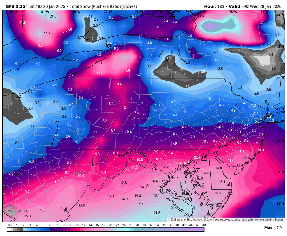
If you like global models at this range, cmc much snowier. Near 20” in northern Lehigh County. Was 10-12” at 12z. Every 00z model and weather app is screen shotted for comparison [emoji23] I leave you with mine. Up at 3am for all day plowing in Bethlehem. . -
January 25-26 Winter Storm Potential
anthonyweather replied to Ralph Wiggum's topic in Philadelphia Region
6-8” Lehigh -
January 25-26 Winter Storm Potential
anthonyweather replied to Ralph Wiggum's topic in Philadelphia Region
Yikes . -
January 25-26 Winter Storm Potential
anthonyweather replied to Ralph Wiggum's topic in Philadelphia Region
Here’s the real problem on the RRFS . -
January 25-26 Winter Storm Potential
anthonyweather replied to Ralph Wiggum's topic in Philadelphia Region
Yep they have been unbeatable. Hate to see the NAM go . -
January 25-26 Winter Storm Potential
anthonyweather replied to Ralph Wiggum's topic in Philadelphia Region
You think there is some evidence to this? Looks like a window of about 4pm-10pm Sunday those 2 models are spinning up gusts close to 40 in the LV . -
January 25-26 Winter Storm Potential
anthonyweather replied to Ralph Wiggum's topic in Philadelphia Region
Gonna have hard pack all week.... this will be one of the worst cleanups in my memory. salt is virtually ineffective under 23F -
January 25-26 Winter Storm Potential
anthonyweather replied to Ralph Wiggum's topic in Philadelphia Region
NAM & GFS still showing blizzard warning criteria Sunday late afternoon and evening for the Lehigh Valley. "Criteria for Winter Storm Watches and Warnings Blizzard: 1. Sustained wind or frequent gusts to 35 mph or greater; and 2. Considerable falling and/or blowing snow reducing visibility frequently to less than 1/4 mile for 3 or more hours." -
January 25-26 Winter Storm Potential
anthonyweather replied to Ralph Wiggum's topic in Philadelphia Region
Really what's the difference? is that extra inch or two going to change his lifestyle? -
January 25-26 Winter Storm Potential
anthonyweather replied to Ralph Wiggum's topic in Philadelphia Region
Wind gusts 1AM Monday on gfs close to 40mph in eastern pa . Evidence this could persist 6+ hours which again, puts us in definition of blizzard warning criteria. Blizzard Warning A Blizzard Warning means that the following conditions are occurring or expected within the next 12 to 18 hours. 1) Snow and/or blowing snow reducing visibility to 1/4 mile or less for 3 hours or longer AND 2) Sustained winds of 35 mph or greater or frequent gusts to 35 mph or greater. There is no temperature requirement that must be met to achieve blizzard conditions -
January 25-26 Winter Storm Potential
anthonyweather replied to Ralph Wiggum's topic in Philadelphia Region
its defined as sustained of 35 mph or more OR frequent gusts over 35 -
January 25-26 Winter Storm Potential
anthonyweather replied to Ralph Wiggum's topic in Philadelphia Region
nam euro and gfs have quite a few hours of 35mph gusts Sunday evening which meets criteria , of course its only Thursday but something to keep an eye on -
January 25-26 Winter Storm Potential
anthonyweather replied to Ralph Wiggum's topic in Philadelphia Region
I'm starting to become curious if this thing accounts for mixing or if its heavily based on the GFS -
January 25-26 Winter Storm Potential
anthonyweather replied to Ralph Wiggum's topic in Philadelphia Region
Sunday evening/night holds blizzard warning criteria. Something to keep an eye on. -
January 25-26 Winter Storm Potential
anthonyweather replied to Ralph Wiggum's topic in Philadelphia Region
mixing line really creeping on euro too -
January 25-26 Winter Storm Potential
anthonyweather replied to Ralph Wiggum's topic in Philadelphia Region
ill take the next 20-30" storm GFS advertises next weekend too! -
January 25-26 Winter Storm Potential
anthonyweather replied to Ralph Wiggum's topic in Philadelphia Region
I-95s might have to start worrying. Lot of rain on ICON -
January 25-26 Winter Storm Potential
anthonyweather replied to Ralph Wiggum's topic in Philadelphia Region
Anyone see the UK? Widespread 18-28" -
January 25-26 Winter Storm Potential
anthonyweather replied to Ralph Wiggum's topic in Philadelphia Region
Just got off the phone with a met at Mt holly. NBM isn't based off 10:1, but it's not kuchera either. It averages amounts out to account for average ratio based on temp profile. -
January 25-26 Winter Storm Potential
anthonyweather replied to Ralph Wiggum's topic in Philadelphia Region
Ill beat Facebook map man to it