CoastalWx
-
Posts
176,166 -
Joined
-
Last visited
Content Type
Profiles
Blogs
Forums
American Weather
Media Demo
Store
Gallery
Everything posted by CoastalWx
-
Op runs are gonna be all over. GEFs looked fine.
-
Gfs looks fine to me.
-
Ginxy drifts
-
We had -NAO look but never had confluence sustain itself like what’s modeled.
-
I don’t recall seeing that look in December. We had the blocking, but the PV got pushed west and we never had true confluence to our northeast.
-
He whined about Rihanna for two days.
-
I mean first chance of anything might be day 7-8. Not exactly clown range.
-
That's not true at all. Not this "close" in and not from multi suites of guidance.
-
I know everyone is snake bitten...and trust me I am with you. But for the first time all winter...we've had 3+ days of models showing something later next week. While of course this is still in the extended time frame when things could go wrong...that does mean something IMO. When is the last time we've had consistency....other than mild conditions being modeled?
-
I've seen that floating around too. I don't mean that in a bad way.
-
Doesn't get any more unstable than this. Go up moist adiabatically from 900mb and you can just envision the MUCAPE. TTs 61 lol.
-
That was a bad bust. Guidance was too focused on the WAA delivering the precip and seemed to underestimate the explosive nature of the deepening mid level lows. That was a sub 500 Hpa low going under SNE. Unheard of really. One would wonder if the anomalous nature of that just did not play well with model guidance.
-
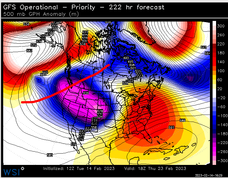
Charts!! This was sent to me from a met friend. I like this view. Two things I noted. Go back to a week ago. 1) PNA trending more negative. (Shocker). 2) The NAO area with more ridging. https://charts.ecmwf.int/products/mofc_multi_eps_family_hovmoller?area=North Hemisphere&base_time=202302130000¶meter=geopotential 500 hPa
-
I don't think it's threading the needle. In fact, it squashes one event next week. There would be wiggle room. I almost want to see that one event squashed in lieu of something much bigger.
-
Canadian would work.
-
Take the under a bit on BHO. I think they were "excited."
-
Yep, love to see that.
-
LOL, trough extending into the EPAC. Where have we seen this before. Better hope that blocking holds. These ridge fold overs have been a trademark this winter.
-
I've seen March 2018 as an analog too. I get it from a synoptic standpoint. Just wondering if there are similar ones with less prolific outcomes.
-
GFS op is a good example of why you'll need a sizeable block. We squash a small system to our south later next week, but a beast of a low out west wants to run right into this thing shortly after.
-
Well 1956 is prolific, so something perhaps more tame. Anyways, I think once again...the Pacific will help determine our fate. I feel like the NAO will flip negative, but if it's more of a lousy PAC (+EPO) then December comes back to haunt us I think.
-
What would be a better analog snowfall wise?
-
-
Sunday down here. Saturday...no lol.
-
Ryan H too. Unfortunately there was a min near the river that year.