CoastalWx
-
Posts
175,992 -
Joined
-
Last visited
Content Type
Profiles
Blogs
Forums
American Weather
Media Demo
Store
Gallery
Everything posted by CoastalWx
-
Active mid December with multiple event potential
CoastalWx replied to Typhoon Tip's topic in New England
CJ (well the CF) is sort of moving. Really need that to remain in place for hours. The mid level goodies people will jack. I'm just happy to get a good storm. Haha. -
Active mid December with multiple event potential
CoastalWx replied to Typhoon Tip's topic in New England
I think it looks great up there. -
Active mid December with multiple event potential
CoastalWx replied to Typhoon Tip's topic in New England
I like that Ray is pulling an "it's a wonderful life" and coming off the bridge. -
Active mid December with multiple event potential
CoastalWx replied to Typhoon Tip's topic in New England
Euro slams the WCB. Finally. -
Active mid December with multiple event potential
CoastalWx replied to Typhoon Tip's topic in New England
Just FYI this is still experimental. But some FB hero mets are pimping it out I guess. -
Active mid December with multiple event potential
CoastalWx replied to Typhoon Tip's topic in New England
Algorithm is whack. -
Active mid December with multiple event potential
CoastalWx replied to Typhoon Tip's topic in New England
That map looks strange from the Ukie. -
Active mid December with multiple event potential
CoastalWx replied to Typhoon Tip's topic in New England
weather.cod has regional sectors. -
Active mid December with multiple event potential
CoastalWx replied to Typhoon Tip's topic in New England
I think you are in a good spot. -
Active mid December with multiple event potential
CoastalWx replied to Typhoon Tip's topic in New England
Queens need to remember mid level tracks will raise those amounts near NH border to CON or so.
-
Active mid December with multiple event potential
CoastalWx replied to Typhoon Tip's topic in New England
I don't see subby stuff on the globals. Wonder if that is a hi res issue. -
Active mid December with multiple event potential
CoastalWx replied to Typhoon Tip's topic in New England
12z GFS looks real good in all areas. -
Active mid December with multiple event potential
CoastalWx replied to Typhoon Tip's topic in New England
Ever watch Yellowstone? They just get shot. -
Active mid December with multiple event potential
CoastalWx replied to Typhoon Tip's topic in New England
To answer Jay’s question, I think 9-13 will do it here. -
Low was 17 here. Coldest of the season.
-
Active mid December with multiple event potential
CoastalWx replied to Typhoon Tip's topic in New England
People are way too picky lol. Enjoy the storm. -
Active mid December with multiple event potential
CoastalWx replied to Typhoon Tip's topic in New England
Man if that WCB is just a little more in tact, the front end thump will be huge all over. Sort of what 3k NAM does. -
Active mid December with multiple event potential
CoastalWx replied to Typhoon Tip's topic in New England
That will only last a couple of hours. The uber stuff. Better near ALB. -
Active mid December with multiple event potential
CoastalWx replied to Typhoon Tip's topic in New England
Nah it parks out there for awhile. It may move SE sooner like they usually do. But it will only be in a narrow area. There isn't enough of a convergence angle to really drive CF enhancement much west of the boundary. -
Active mid December with multiple event potential
CoastalWx replied to Typhoon Tip's topic in New England
Yeah ratios may be decent here at first, but then it turns to man snow for awhile. Fine by me, would like some meat in the pack and snow on the trees. I don't have a ratios fetish....you really can't here when you blow over 40kts in every storm..lol. -
Active mid December with multiple event potential
CoastalWx replied to Typhoon Tip's topic in New England
Wiz gone wild. -
Active mid December with multiple event potential
CoastalWx replied to Typhoon Tip's topic in New England
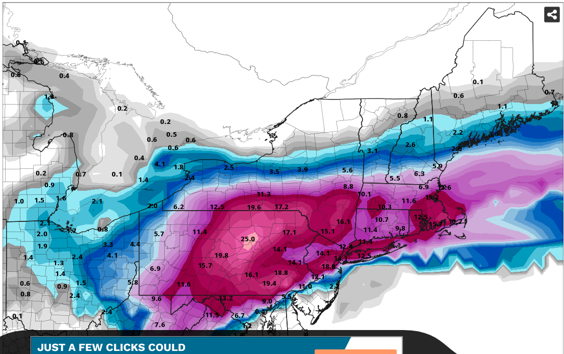
I think that area from near 128 (Wakefield to Newton?) could be the local jack. Some signs of weenie CF enhancement for a few hours tomorrow morning. -
Active mid December with multiple event potential
CoastalWx replied to Typhoon Tip's topic in New England
I envision a 3-4hr thump and then it is varying intensity. The upper end ranges will probably be only in a narrow area. -
"Chapstick?"
-
Active mid December with multiple event potential
CoastalWx replied to Typhoon Tip's topic in New England
I miss the days of not knowing about subby holes, jacks etc. Made tracking more fun. LOL.