

CoastalWx
-
Posts
175,995 -
Joined
-
Last visited
Content Type
Profiles
Blogs
Forums
American Weather
Media Demo
Store
Gallery
Everything posted by CoastalWx
-
That is pretty impressive. Not sure what the CDAS stuff is doing.
-
-
It's a dramatic change from a month ago.
-
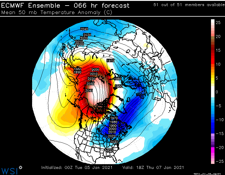
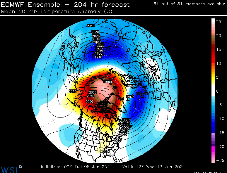
It's more like a displacement with a massive warm node from 50mb-10mb. But it definitely split the vortex and/or displaced it so far.
-
Yeah definitely "Christina!!" LOL.
-
More like day 8 I guess.
-
Nice storm. Into SE MA, but who cares this far out.
-
Euro sure isn't dry next 7 days.
-
As I said, if 2011 happens I will build a Ginxy statue. It just may be made of snow.
-
Easton did well. There was a massive gradient from about Duxbury on west-southwest through Taunton into RI.
-
Yeah as good as it has looked IMO. But over the last week...I think many of us have said it looks to improve second half of the month. I don't think that has changed.
-
I'm saving that.
-
Right. As I said earlier....I'm sure the south may get some winter wx. Not every storm can aim for us...but I don't see an overall suppression look IMO.
-
That's not a 09-10 -NAO. That is a Greenland ridge verbatim.
-
I guess you don't read anything I post. Glad that kid finally agrees with me on the Pacific.
-
It will gradually cool off. Certainly no well AN temps.
-
That's why sometimes it may look like I'm "Scooter Smash." Anyways, we shall see.
-
Significant upper middle Atlantic S/CNE mix/snow potential Jan 3+
CoastalWx replied to Typhoon Tip's topic in New England
Yeah about the same here. 0.4". Light snow now. -
I'm always happy. Just don't like whining. Hate when my kids do it, hate when the weenies do it.
-
I mean to actually look at something and not worry about cutters or prolonged warmth is nice. Sure cutters can happen in a well timed s/w...but I mean a cutter-like pattern.
-
Ha, I looked at guidance and was like sweet....even the op runs. They showed quite a bit of storms. This weekend is gone, but the 11-12 or whatever is in play on the ensembles.
-
I wouldn't worry much about suppression IMO. The fact that ridging develops near the coast of western NAMR usually isn't something to whiff, especially with a tad of ridging off the SE coast like the EPS has. Sure some storms may not always hit and whiff....but I don't see this as a "whiff" pattern.

-
Boy I wish models showed 4' of snow over me because we know models never change and lock onto solutions for 2 weeks.


