CoastalWx
-
Posts
176,066 -
Joined
-
Last visited
Content Type
Profiles
Blogs
Forums
American Weather
Media Demo
Store
Gallery
Everything posted by CoastalWx
-
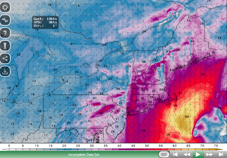
Yeah it is wind gusts. Sorry, that's the 3K NAM winds. I didn't mean to leave that out when I snipped it. What a beast.
-
-
Always a different world past exit 18.
-
I remember that. I was teetering.
-
Might be better at H5. It's early.
-
Monitoring a potential important TV to East Coastal storm: Jan 17
CoastalWx replied to Typhoon Tip's topic in New England
Look at all those "Ls" surrounding Ray. "Finish Him!" -
Keep an eye on Friday.
-
I'm glad you said that.
-
Which is why I won't burst into flames if Monday sucks here.
-
How many times did we say this? LOL. Weenies gonna ween.
-
We're onto next Friday.
-
Monitoring a potential important TV to East Coastal storm: Jan 17
CoastalWx replied to Typhoon Tip's topic in New England
I'll clarify, especially near the borderline areas. -
Monitoring a potential important TV to East Coastal storm: Jan 17
CoastalWx replied to Typhoon Tip's topic in New England
Take under on the snowmaps. -
Monitoring a potential important TV to East Coastal storm: Jan 17
CoastalWx replied to Typhoon Tip's topic in New England
Yuck on this run. -
WTF is that on the Euro? Cat 3?
-
That's a fairly sizeable shift.
-
Monitoring a potential important TV to East Coastal storm: Jan 17
CoastalWx replied to Typhoon Tip's topic in New England
Ginxy clearly you can see a more amped potential with the mean ticking west along with members clustering on west side and reduction of stuff near and east of center. -
Monitoring a potential important TV to East Coastal storm: Jan 17
CoastalWx replied to Typhoon Tip's topic in New England
GEFS? No idea. -
Monitoring a potential important TV to East Coastal storm: Jan 17
CoastalWx replied to Typhoon Tip's topic in New England
Am I assuming the bottom is the oldest run and top newest? -
Big decrease in the vid on the MWRA poop data. Maybe we peaked.
-
Monitoring a potential important TV to East Coastal storm: Jan 17
CoastalWx replied to Typhoon Tip's topic in New England
I almost treat it as more of a change in trend WRT time. Not necessarily what they have 6 days out or whatever. See what the trend is with the ensembles. It also helps seeing the members. When a large cluster looks like the op in a setup like this, lean back. -
Monitoring a potential important TV to East Coastal storm: Jan 17
CoastalWx replied to Typhoon Tip's topic in New England
They can fail in potent setups like this. I've found that to be true more often than not. -
When is the last time something like that even happened? Perhaps not to that extent..but a big snow there and barely an advisory here? March 2015 perhaps and maybe the Jan 2016 storm come close.
-
Monitoring a potential important TV to East Coastal storm: Jan 17
CoastalWx replied to Typhoon Tip's topic in New England
You'd have a decent pack if it didn't warm up. It wasn't an I-95 orgy either. That was a luck band from Boston +/- 10 miles either side to CT.