CoastalWx
-
Posts
176,078 -
Joined
-
Last visited
Content Type
Profiles
Blogs
Forums
American Weather
Media Demo
Store
Gallery
Everything posted by CoastalWx
-
Winter storm for the 25th of February is imminent.
CoastalWx replied to Typhoon Tip's topic in New England
I think you play some twister too. -
Winter storm for the 25th of February is imminent.
CoastalWx replied to Typhoon Tip's topic in New England
Yeah. One thing I did like seeing is that secondary start to take over. That will limit the sleet extent. It’s always tough to tell on euro without good soundings but I don’t think 6z euro got much sleet past I-90. -
Winter storm for the 25th of February is imminent.
CoastalWx replied to Typhoon Tip's topic in New England
It will probably correct itself if indeed the other guidance keeps the vort tracking where it is. -
Winter storm for the 25th of February is imminent.
CoastalWx replied to Typhoon Tip's topic in New England
Just dumbfounded. -
Winter storm for the 25th of February is imminent.
CoastalWx replied to Typhoon Tip's topic in New England
Euro is pretty snowy like region into SNH. Congrats ray. -
Winter storm for the 25th of February is imminent.
CoastalWx replied to Typhoon Tip's topic in New England
Gfs still seems decent. I still expect some ticks north. -
We FZFG.
-
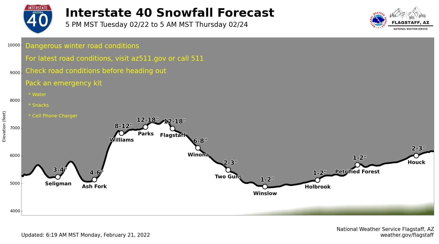
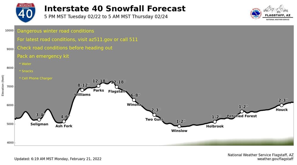
This is cool. I like this style of forecast.
-
Winter storm for the 25th of February is imminent.
CoastalWx replied to Typhoon Tip's topic in New England
Well maybe the 20th? -
Winter storm for the 25th of February is imminent.
CoastalWx replied to Typhoon Tip's topic in New England
We tuck? -
Winter storm for the 25th of February is imminent.
CoastalWx replied to Typhoon Tip's topic in New England
Wonder why Kevin specifically mentions Boston points south. -
Yeah, but the mean trough is so positively tilted, I don't think it means total cutter risk. Could be one of those deals that is like overrunning-->cutter-->mini Miller B...etc. It might not always be pretty....but given the time of year, I do want a nice supply of cold to my north.
-
Kind of an overrunning look. That’s a lot of cold in Canada into central US.
-
Yeah and both are pricey lol. My wife’s parents live in Hanover and my folks live in Marshfield. Hanover is a nice town. Right on rt3 and can get to the PYM/cape or Boston easily. Rt53 has a lot of stores/restaurants etc. But for now I’m cool here.
-
Winter storm for the 25th of February is imminent.
CoastalWx replied to Typhoon Tip's topic in New England
EPS looks pretty good too. -
Maybe Hanover area. NW of PYM.
-
Winter storm for the 25th of February is imminent.
CoastalWx replied to Typhoon Tip's topic in New England
Even if it started and ended at ZR, probably not enough for the damage you want. -
Man all those tweets earlier this month about last days of 20s...blah blah blah. LOL. We know models can be wrong, but too many people tulip trancing to seasonal models.
-
Probably a bit more south. We were looking hard last year and made some offers, but the market was just too stupid...it still is IMO. At the same time, we like this neighborhood, and the elementary school is good with a brand new junior high built, so we aren't in a rush to move.
-
Wolverines!!
-
Hope all is well man. Lets get a big one before you go. Where will you relocate to?
-
Come on down to Napeville.
-
Winter storm for the 25th of February is imminent.
CoastalWx replied to Typhoon Tip's topic in New England
Oh I was thinking more the sleet storm. -
Winter storm for the 25th of February is imminent.
CoastalWx replied to Typhoon Tip's topic in New England
Yeah true...I'm thinking more in the sense of the good airmass prior to it and the typical transition of snow-->sleet or snow-->sleet-->rain depending on where you are. -
Winter storm for the 25th of February is imminent.
CoastalWx replied to Typhoon Tip's topic in New England
Ukie is quite the thump. If you are risking a warmer solution, a nice thump can help offset that.