

mob1
-
Posts
2,172 -
Joined
-
Last visited
Content Type
Profiles
Blogs
Forums
American Weather
Media Demo
Store
Gallery
Posts posted by mob1
-
-
4 minutes ago, Chinook said:
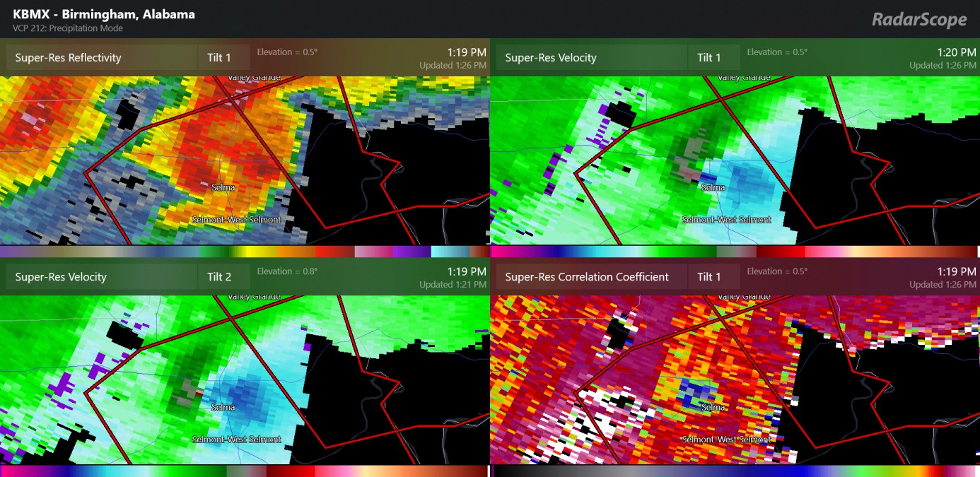
update: possible large tornadoes have occurred today in Alabama, Jan 12th, with this, minutes ago in the city of Selma Alabama. Up to now, there have been 13 preliminary tornado reports in Alabama.
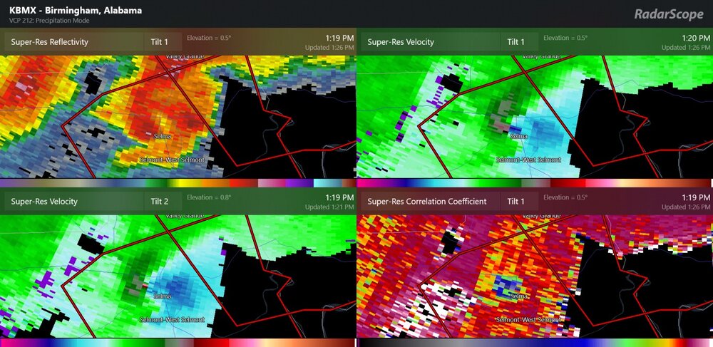
Debris lofted over 15K on that Selma tornado, looks like it definitely did some damage as it moved through a fairly populated area.
-
1 minute ago, CryHavoc said:
Couplet is absolutely raging.
This cell has been going for quite a while, and has looked impressive at times - though this is the first time it's confirmed.
-
Things are starting to get fairly active, though storm mode has been very messy so far.
-
Rotation is really tightening up on the Cell east of Gary City
-
-
Looks to have weakened or occluded on the last scan. Looked really nasty before that.
-
PDS warning with the cell east of Clark. Very large TDS with that one.
-
 1
1
-
-
This cell looks very impressive, the couplet is tightening up considerably. It has some junk to its south though so we'll see how it evolves.
Edit; now has a small TDS

-
While it probably doesn't matter in regards to frequency of storms, there are definitely some climate factors that can be directly attributed to stronger storms. An easy one is heavy rainfall and flash flooding, though that's not what's being discussed here.
Either way, people have to use common sense and trust that the NWS/NHC has nothing but their best interests in mind and even if they're not perfect (weather isn't en exact science) you should probably still take their warnings seriously.
If you evacuated and your city/town was mostly or completely spared, just thank the lucky stars and move on. Distrust for government agencies is at an all-time high, and while some of it may be deserved, you don't get to complain if you're told to get out but don't.
-
2
-
-
Really makes me wonder how areas that were never in the eye went through
-
3
-
-
Englewood, then east and NE to Port Charlotte and North Port is where I expect the most wind damage from.
-
1 minute ago, Amped said:
So the backside was stronger with less videos from it?
This is in Punta Gorda, where it took a while for the western eye to come in. It was probably worse (and far longer-lasting) a bit NW of there.
-
1
-
-
1 minute ago, lakeeffectkid383 said:
Makes no sense. Latest winds are stronger than they’ve been in a while from the WSW which would funnel the water right up towards the gauge…
Jumped back up to over 6' after falling to about 4.5' a few minutes ago.
-
1 minute ago, schoeppeya said:
Makes no sense with strong onshore winds still
Winds picking up there as well after a brief lull, the same gauge now shows gusts over 70 mph. Not sure why the surge drained out so suddenly.
-
2 minutes ago, sojitodd said:
Looks like it peaked at 7.66 and has dropped slightly now.
Now dropping like a rock
-
1
-
-
North Port has been getting walloped by the northern eyewall for hours now, looks like a fairly sizeable city too (relatively to the intercostal ones like Englewood).
-
2 minutes ago, dan11295 said:
From Englewood-Fort Port-Port Charlotte have been getting hammered with the intense N eyewall for a while now.
And for areas just S and SW who have been in a lull, the backside winds still look fairly potent.

-
1
-
-
Wow, that last drop shows how strong the western part still is.

-
 2
2
-
-
Just wow
-
3
-
 1
1
-
-
Eye still looks great on radar, and still plenty of lightning too.

-
1
-
-
2 minutes ago, Rockem_sockem_connection said:
Some people don't have to pretend since they actually live in a place that gets hurricanes and feel bad for these people.....
Good for them. I obviously don't wish anyone harm, but as a weather enthusiast I want to see the most beautiful storm possible.
-
IR presentation looks a hair better now than an hour ago, the eye is still filled in but looks a bit more symmetrical, though it might not fully clear out on visible.

-
4
-
-
We can pretend to be grateful about the eastern eyewall being incomplete on the main thread, but my inner weenie wants that eyewall fully encircled by stronger returns so badly.
-
3 minutes ago, CoastalWx said:
Possible that strongest winds north of worst surge which I suppose is a slightly better outcome?
Would likely help a bit. SE and E side continue to show structural issues on radar. Hopefully it stays that way.


Texas/Oklahoma Discussion & Obs Thread 2022
in Central/Western States
Posted
Don't know where to post this, but there's a tornado emergency east of Houston. Massive debris ball with it as it passed on the eastern side of Deer Park.