mob1
-
Posts
2,369 -
Joined
-
Last visited
Content Type
Profiles
Blogs
Forums
American Weather
Media Demo
Store
Gallery
Posts posted by mob1
-
-
Some models have it affecting either the far eastern US (Nantucket or eastern Maine) or the Canadian maritimes.
Euro in general has a lot of traffic in the entire basin.
-
27 minutes ago, NorthHillsWx said:
Still no FFW with the event yet
First one just went up north of LA.
-
8 minutes ago, NJwx85 said:
The core is obviously gone and the radar doesn’t look overly impressive over Baja. I’m wondering if the forecast is overdone outside of areas with local enhancements from terrain/elevation.
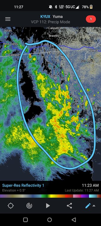
This area has seen incredible training of cells, as Hilary moves northward it should give parts of SW CA a lot of rain.
A big chunk of death valley has seen moderate rain all morning, and it doesn't take all that much to get flooding there.
I wouldn't spike the ball just yet.
-
 1
1
-
-
-
18Z looks very interesting at 90 hours with a tropical storm approaching the Leeward islands.
-
 1
1
-
-
0.53" here.
From the NYC area airports, it looks like only LGA recorded more than an inch.
-
Nice little soaker here with this last batch getting me up to 1.27" for the day. It's deceptively heavy, even though it doesn't look overly impressive on radar.
-
 1
1
-
-
1.11" for the day (and counting) between this morning's rain and the weakening line just now. Nothing exciting in terms of severe obviously, which has been the theme all summer here.
-
-
-
-
-
NAM (both regular and hi res) have another soaker tomorrow for the city (though aerial coverage isn't as extensive as today).
-
Just crossed an inch with some pretty heavy rain about to move in. Hopefully the line from New Brunswick to Trenton beefs up again, it really shrunk in aerial coverage.
-
 1
1
-
-
For the city proper, it looks like Brooklyn will be the big winner for now. Cells keep developing to their SW and training over the same area.
-
0.73" so far and looks like some small training cells setting up for the eastern part of SI and western part of Brooklyn.
-
Quick .33" here, had some rain overnight as well. Still relatively dry here overall, less than 4 inches since June 1st.
-
Pretty strong signature between Oak Park and the city proper.
-
1 minute ago, A-L-E-K said:
What do I got to do to get a tor over the apartment
Cancel your renters insurance
-
 2
2
-
 6
6
-
-
-
Confirmed tornado near O'Hare
-
Just now, MNstorms said:
Looks like the TORD radar may have failed. Hasn't updated for 12 minutes.
That explains a lot.
-
-
Just now, SchaumburgStormer said:
Confirmed tornado in Kane county as well
On and off TDS with that one. For the Chicago cell, it's in a really terrible radar spot and I wonder if that PDS warning is justified.


.thumb.png.452fe92e60660cf219a4de5f8effa1ad.png)


Hurricane Hilary
in Tropical Headquarters
Posted
Lots of training cells over Death Valley and areas west of Las Vegas, flooding could be pretty bad there.