

Blizzard-on-GFS
-
Posts
697 -
Joined
-
Last visited
Content Type
Profiles
Blogs
Forums
American Weather
Media Demo
Store
Gallery
Posts posted by Blizzard-on-GFS
-
-
Just now, JMcCaughey42 said:
Haha if only
To be fair. I think somewhere just NW of I-95 between philly to boston might take a crack at 12" in an isolated area or two.
-
12 minutes ago, JMcCaughey42 said:
Latest RAP looks awesome fwiw

I'll take my 16" and run

-
 1
1
-
-
Just now, dizzy9479 said:
Looking at COD radar, it looks like the rain line is encroaching upon Wilmington and the PA/MD line -- a little worried about that.
It will crash SE as the coastal low picks up steam and heads NE.
-
1
-
-
1 minute ago, kickingupastorm said:
Can you post the map?


-
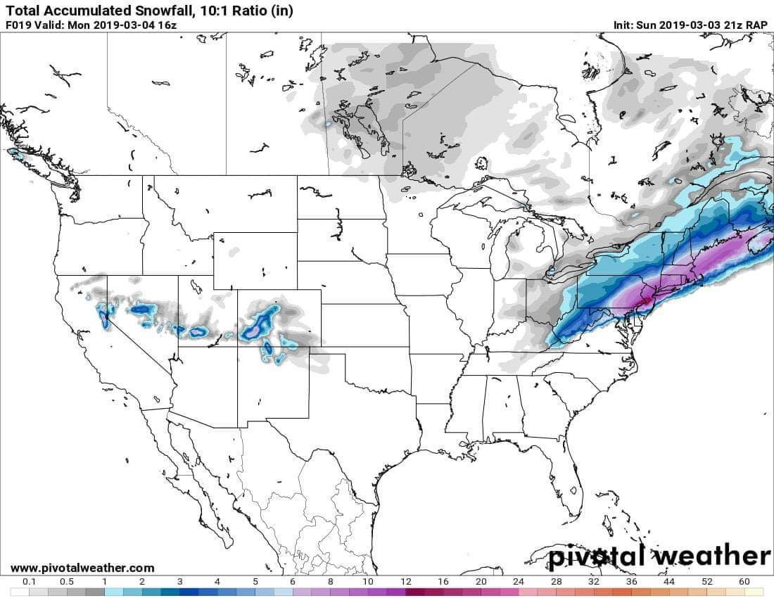
Just flipped to all snow in Bordentown, NJ. BTW: 18z RGEM and HRDPS slam us around I-95. Way colder than the american models. Let's hope they are right about the crazy rates tonight.
-
Ride or die with the canadian suite. American suite and the 18z NAM is ugly for I-95 and east. Storm feels over before it even began...
-
2 minutes ago, ChasingFlakes said:
Big difference between the ferrier rime corrected map and the 10:1 3k NAM 12z. Keep that in mind.


I'm not a big fan of the ferrier. I think it goes overboard in a lot of cases. I think that 3k map is pretty realistic, but I think the axis of heavier snow will be a bit northeast of that.
-
2 minutes ago, Ralph Wiggum said:
Hrrr is taking lsd apparently....has my area in Bucks under moderate snow (lighter here and there at times) from 7pm tonight thru 7am tomorrow. Not sleet. Yet snowfall map has .25" snow. Loving the surface maps...colder and earlier onset, but the snowmaps are a complete joke. There is no way many hours of mod snow falls and we only get .25"
Lol I was just looking at that and thinking the same thing. Either way I think the mesos are picking up on the CAD at this point and see something the global don’t. I think we start frozen longer than being forecasted.
-
28 minutes ago, ChasingFlakes said:
Virga in Phoenixville as of 9:15pm. Weather underground has me at 7" storm total including sleet and around a half inch of rain. We'll see if that plays out.
Edit: 9:30 still virga.
Also, does WU use proprietary models for forecasts or do they adhere to a specific model suite? Their website makes it seem proprietary with their comparisons to the NWS.
You have the option to use NWS forecasts, or their proprietary algorithm that blends model suites vs real time data observations from their vast network of weather stations. That is why they have by far the most accurate weather forecasts out of any mainstream outlet. I love me some WU.
-
Ralph those days are long gone and the few that where leading the charge have gone and left. I feel it would be great for both forums to drum up some more discussion.
This subforum was great back in the day but it is now really beyond dead. I frequent the NYC forum much more even though my location doesn't quite align with the discussion.
-
My first call map for Sunday night ⛄️
March 3-4, 2019 Snow/Rain Event
in Philadelphia Region
Posted
Huge bust in Bordentown, NJ. Flipped to sleet hours ago and never went back. Haven’t measured but looks like less than 3” here. Congrats to the NW crew that cashed in, happy for you guys!