

Blizzard-on-GFS
-
Posts
697 -
Joined
-
Last visited
Content Type
Profiles
Blogs
Forums
American Weather
Media Demo
Store
Gallery
Posts posted by Blizzard-on-GFS
-
-
4 minutes ago, The Iceman said:
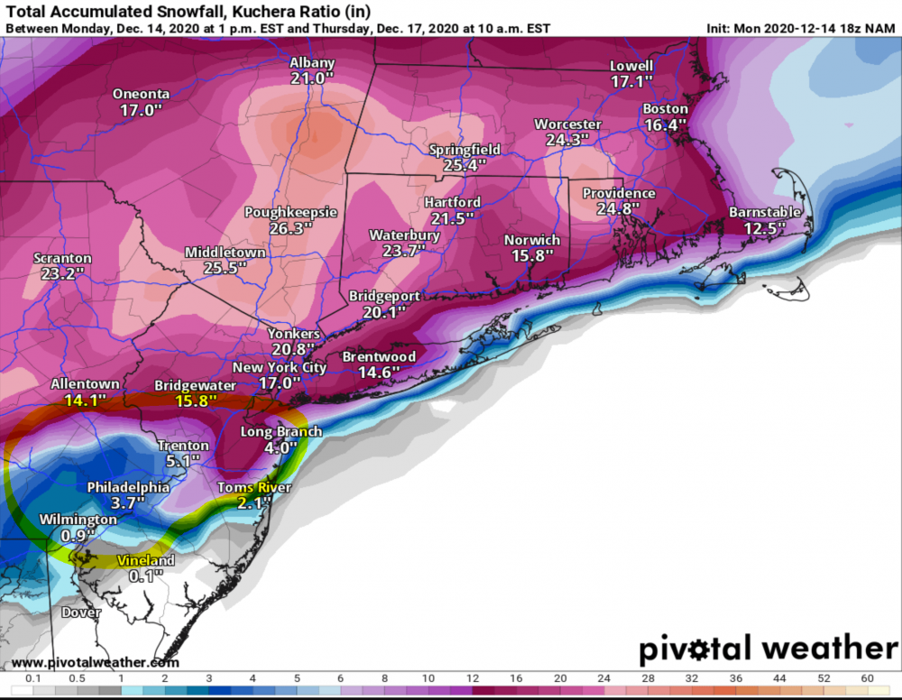
I agree to disagree. There is still a fair amount of spread and mt holly has done that in the past and been burned. Better to start conservative and increase as we get closer. Remember watches haven't even been hoisted yet, we are still a good 60 hours out from first snow. Things can change. Plus that map is from this morning when things were even more uncertain. I bet it increases in the afternoon update. Mt holly is one of the best, I trust them.
For north and west yes there is huge spread. For CNJ pretty much every model shows a foot plus. If people are expecting 4” and get over a foot that is a huge difference on impact that people need to prepare for.
-
8 minutes ago, The Iceman said:
This is dated, but i didn't see it posted here. Mt Holly first call. I wonder if we see them tick up a bit in the next update. Thought the map was perfect though, well done Mt Holly crew!

I have to disagree. I think this map is comically low and is supported by no model. It's straight up misleading. Especially for I-95. Solid model consensus on 10-16".
-
 4
4
-
-
After years of having the rug pulled out from with under me in CNJ I think this storm is finally going to deliver! All models are now showing a CCB rotting over I-95. This storm has that classic look that you want for storms that produce in the I-95 corridor. I really think this pans out as 10"+ for most of this subform. I can break my like 4-5 year drought of no double digit snowstorms.
-
 3
3
-
1
-
-
8 minutes ago, hazwoper said:
The ICON is awful. Period
The ICON should never be used in a professional forecast. I use it at most to confirm a trend from the rest of the model suite. As a stand alone solution it is completely useless...
-
I feel like the GFS chased the convection off of the NC coast on this run. You would think the low transfer would happen closer to the benchmark based off H5. Euro depiction makes more sense at the moment. A lot of time here for this to resolve itself.
-
1
-
-
Just now, The Iceman said:
Euro kind of shears the storm out over us... Not much precip at all but the cold is there

I'll take 3" of fluff all day! I hate mixing.
-
2
-
-
33 minutes ago, NEG NAO said:
0Z ICON is unbelievable

I was just viewing this run and thinking how much a joke the ICON is lol. It certainly should be used by anyone trying to make an accurate forecast. It's always in la la land in the mid range.
-
20 hours ago, Fields27 said:
Ended up with about 7" in Reading. That warm air push was insane. Once models started trending with that warm layer I got really concerned with the high totals being projected. Always seems that if models project a flip it normally happens sooner than later and kills totals around here. Still a nice storm, and a week before Christmas.
Also congrats to central PA and upstate NY, wow.
Sent from my SM-N975U using Tapatalk
Anytime you have a track with a low riding up the Delaware Bay into Jersey thats no bueno. Especially if MESO models show the warm layer like the NAM did. Sometimes you have to use Meteorology and not model-ology . Synoptically there's no way we were going to get an all snow outcome in our area with that track. I hope people learned their lesson using clown 10-1 maps and even Kuchera. It's snow depth maps or nothing. This forecast was more simple then people made it out to be IMHO.
-
1
-
-
sleet in Lambertville
-
32 minutes ago, donsutherland1 said:
As per mPING, there is some snow in such locations as Princeton and Freehold.
It has been snowing in Bordentown for about 30 minutes, we have a solid coating already.
-
1
-
-
Just now, jdj5211 said:
So we're about 36 hours from the storm and we generally have no idea what's going to happen? And by that I mean, who is getting shafted, where the heaviest precip falls, is there a dry slot, is there a jackpot zone? Is that fair to say.....
Yup this is a nowcast event for I-95. My call is 5-20". That should about cover it haha. For trenton I'm calling 8-14" but that could easily fall apart. The mixing line cutoff is going to be brutal.
-
Just now, friedmators said:
GFS is a CNJ JP.
Please just let us have this just one lol. It's been years since I saw more than 2" of snow haha
-
1
-
-
NAM looks to be coming in better with thermals for marginal areas, HP looks better.
-
1
-
-

This frame is a bomb. Dynamics save the day
-
1
-
-
GFS coming in NW. Getting real worried for the I95 crew now. This might end up being a North and West storm.
-
1
-
-
I'm worried about getting dry slotted and mixing heavily in CNJ as should I-95. I hope the MESOS are overamping this. Sometimes they under do the confluence so we'll see who wins out. Globals look way different at this point. Let's see if they hold serve with the 18z runs.
-
1
-
-
1 minute ago, David-LI said:
Because it doesn't have a foot in your backyard throw the run out?
No because it's an outlier. I don't live in in SE Pa but there's no way that Northern Bucks County PA gets 5" while northern Ocean County NJ gets over a foot. Also it extends the heavy precip way further north than any other model.
-
1
-
-
No chance this happens for the yellow shaded area, huge outlier. Toss it.
-
NAM is clueless lol. This run's solution is laughable. I wouldn't even look at the NAM till tomorrow afternoon. No way the cutoff is that sharp and southeastern PA gets shafted like that.
-
1
-
-
2 minutes ago, SI Mailman said:
subtract 2 to 3 inches in NW NJ from tomorrow's storm

This map has to be way over done for I95 east. They would see a lot of mixing with this track.
-
 1
1
-
-
Euro run is horrible. No one from I-95 east is getting more than slop with that track. Let’s hope the GFS holds serve. The Euro has been over amping some coastal storms in our area the last few years so we have hope.
-
1
-
-
Just now, SI Mailman said:

Yuck, horrible track for CNJ. I’m hoping the Euro is over amping this.
-
1 minute ago, MJO812 said:
Ugly ? Its beautiful
I'm from central NJ. (Southern Mercer County). There's gonna be a razer sharp cutoff around my parts. I think NYC and north is game set and match to get hammered regardless.
-
 1
1
-
-
Just now, SnoSki14 said:
It's either gonna rain or snow, I don't see much sleet with this.
I meant to say ZR and Sleet. I'm real nervous for my area just NE of philly. NYC should be fine due to the latitude. I think the farther north you are the better with this storm.

Jan. 31-Feb. 2 Miller B storm
in Philadelphia Region
Posted
Do you think the coast could see a blizzard warning? The watch says winds to 50mph. I imagine that might meet blizzard conditions. I haven’t been looking at the winds on the models myself but that’s something to keep an eye on