

Blizzard-on-GFS
-
Posts
697 -
Joined
-
Last visited
Content Type
Profiles
Blogs
Forums
American Weather
Media Demo
Store
Gallery
Posts posted by Blizzard-on-GFS
-
-
46 minutes ago, White Gorilla said:
It was gusty for sure here, but I didn't hear about much impact locally. Does anyone have any peak gust data at Atlantic City?
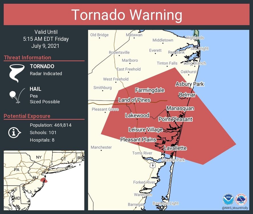
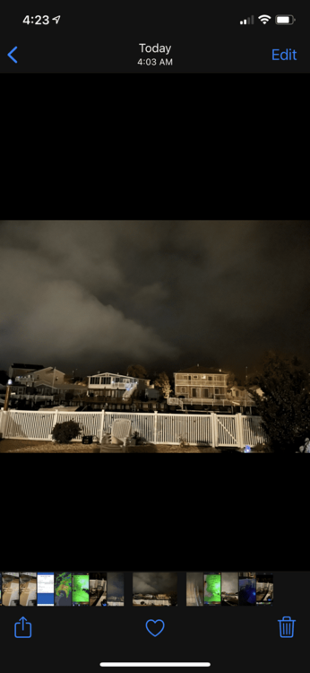
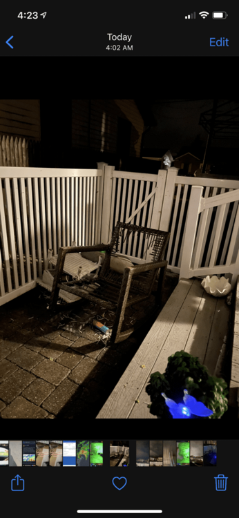
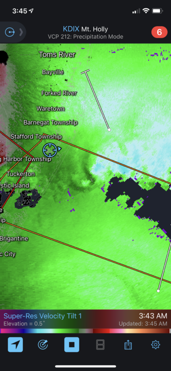
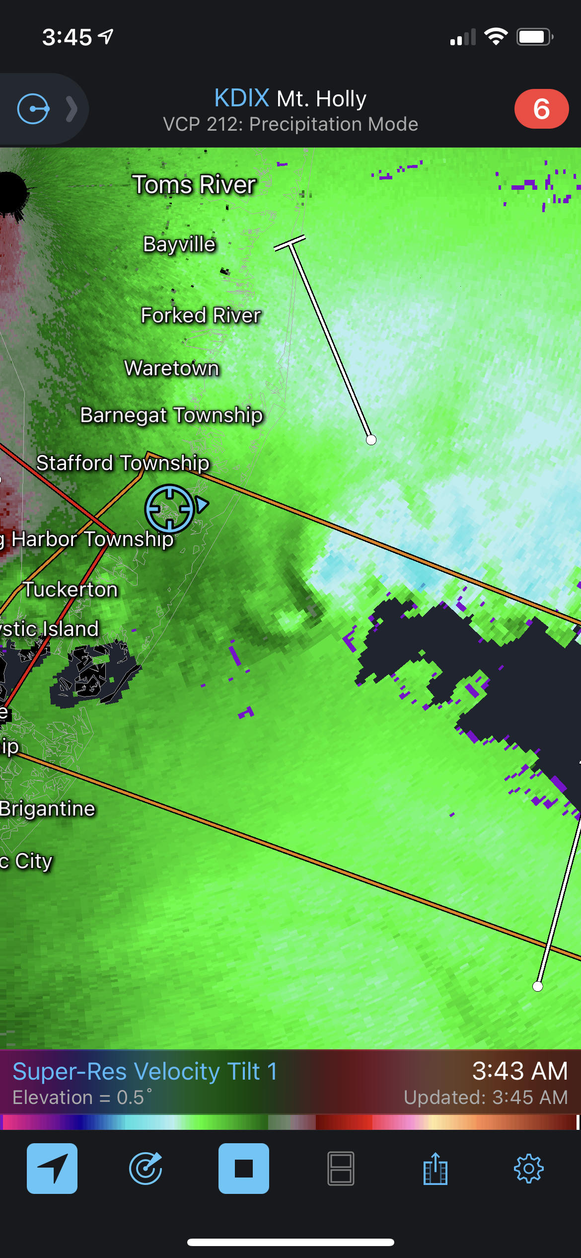
Yes I am in beach haven west and believe a weak tornado passed over my house. I watched day burst of windo launch my lawn furniture into my fence.
-
3 minutes ago, SRRTA22 said:
What looks like a large waterspout is about to move onshore near Mantoloking,NJ or just south of Point Pleasant
Thing is massive on radar. I’d be legit concerned in those areas. Who knows if it will hold together by landfall though.
-
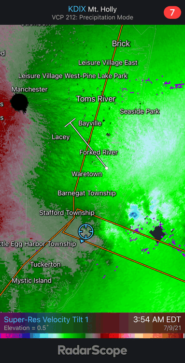
Is this a massive waterspout off of Brick? Velocity radar seems to indicate so…
-
3 minutes ago, Blizzard-on-GFS said:

-
 1
1
-
-
Just now, Blizzard-on-GFS said:
I believe a funnel cloud just passed over my yard in Beach Haven West. It was calm and the sudden woosh of air came in and launched my table and chairs off my porch and into the fence. I was watching this cell on radar and it appeared to have a couplet to my untrained eye. Could a Met chime and and see if they agree?
-
Appears to be lots of rotation in these cells east of Stafford Township. I expect to see the Tornado Warning to be issued further north again as it has been moving up the coast all night. There should have been a watch issued.
-
I'm surprised more people aren't talking about the TOR threat for NJ and NYC tomorrow night. I'm almost certain a TOR watch will be hoisted tomorrow night.
-
1
-
-
I like my location in Manahawkin NJ to do well here. Expecting 3-6" of fluff. I feel like wherever the banding sets up in these types of events tends to overperform. NWS in agreement. I'm just happy to have an all snow event for the first time all year.
-
1
-
-
1 minute ago, Birds~69 said:
You're in the more intense precip hopefully headed my way...
28F / mod snow

For the first time all day Bordentown is in a good band. Its an weird random band but its back building and I’m happy lol. Whatever it takes!
-
WSW just issued for an additional 3-6”. I’ll take it. That would put my total in the 8-12” range.
-
Wow radar just filled in nicely for the Philly to Trenton areas! Snowing pretty hard here now in Bordentown. I’ve got a little more hope we can pick up some more accumulation. HRR is spitting out an additional 3-6” which I would be more than happy with.
-
2
-
-
27 minutes ago, TheBigBlueBox said:
18z NAM seems to develop a second slp off the NJ coast. Keeps snow in the area through tomorrow afternoon.
Why is the NAM showing another foot for our area? I don’t trust the models anymore. Did it initialize wrong?
-
1
-
-
Wow this gonna be a top 3 bust all time for my location near Trenton. At least I’ve learned NEVER to trust a 10-1 snow map again. I looked at the snow depth maps last night and they had this writing on the wall but I didn’t see anyone on these forums posting the maps. If there’s a warm layer nearby it will find a way to muck things up. Also, Miller Bs rarely work out for I-95 and east. And lately, if your on the border of a dry slot, expand the dry slot because subsidence will make areas on the edge lose out every time.
-
2
-
-
Just now, HVSnowLover said:
Okay 5 inches is low but most areas are already a foot plus. What happened there was it too dry or too much mixing?
Literally we got pretty much zero snow from the coastal. This is a top 3 all time bust for my area. 0z runs last night showed a consensus 12-24” additional and we are gonna end up with 1-3” more at most. We might be done already. Feels bad man...
-
13 minutes ago, HVSnowLover said:
I get we all want epic storm but the totals already are nothing to sneeze at
Lol my 5” in Trenton?! What an epic bust this storm was.
-
24 minutes ago, famartin said:
Gotta say, been kinda amusing to see how badly the models have done with P-type in the Trenton area today... 12 hours of sleet, 4.4" total on the ground.
Yes man, I woke up late today and looked at the radar and immediately said wow holy crap this thing busted. I looked at the radar and got sick, you can tell that that banding is going to pivot north west of us. This will be year three without a good storm, it’s amazing how every time we have a set up at somehow collapses at the last moment...
-
1
-
-
2 minutes ago, Sn0waddict said:
Comparing 0z to 4z HRRR it seems to be moving the low east a bit. Also more impressive with snow totals. Has SW CT at 7 inches by 15z vs 5 inches. Low is stronger as well.
HRRR is completely and utterly lost on this one. Just look at the radar sim. It has no CCB and precipitation field to the west of the low. Not gonna happen, it's an extreme outlier. Even the other mesos whole disagree.
-
1
-
-
1 minute ago, RedSky said:

Interesting to see a more north to south cutoff on the jackpot zone emerging compared to the Northeasterly cutoff earlier. Makes sense with a Miller B to see this though.
-
Just now, RedSky said:
Strong storms hugging the coast almost always mix even in SEPA for a time
I didn’t expect this to be a hugger thorough. But yeah I’d like an all snow event for once, it will be close
-
Just now, RedSky said:
As expected yes most of it S&E of I95
It wasn’t expected, we were all snow on nearly all models till recently.
-
1
-
-
Just now, RedSky said:
Comprehensive area of 12-20"
Does I-95 mix?
-
1 minute ago, Ralph Wiggum said:
Strongly agree. NyC should be the bullseye when all is said and done down to Monmouth
How are you feeling about TTN? We've been shafted for years lol. Gfs and Euro jackpot us, while the mesos screw us in different ways. I'm probably a bit more nervous then I should bee..
-
The best part is it's still snowing past 84 hours lol


E PA/NJ/DE Summer 2021 OBS Thread
in Philadelphia Region
Posted
That’s such a nasty hail signature!