

Blizzard-on-GFS
-
Posts
710 -
Joined
-
Last visited
Content Type
Profiles
Blogs
Forums
American Weather
Media Demo
Store
Gallery
Posts posted by Blizzard-on-GFS
-
-
2 minutes ago, SACRUS said:
2/23 00z RAP
through 4PM Monday starting 8pm

Snow

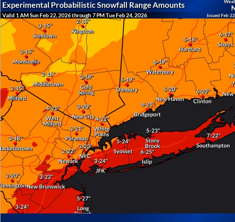
18.5" MAX over my house in Manahawkin, NJ. HRRR prints out another 20" here in south jersey. I only have 2" so far so I hope I cash in when these bands start pivoting.
-
WOOF. I'm in a good spot in Manahawkin,. I'm hoping this deathband pivots over me. Where ever it pivots on is going to get clocked.

-
 3
3
-
 2
2
-
-
"I'm playing both sides that way I always end up on top"Upton hedging with 3-23" lol
Mt. Holly has a crazier 1-25" for Philadelphia
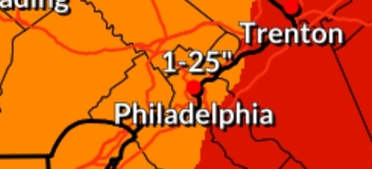

Sent from my SM-F966U1 using Tapatalk
-
 1
1
-
-
I'm riding out the storm at my parents house in Manahawkin New Jersey and I think we have a real chance at 30 in down there. Going to be a historic storm. I'm hoping this will be the best snow storm I've ever seen in my life as a 34 year old.
Sent from my SM-F966U1 using Tapatalk-
4
-
-
For me at the Jersey shore in Ocean county this might be the best model of run I've ever viewed ever for my town lol going to be 3 ft at least
Sent from my SM-F966U1 using Tapatalk -
I feel like that goes for really any of the major models. When one model is absolutely locked on to a solution with consistency you have to give it greater consideration.What did we all learn this week?
If the GFS is consistent run after run with minor waffling, you may want to listen. I doubted it
Sent from my SM-F966U1 using Tapatalk
-
A lot of you guys are going to owe the GFS a big apology after this storm wrecks us lol
Sent from my SM-F966U1 using Tapatalk -
Ripping snow in Bordentown, NJ
Sent from my SM-F966U1 using Tapatalk-
1
-
-
18 minutes ago, TriPol said:
You know what? It’s 2025. Let’s do this. Let’s push FEMA and the NWS to their breaking points and see how that goes.
lmao you beat me to it! I was about to post this hahah. Day After Tomorrow Vibes!
-
1
-
-
31 minutes ago, RU848789 said:
Wasn't sure where to post this HRRR comparison of 18Z and 0Z for tomorrow's little storm in SNJ/SEPA/DE, but in the vein of model mayhem, here's reason #993 to not trust the HRRR beyond 24 hours, lol...
Hey that's 2" for my house in CNJ, I TAKE. LOL. not gonna happen....
-
1
-
-
6 minutes ago, Newman said:
From my experience, on a more "normal" night of geomagnetic activity the "recharge" usually lasts 2-2.5 hours and then the spike back up is a quick 5-10 minute burst. Tonight isn't normal, we're talking very variable and chaotic conditions with the magnetic field strength. So from experience, I would say maybe around 10:30-11 there *could* be the next substorm. But it all changes in real time. I took this time lapse here earlier this week, which happened right during a substorm. Otherwise, the colors were mostly muted before and after this.
so cool! thanks for the heads up! Also, that Timelapse I stunning. I've always wanted to see the northern lights my whole life so hopefully tonight is the night!
-
4 minutes ago, Newman said:
Space Weather geek here: that huge burst of aurora was due to an auroral "substorm" that often occurs, we will likely see more through the night. You can track here at the GOES magnetometer site the strength of the parallel component of the Earth's magnetic field. I will explain why that's important below this...
https://www.swpc.noaa.gov/products/goes-magnetometer
Basically, what happens is the Earth's magnetosphere (more specifically it's magnetotail) gets stretched and then subsequently rubber bands back and releases the built up energy. When it rubber bands back, that produces the bursts of Aurora. They usually occur every 2-3 hours. On that website, you can time the substorms by looking at the large down spikes, that indicates the aurora is "charging up". Then when it spikes back up, that means it releases the energy in a beautiful aurora display. I would recommend changing the tab to 6 hours to get a close up view of what the magnetometer is measuring. All of this to say... You might have to wait another 2 hours or so for the bright views to come back! They come in waves and that's just the nature of these things. But it's cool, you can actually predict Aurora substorms and bright views.
Thanks for the awesome explanation! Based on this chart, can you give a rough prediction for the next time window we might see the lights again in our area? I missed the first round!
-
25 minutes ago, MGorse said:
Quick look at radar and the HRRR and it looks like the HRRR is not initializing the heavy band of snow in OH and western PA quite right.
After it totally botched the forecast on the last storm for Central New Jersey I’ve lost a lot of trust in it…
-
2 minutes ago, Blizzard-on-GFS said:
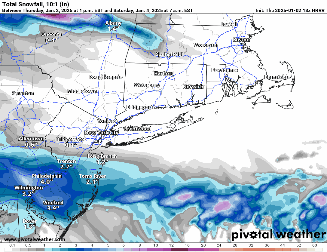
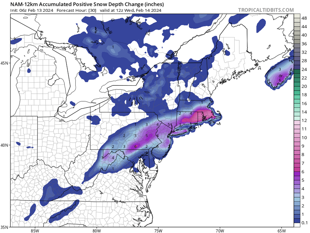
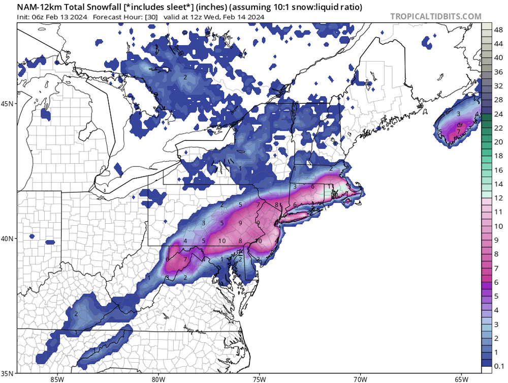
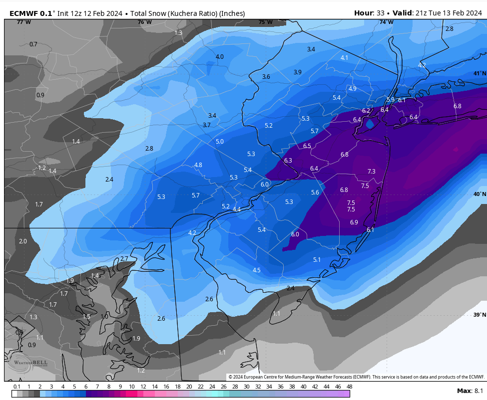
One thing I’ve learned from this is if temperatures are iffy, always use the snow depth snow maps, or look at soundings. Kuchera and 10-1 maps were completely off, even the 12z Kuchera this morning were printing out over 8 inches of snow for central New Jersey when most places in that area ended up with 1-2” at best. I remember last night the RGEM snow depth had about 1 to 3 inches for the area so it was pretty dang close and it was also pretty good for north and west areas where it had 6 to 8 inches modeled.
check out the massive differences below. 10” for CNJ on 10-1 vs 2” on snow depth. That should always be a tell tale sign.
-
One thing I’ve learned from this is if temperatures are iffy, always use the snow depth snow maps, or look at soundings. Kuchera and 10-1 maps were completely off, even the 12z Kuchera this morning were printing out over 8 inches of snow for central New Jersey when most places in that area ended up with 1-2” at best. I remember last night the RGEM snow depth had about 1 to 3 inches for the area so it was pretty dang close and it was also pretty good for north and west areas where it had 6 to 8 inches modeled.
-
1
-
-
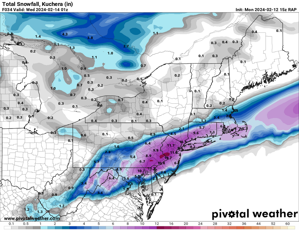
2 hours ago, LVblizzard said:
It is actually comical how far off yesterday’s 12z Euro was. Many of the areas in the 2-4” zone got a foot. And most of south Jersey away from Philly got shut out or close to it.

Epic Bust here in CNJ
 happy for the NW crew though. We got less than 2" and it has all been completely melted by mid-afternoon here in Bordentown, NJ. Kind of amazing how every model this morning had 4-8" for the area. Probably got around 1.5" if that....
-
 1
1
-
-
4 minutes ago, Birds~69 said:
6abc snow totals just now...
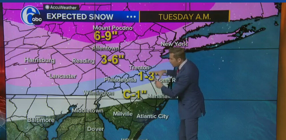
That 1-3” zone is going to bust terribly. Should be at least 4-8”
-
5
-
-
4 minutes ago, Heisy said:

.i-95 CRUSHJOB!
-
1
-
-
Starting to buy into the idea of an area-wide 5-10". With real heavy rates.
-
1
-
1
-
-
56 minutes ago, LVblizzard said:
15z RAP throws Philly weenies a bone…
BARK BARK!

-
3 minutes ago, HeadInTheClouds said:
It did come north at 18z FWIW.
Yes, slightly but the whole idea that this is going to be nothing but rain for odd 95 is definitely a doomer attitude. This is legitimate threat for I 95.
-
3
-
1
-
-
Well, well well, the “it’s going to trend north Crew” is in shambles right now lol.
-
1
-
-
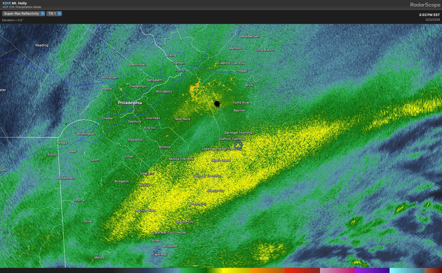
Ripping snow down in Manahawkin, radar looks great down here, we only saw a little over an inch with the earlier bands. This is our chance here for accumulations. SE Jersey coast looks to be in good shape. Waiting/hoping that this band pivots into an inverted trough as the low pulls away. Gonna be real interesting to see if that feature ends up setting up or not.
-
4
-
-
Waiting from them to drop a TOR warning on that bucks county cell. Rotation keeps strengthening


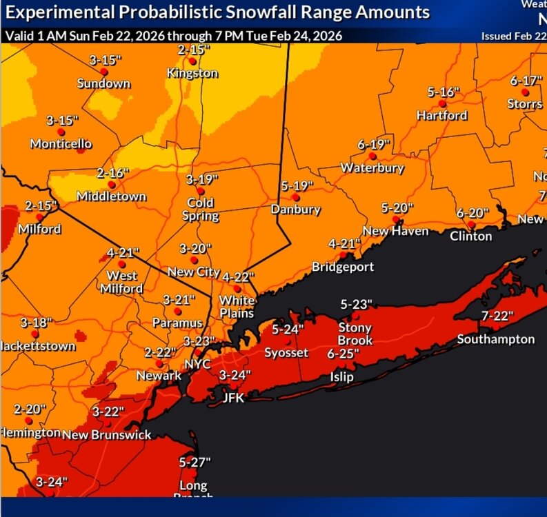
The Allsnow Blizzard of 2026
in New York City Metro
Posted
Yeah I WAS skeptical, but after looking over all the 0z model runs. Seems like tight consensus for another 18-22" for us. So when this thing gets cranking and pivoting, things might change quick. Dew point is currently at 31 so as soon as this next band rolls through I think we start cooking.