wxsniss
-
Posts
5,787 -
Joined
-
Last visited
Content Type
Profiles
Blogs
Forums
American Weather
Media Demo
Store
Gallery
Everything posted by wxsniss
-
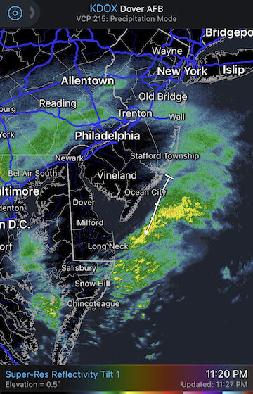
This activity off NJ not depicted on NAM until 2-3 hours later. Let's see how this progresses.
-
Wave spacing... has this been an issue before this season?
-
Yep, though I’d weigh mesos increasingly inside 24hrs. RGEM and GFS held. NAM RAP HRRR increasingly favor the eastern low. GFS also did shift in favor of eastern low, but end result was same as 18z. I’d do more upstream real-time analysis of that eastern low but I’m mobile.
-
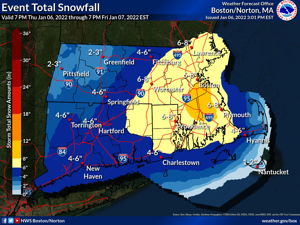
Supports Box forecast map… light / mid / dark green: 6-8 / 8-10 / 10-12
-
0z RGEM looks better…
-
Yeah just didn't like the trend, and thinking about rest of SNE... for us specifically, that runaway convection is precluding 10+
-
Yeah 3k NAM not as bad, prolonged event in east
-
Ugh not liking the trend on 0z NAM... eastern low takes over earlier. Still decent hit on eSNE but much less than possible.
-
01z (still comparing 18z 3kNAM to mesoanalysis): looks weaker by windfields and pressure
-
I know what you're referring to... now this is bothering me too lol... I remember dubbing it "mogwai" because multiple pieces of vorticity spawned all these disparate surface lows upon hitting the coast and as a result guidance was a mess... the night before was stressful in this forum... ultimately consolidated west and we had a blizzard I thought it was March 13 2018 blizzard but that was a fujiwara of 2 distinct lows
-
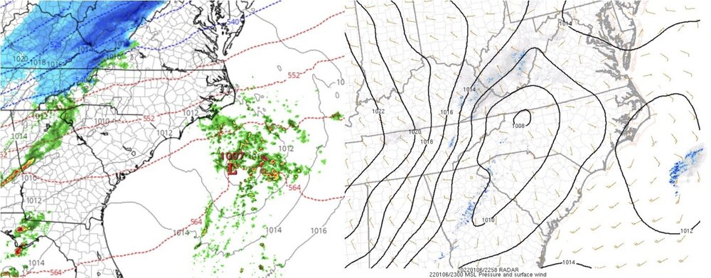
Hey Jerry sorry juggling other stuff at moment... Major reason 23z RAP stunk vs. 20z RAP is that eastern low refuses to decay and steals best dynamics east faster. Possible. I'm skeptical given the vortmax farther west over KY/WV and associated ground results. It's early, but using surface pressure and wind responses, was trying to see if guidance was too aggressive with that easternmost low.
-
Gotta step away for a few... will post more realtime when I can 23z (18z 3k NAM left, mesoanalysis right)
-
Definitely, awesome nowcast event with good rationale to anticipate upside...
-
Agree, that's been the fly in the guidance ointment for days... both from perspective of low placement and conveyor mechanics. See the 21z HRRR... it exemplifies that eastern low refusing to decay and shifting dynamics east faster. I think there's good reason to be skeptical of that with the intense vorticity over KY/WV and results on the ground, and the weaker-than-progged pressure/wind obs of our culprit off NC.
-
That 21z HRRR run looks strange... the eastern low, which materializes 4z-5z out of not much, refuses to fade the entire run, and so dynamics at our latitude shunt east faster than earlier runs. Stranger things happen, but I'd think the vorticity over KY/WV (apparently with results on the ground) will be the main driver of SLP development.
-
Definitely, I actually assumed it was a radar sparse area over the ocean... I'm looking at the pressure and wind field response of the ocean low, which are clearly lagging at least vs. 18z 3k NAM.
-
Yep, exemplified by 21z HRRR... between 4z and 5z Friday poof it develops a surface low far east that drives the show and refuses to give up the wheel... almost as if the strong vorticity rounding KY/WV were not there... doesn't make sense to me.
-
18z 3k NAM (left) vs. mesoanalysis for 22z... this is promising... (the east system is weak / disorganized) 21z HRRR (vs. earlier runs) hangs on to the eastern SLP a little longer... let's hope it's wrong
-
18z GFS almost looks like it's wrapping the convection into eastern MA by 12z Friday... Will mentioned this hypothetical earlier:
-
Box will want to expand the 8-12" area if this keeps up, at least further west along the pike region into southeast MA
-
Here's the culprit off the coast that we're hoping is over-developed on guidance: Hard to extrapolate from now, need to see how this evolves over next 6 hours... we want to see less convection blowing up and less of an organized/deepening low 21z:
-
Here we go... Awesome nowcast event with very reasonable high bust potential, especially for eastern SNE Excellent map from what I'm seeing at the moment:

-
Hugely improved and illustrates the high bust potential, especially for eastern SNE Better digging vorticity, much more emphasis on the western low center
-
Differences from 12z looks to me noise In fact, this run continues the Euro 6z/18z || 0z/12z waffle, with the former more robust. That has been going on for over a day now... must reflect something about how these are run. So expect 6z to come in more robust again.
-
We've been calling for the NW trend and a GFS cave for days now, despite skepticism. The OTS tracks simply did not make sense with the position/strength of vorticity and trough. Never wavered from 3-6/4-8 since weekend, and there is still potential for more as I think that lead convection is still mucking up the low positioning and best conveyor mechanics on guidance.