wxsniss
-
Posts
5,787 -
Joined
-
Last visited
Content Type
Profiles
Blogs
Forums
American Weather
Media Demo
Store
Gallery
Everything posted by wxsniss
-
LBSW with the earlier phase All of SNE does ok but eSNE not as good as 0z/12z runs earlier today The 0z/12z Euro / UK runs earlier today were close to the best for eSNE
-
Actually looks very close to last night's Jan 24 0z run at H5 thru hr 90 This is definitely going to be better... can see start of phase interaction hr 90
-
thru hr 72, can already see the southern shortwave tracking further east compared to 12z... let's see if this facilitates phase
-
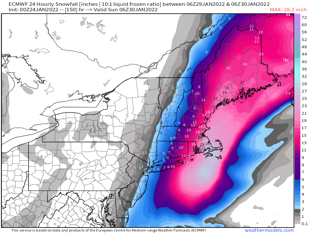
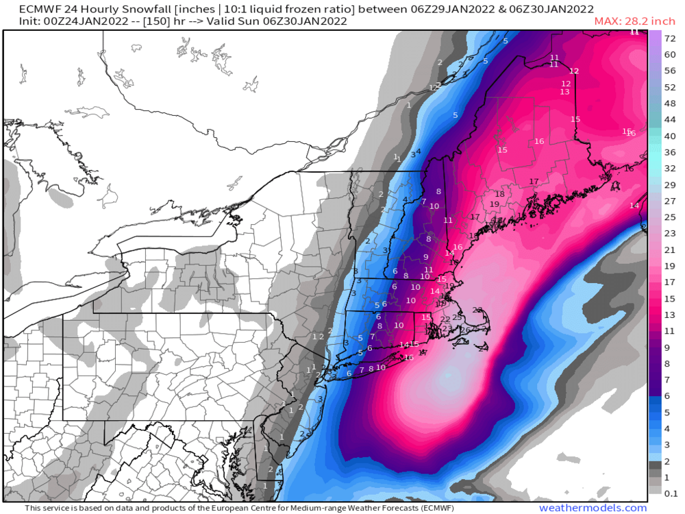
Tells the scale of this event: thread the needle is for historic, and we’ve seen exactly that depicted verbatim on reliable models… but lots of buffer for widespread warning+
-
Phasing happens just a tad later, H5 closes overhead / into gulf of ME, so we just miss the more epic solutions. It's close.
-
Slower, further west Huge hit eSNE 18z-21z Sat
-
0z GFS: Southern shortwave at 12z Friday is about 150 miles further east... should be more conducive to earlier phase
-
ICON made a big jump with handling of southern shortwave At 12z Friday, was previously over TX, now it's way back to NM/AZ border Not weighing it much compared to Euro / EPS, but another example of how sensitive this system is to the speed of that energy and downstream timing of phase
-
Yeah that run is a keeper. Goes warm core by Saturday too. A HECS verbatim. I wonder when was the last time we had a warm core blizzard. Question is what variation of that does reality take 4.5 days away.
-
Yeah pretty incredible Haven't had time to more than lurk today... will be back for the late night shift Vacillations between grazer and just outside BM are a good place to be
-
Yeah very strong signal... and exactly where I highlighted it on the 0z OP run ~hr 120-126 12z OP run seems like the outlier Guidance honing in on a big one... get rest folks, exciting week ahead!
-
EPS have > 15 members with 940s-960s near or just inside BM
-
Wish we could lock it in! But confidence significantly increased for a big hit.
-
As theorized earlier today... that was literally a jump of 200-300 miles west as a result of a better N-S stream interaction Great to see this on the Euro OP
-
Yep, 30 spots are in reach eastern MA
-
1-2 feet roughly ORH east, Cape Cod 20-30" Significantly builds confidence, lots of cross-guidance op and ens support It was a big shift at H5 (see my earlier post at hr 126, phasing over TN/KY) with drastic downstream impact:
-
Could see the differences early... look at this stream interaction over KY/TN at 0z vs. 12z: 0z: 12z:
-
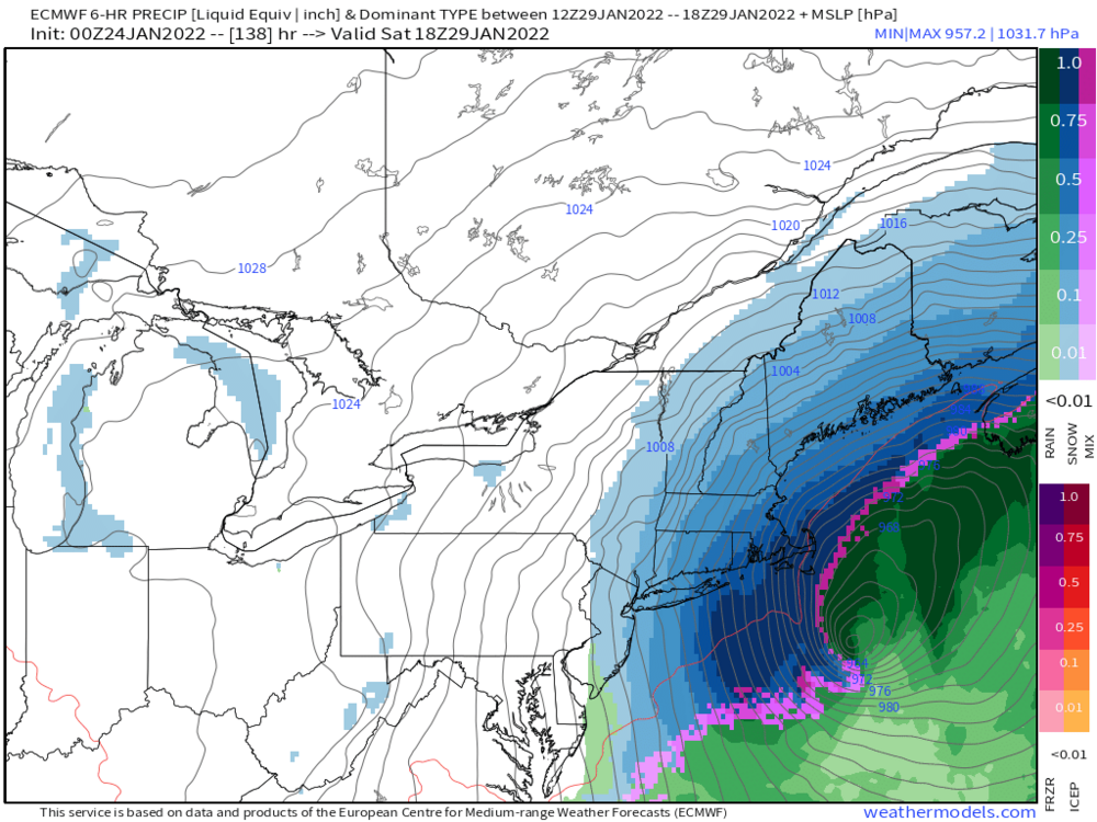
And there it is... blizzard on Euro op
-
This is gonna be a much better hit I think Through hr 126, already much better N-S stream interaction
-
GFS, CMC, UK... Euro is the only one of the big models that has not shown a blizzard at some point. Yet.
-
Pretty strong correlation in today's GFS runs, the hits (23 0z, 6z; 24 0z) vs. the ots (23 12z, 18z) tracks... if the southern stream energy does not get strung out, northern stream energy has a chance to interact and system amplifies close:
-
key difference is southern stream energy is a bit faster, and earlier interaction with northern stream energy
-
This is what the contemporary NFL wants. High scoring firework shootouts = more viewers. Bellichek’s defense-centric schemes seem outdated, not that they showed up last week.
-
Incredible game Was rooting for Bills… Kelce Hill etc already were sure they were dynasty legends years ago. Josh Allen will be a star for years
-
Oh Brady how we miss you Agree with ORH, this has the potential to snap back abruptly with just a touch more/earlier northern stream interaction