burrel2
-
Posts
2,388 -
Joined
-
Last visited
Content Type
Profiles
Blogs
Forums
American Weather
Media Demo
Store
Gallery
Everything posted by burrel2
-
The December to Remember 7th-8th blue turd winter threat thread.
burrel2 replied to lilj4425's topic in Southeastern States
00z JMA... continues to be cold and amped...would be a massive snow storm for the 85 corridor. -
The December to Remember 7th-8th blue turd winter threat thread.
burrel2 replied to lilj4425's topic in Southeastern States
Most of the ensemble members on the GFS are more bullsh with the westward extent of the precip shield compared to the OP. Maybe the JMA is on to something! -
The December to Remember 7th-8th blue turd winter threat thread.
burrel2 replied to lilj4425's topic in Southeastern States
It's all frozen for Western NC/SC(mby). Raleigh to Charlotte would most likely have mixing issues with that track. -
The December to Remember 7th-8th blue turd winter threat thread.
burrel2 replied to lilj4425's topic in Southeastern States
Liquid from 7am Friday to 7am Saturday -
The December to Remember 7th-8th blue turd winter threat thread.
burrel2 replied to lilj4425's topic in Southeastern States
12z JMA is a big dog! This is the best look possible, IMO. I hope it's on to something. Hard to tell with the crummy maps, but it looks like this is drop 1"plus of liquid across my area with supportive temps for snow. -
The December to Remember 7th-8th blue turd winter threat thread.
burrel2 replied to lilj4425's topic in Southeastern States
Confidence for me is increasing that we'll see some flakes and maybe a car topper. Confidence in anything more than that has decreased overnight, but there's still time for things to change drastically either way. -
Here comes the sustained -NAO now that winter is over.
-
Welp, stick a fork in this winter. It's over. Maybe we'll have better luck next year!
-
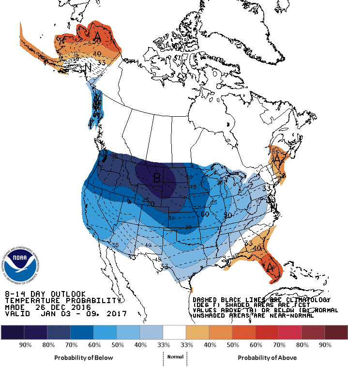
This gets us out to Feb. 15th....
-
Where is everyone? This thread looks like the place to be for the next several weeks....
-
Welp, Models took a turn for the worst last night. I see no realistic chance of snow for us over the next 10 days, with no sign of a decent pattern past that.... Winter cancel???
-
Yea... it was breathtaking, pictures don't do it justice.
-
Our rental car.... snow chains were a must.
-
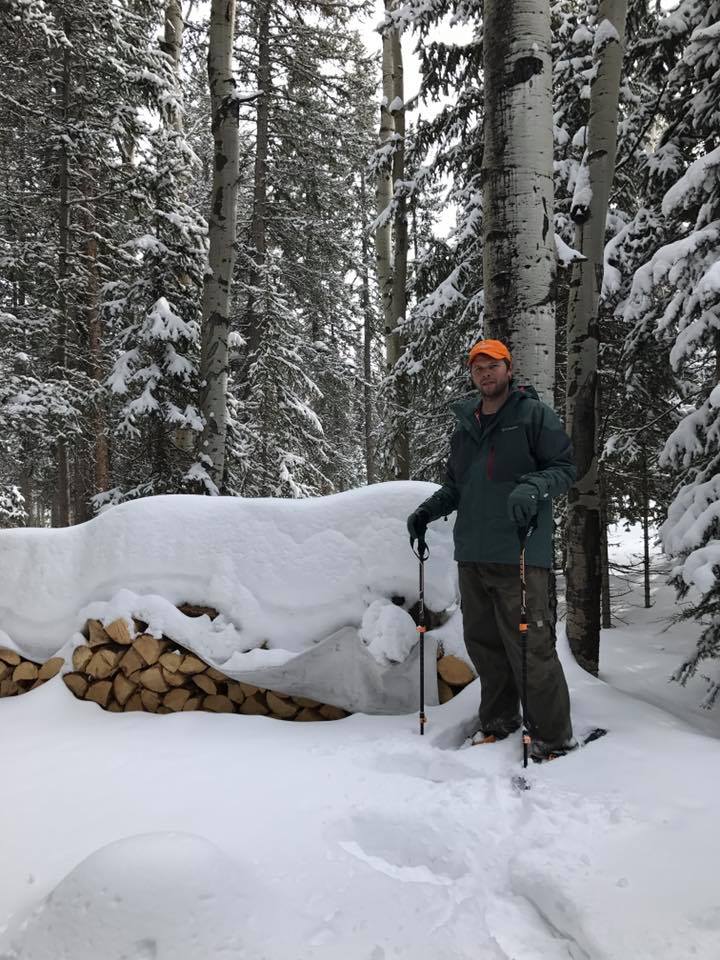
So the last 3 days we stayed in Crested Butte to go skiing. I thought I had seen a lot of snow at our cabin, (6ft). That was until we arrived in Crested Butte.... They had recieved over 100" in the last 5 days. The most snow they've gotten since 1980! It was INSANE!!!! This is what buried looks like.
-
My trip to our cabin in Colorado was a success.... Had to snow shoe in and out. They had gotten about 6 foot of snow in the last week. The snow was so deep that it had a blue'ish hue when you dug down deep enough! I was in heaven out there!

-
Shouldn't be a problem with the shortwave being so weak and surface low tracking so far to the south. Now, if this thing starts to crank up the coast then it might come in to play for NC people.
-
That look is for sure better than what the models have been showing. We can score without ridging out west if the ridge over greenland sets up that far to the west. Looks similar to 2011 when we scored. The Euro seems to be the only model trying to build a west-based negative NAO though, but maybe it'll be right?
-
I'm sure the mountains will get there share of snow before the season is over, we just need you guys to drop a few crumbs down to us.
-
The thing is, when the pattern looks good there are as many if not more useless post from people who are excited about the pattern, but no one seems to be bothered by those. lol
-
Stupid Southeast ridge.... congrats to the rest of the United States I guess.
-
Not sure why we can't discuss why the upcoming pattern doesn't look good in the long range thread? That thread is only reserved for positive talk about winter weather I guess...
-
I like freezing rain better b/c it sticks to trees and thus looks more wintry/beautiful. Plus you get the excitement of sagging limbs and popping/crashing tree's. Other than making the ground white, sleet just doesn't do it for me... 1. It doesn't accumulate very fast 2. No tree stickage 3. Can't make snow cream out of it 4. I usually have my hopes up for snow when I actually get accumulating sleet so its sort of a bummer when it happens.
-
I prefer snow, but beggars can't be choosers. I would rank my favorite precip types in this order: 1. Snow 2. Freezing Rain 3. Sleet 4. Rain