

Disc
-
Posts
4,052 -
Joined
-
Last visited
Content Type
Profiles
Blogs
Forums
American Weather
Media Demo
Store
Gallery
Everything posted by Disc
-
I don't live too far from the office, but will be an interesting ride. If I can make it out of the neighborhood to 460 I think I should be ok. If I had to commute from Roanoke I don't think I'd make it up Christiansburg Mountain.
-
Last good one (12"+) was Dec 2018 so it's been a little while. Before that one I'd have to go back to Feb 2014. I am going into work late Sunday night and will be working all night. I am rooting for an earlier starting storm for 2 reasons.. 1) This would mean less of a mixing concern here and (2 It would be over with by the time I have to go to work. The trends this morning have favored this so let's hope it continues.
-
Sleet is most likely. The depth of the CAD is very large. This is not the typical shallow CAD scenario.
-
We're sitting good up here. I'm not ready to say 12" is a lock, but the trends this morning have been good.
-
Pretty certain we'll be mixing at some point. Hard not to when there's a sfc low riding up I-95.
-
LP transfers to the GA coast early Sunday afternoon. 1001mb. Mixing in NC. Mtns do well.
-
Heavy snow breaking out across NC at 15z Sun.
-
Ukmet is 18" at DC on Kuchera clown map.
-
I really don't use it outside of 48 hours. It's fun to look beyond, but take it with a grain of salt.
-
I will say this: I have never made a forecast using the ICON model. Entertainment at best.
-
Yep, this is a money run for areas between US460 and I40.
-
ICON will be a big hit for southern VA.
-

2021-2022 Fall/Winter Mountains Thread
Disc replied to BlueRidgeFolklore's topic in Southeastern States
Rather underwhelming here. Might have an inch on the ground. Rates haven't been all that good and took until almost 7am to go to all snow. Glad to see others to the south doing well though. -
Still 36F and rain here. Not impressed with the trends at the moment.
-
2021-2022 Fall/Winter Mountains Thread
Disc replied to BlueRidgeFolklore's topic in Southeastern States
While I'm sure that's a bit overdone, it's obvious that this is a very dynamic system capable of some serious snowfall rates. My real concern today has been the trend with a later changeover from rain to snow. Some guidance is now showing we won't flip until 7-8am, with the precip moving out a few hours later. That's gonna leave a lot of folks disappointed. The change from rain to snow is never favorable around here as I'm sure you already know, but the thing going for us here is this being such a dynamic system and the lift is crazy. Here is a frame from the 00z NAM (10z/5am).. ..this frontogenesis band along the Blue Ridge means business. Although the model may indicate rain/mix at this timeframe and the surface is mid 30s, it's likely gonna be snow if you're under that. With lift and rates like that it will obviously cool the surface quickly. The change over to snow will be once this passes over. Older runs had this coming through sooner and we switch to snow sooner, thus better totals. Something to watch, but regardless we're still good for at least a few inches of paste. If we didn't have a surface low rapidly developing to the south, you wouldn't get the heavy rates, and in turn this would've likely been a cold rain for most. We're truly getting lucky here to be getting any snow. -
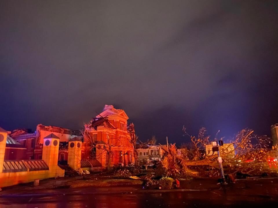
Another from downtown Mayfield.
-
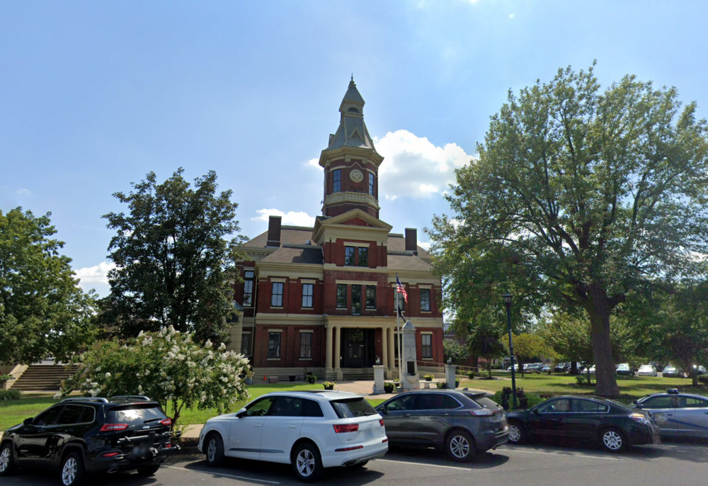
Mayfield courthouse.

-
Could be a fiber cut. If no internet and backups have failed, can't issue products. They will still be able to see the radar locally, but it's not getting out for the world to see.
-
I think PAH is down hard. Radar image is old. Springfield is doing full service backup.
-
I logged in just to mention this, but you already commented. Speechless.
-
It's been an interesting day...
-
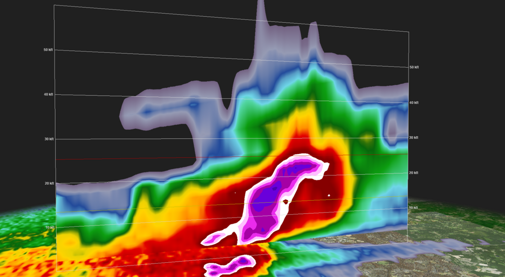
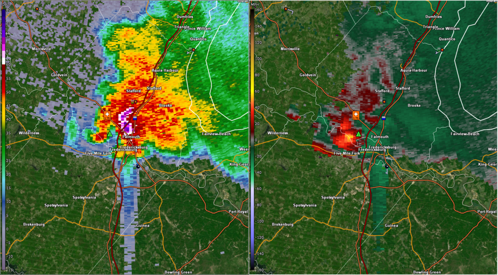
Insane TBSS. 72dbz to over 20kft = big hail. Fredericksburg just got whacked.
-
Went directly over a lumber yard just east of Centreville.
-
Glad you all are safe. Hoping the best for your property.
-
US 280 Doug Baker Blvd on https://algotraffic.com/ in Meadowbrook should almost be in the direct path. (Live traffic cam)


