Burghblizz
-
Posts
1,742 -
Joined
-
Last visited
Content Type
Profiles
Blogs
Forums
American Weather
Media Demo
Store
Gallery
Everything posted by Burghblizz
-

Western PA/Pittsburgh Winter 2021/22 Discussion
Burghblizz replied to meatwad's topic in Upstate New York/Pennsylvania
Yeah 18Z GFS is a crush job - but would definitely have to track perfectly as it seems to want to scoot along quickly. Really nice track though this run. -
Western PA/Pittsburgh Winter 2021/22 Discussion
Burghblizz replied to meatwad's topic in Upstate New York/Pennsylvania
Pretty familiar look from mid winter for the Saturday storm potential. Heavy snow or watching someone N or NW swipe it? Could go either way of course, but Looks like a Potentially rapidly deepening system laying the hammer down somewhere.
-
Central PA - Winter 2021/2022
Burghblizz replied to Bubbler86's topic in Upstate New York/Pennsylvania
We gusted over 60. Holy hell was it windy. At one point, the rain had all but stopped, but the wind was driving just the ponded water being kicked up by cars horizontally. Not sure I’ve ever seen that to that extent. -
Western PA/Pittsburgh Winter 2021/22 Discussion
Burghblizz replied to meatwad's topic in Upstate New York/Pennsylvania
March still has more snow on average than December, even with the most recent 30 year average. So winters ending with a dud isn’t a long term trend just yet. I’ll be out of town late next week, so I’ve had that targeted for awhile for a big storm. -
Western PA/Pittsburgh Winter 2021/22 Discussion
Burghblizz replied to meatwad's topic in Upstate New York/Pennsylvania
It’s a rain storm. So not really wasted since it was never in the cards. Beautiful day today. Hopefully something pops up after this system. -
Western PA/Pittsburgh Winter 2021/22 Discussion
Burghblizz replied to meatwad's topic in Upstate New York/Pennsylvania
I’m not watching every run this week if the GFS is in its own. (I say that now) -
Central PA - Winter 2021/2022
Burghblizz replied to Bubbler86's topic in Upstate New York/Pennsylvania
Yeah, we gusted close to 50 with whiteout conditions. 1” or so in 30 min -
Western PA/Pittsburgh Winter 2021/22 Discussion
Burghblizz replied to meatwad's topic in Upstate New York/Pennsylvania
Would love for it to lock in with the mix line in northern WV so we have some wiggle room -
Western PA/Pittsburgh Winter 2021/22 Discussion
Burghblizz replied to meatwad's topic in Upstate New York/Pennsylvania
Yeah I was thinking the same - ground blizzard at times with sun in between. Pretty cool. Second batch has arrived with heavy snow. Looks to be shorter lived. Also, the sun has been peaking through at times, despite snowing pretty heavily. -
Western PA/Pittsburgh Winter 2021/22 Discussion
Burghblizz replied to meatwad's topic in Upstate New York/Pennsylvania
The sun is going to be out in like 15 minutes there too — But it’s going to be OK. -
Only our area can get the “hot” designation in the complaint thread, on a morning with a free micro-blizzard, with no tracking needed
-
Western PA/Pittsburgh Winter 2021/22 Discussion
Burghblizz replied to meatwad's topic in Upstate New York/Pennsylvania
Dropped about 1” or so 30 minutes. The last 5 minutes was straight white out. Some pretty high gusts behind the squall. Getting occasional low vis with blowing snow now. -
Whiteout here too, weenie. Right thread
-
Western PA/Pittsburgh Winter 2021/22 Discussion
Burghblizz replied to meatwad's topic in Upstate New York/Pennsylvania
And it’s glorious. -
Then it’s confirmed. You are a troll that lives in Philly pissed off about your shitty area. If you are in the north hills, you do not have “flurries” right now.
-
40 MPH gust. Whiteout. But weenie on guys
-
Every weenie thinks that. Look at the snow hole in South central PA this year. Try a Philly or DC 2” winter. Anyway - ripping 2” per hour right now. Not sure if it last for an hour, but approaching a fresh inch. Nice last 30 days as I’m around 25”.
-
Western PA/Pittsburgh Winter 2021/22 Discussion
Burghblizz replied to meatwad's topic in Upstate New York/Pennsylvania
Wouldn’t be shocked to add a sneaky inch or two to that over the course of the day. I’ve had some squalls on and off so far. -
I’m just here for the comic relief.
-
Western PA/Pittsburgh Winter 2021/22 Discussion
Burghblizz replied to meatwad's topic in Upstate New York/Pennsylvania
Yeah - it’s not going to snow a foot Sunday. Just relaying the imagination of the Canadians at this point. -
Western PA/Pittsburgh Winter 2021/22 Discussion
Burghblizz replied to meatwad's topic in Upstate New York/Pennsylvania
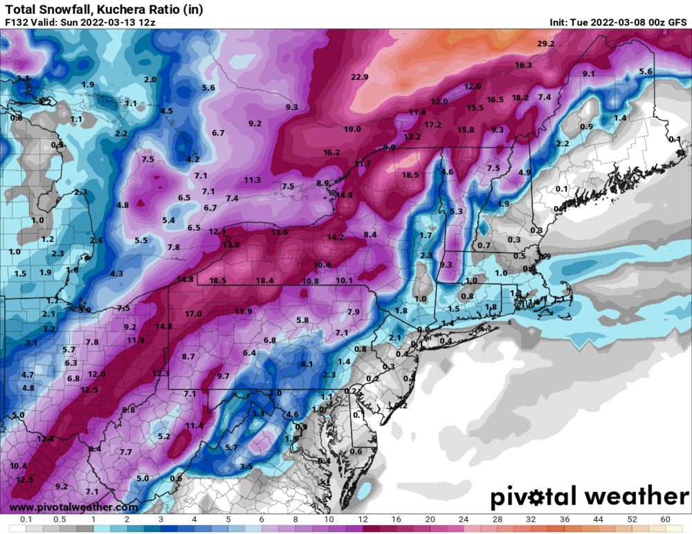
This shot has a thin weenie band that gets north of the city 12” all told - but the frames before this have good widespread snows -
If you want a decent reference site for local forecasts, this is it. Honestly, I think they are making the same mistake you are by using that brief moment where the 12” point and click contour made it down to Moon Twp. Also, Intellicast goes off of that I believe. The NWS statement was 6-12” and 6-11” at various times. So throw that in this bunch: But you’ll see this was the landscape of local forecasts. To pretty decent for a 9” storm. It’s the highest model and weenie dreams that didn’t verify. The forecasts did.
-
Western PA/Pittsburgh Winter 2021/22 Discussion
Burghblizz replied to meatwad's topic in Upstate New York/Pennsylvania
The map did, but they aggregate reports from earlier. So like I said, you can cross reference the report times in the PIS and LSR’s Not sure why you are so obsessed to show that 7” fell instead of 9” in a storm that was forcasted to get 6 to 11”. Anyway, take this to banter. -
Western PA/Pittsburgh Winter 2021/22 Discussion
Burghblizz replied to meatwad's topic in Upstate New York/Pennsylvania
Little batch of snow showers about to roll in. Won’t amount to much, but look nice falling into the snow pack. -
Western PA/Pittsburgh Winter 2021/22 Discussion
Burghblizz replied to meatwad's topic in Upstate New York/Pennsylvania
You brought it up. Linking a map. A map that includes early and mid event totals. Cross reference that with the PIS and the times of those reports. Sorry the storm underformed your expectations. It snowed 9.1”. Probably a little more here. Forecasts were fine. Every local, accuweather, and the NWS statement validated. Literally 30 posts because some dude at NWS briefly pulled the 12” contour down west of the city.