

Festus
-
Posts
599 -
Joined
-
Last visited
Content Type
Profiles
Blogs
Forums
American Weather
Media Demo
Store
Gallery
Posts posted by Festus
-
-
Squall warning expired. Seemed a bit much at least for me. Never dropped below 1/4 mile. About 3/8 right now.
-
* Snow Squall Warning for...
Lancaster County in south central Pennsylvania...
Southeastern Adams County in south central Pennsylvania...
York County in south central Pennsylvania...

* Until 915 AM EST.

* At 828 AM EST, a dangerous snow squall was located along the
leading edge of an area of heavy snow extending from near Dover to
near Littlestown, moving east at 40 mph.
-
Advisory issued...
229 PM EST Sun Feb 21 2021

...WINTER WEATHER ADVISORY IN EFFECT FROM 8 AM TO 3 PM EST
MONDAY...

* WHAT...Snow expected. Total snow accumulations of 1 to 3 inches,
  with up to 4 inches possible across the higher terrain along
  Interstate 81 in Schuylkill County and over Sullivan County.
  Winds gusting from the south up to 30 mph on the ridges.

* WHERE...Portions of central Pennsylvania.

* WHEN...From 8 AM to 3 PM EST Monday.
-
 1
1
-
-
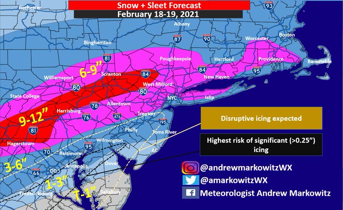
Posted by one of the mets in the MA forum. I vote let's just go with this and close the thread from further discussion.
-
 1
1
-
 1
1
-
-
11 minutes ago, Itstrainingtime said:
I'm every bit as ugly in person as my pic suggests.
This has been talked about before, we really should do this.
A lot of you guys are very impressive in terms of weather prediction skills. And I'd imagine most are self taught which is even more impressive. I did 2 years of Meteorology at Millersville before switching majors (Barry Walton era - yikes) and we would draw isobars and isotherms by hand (double yikes). Always interested in weather but some of you really take it to the next level. And yes, a meeting would be fantastic.
-
Crazy reading the last page or 2 how close so many of us are geographically yet experience such different results this time of year. Whenever covid eases, we should have a gathering. I can only imagine how different most of us are in person versus how we are perceived on this board.
-
1
-
-
York and Lancaster WSW version -
WHAT...Heavy mixed precipitation possible. Total snow
  accumulations of 5 to 7 inches and ice accumulations of up to
  one tenth of an inch possible.

* WHERE...York and Lancaster Counties.
-
There's been a lot of understandable frustration with models this winter but just realize what what they are up against...ridiculously complex thermo and fluid atmospheric dynamics coupled with inadequate sampling. Then trying to pinpoint individual feature days in advance from features hundreds if not thousands of miles away. I think it's a miracle they even get close.
-
WWA was updated down this way from this morning's 2 - 3" to:
208 PM EST Wed Feb 10 2021

...WINTER WEATHER ADVISORY NOW IN EFFECT FROM 6 PM THIS EVENING
TO 9 AM EST THURSDAY...

* WHAT...Snow expected. Total snow accumulations of 3 to 5
  inches.

* WHERE...Portions of south central Pennsylvania.

* WHEN...From 6 PM this evening to 9 AM EST Thursday.
-
Light snow, temp 33, roads wet. Meh.
-
Winter Storm Watch issued by LWX for Maryland Mason-Dixon border counties and Chester county on east.
-
At least we don't have to chase models anymore now that we have the groundhog forecast coming out. That was exhausting.
-
1
-
-
Just now, Itstrainingtime said:
Just to your west by about 10 miles, I'm in very light snow now. Borderline flurries. 8.1" storm total.
Man that's crazy. It is pounding here. We're gonna see some weird storm totals from this one.
-
6 minutes ago, paweather said:
They are under one the great bands that last for hours, hope it would rotate west but I doubt it.
I think central and eastern Lanco getting some scraps from that and it's not too shabby. I'm back to under 1/2 mile at the moment.
-
Looks like the bands of doom are approaching Reading dropping SW. If those hold together...holy moly.
-
1
-
-
Just heard from Eli Stolzfus down the street. He said "it's makin' dawn naw!" Visibility 1/4 mile here.
-
Silence finally! No more sleet pounding against the house. Pivot axis SE of PHL and filling a bit. Plenty o' duration to go.
-
Seeing some shredded flakes mixed in (perhaps a new breakfast idea). Appears changeover is imminent here. Glad I did not shovel yet. Don't want all this crap on the bottom.
-
4 minutes ago, Itstrainingtime said:
Well, Horst is getting excited about the remainder of the day. Says that conditions will rapidly deteriorate this afternoon and told people to think about heading home from work now.
Tweet - "Coming up on Noontime, and the 3rd Act is beginning! There's still a bit of warm air aloft (causing sleet), but this layer will cool as heavier precip develops the next few hours. Travel conditions will deteriorate quickly this afternoon, so it would be prudent to get home soon!"
-
-
Dammit. Now I need to revise my MDT guess for the contest i'm not in. Is it acceptable to just go with the Roger at 8 - 50"?
Seriously, I cannot imagine being an NWS met with this one where your forecasts have so much impact one way or the other.
-
1
-
2
-
-
Latest CTP AFD (is it too late to enter the MDT snowfall contest?):
A long duration winter storm will continue to impact central PA
through Monday night. We will transition from phase 1 of the
storm to phase 2 as the primary sfc low weakens over the OH
Valley tonight and energy transfers to a strengthening coastal
low offshore the Delmarva/NJ.

Hires models particularly the HREF/HRRR are showing dry slot
penetrating into the lower Susquehanna Valley after midnight,
and in response we expect snow to change to or mix with sleet
and freezing rain into early Monday morning.

The gradient between deepening coastal low and high pressure
over the Canadian Maritimes will result in an anomalous easterly
flow focused into eastern PA. Expect wintry mix to transition
back to snow by midday Monday with increasing snow rates through
Monday afternoon. 12Z HREF was not that bullish for >1"/hr rates
showing highest probs running along the CWA border btwn BGM and
CTP. Models continue to show fgen band setting up in the
deformation zone and pivoting over east-central into northeast
PA Monday evening and into Monday night.

The key takeaway for the dayshift cycle was an overall reduction
in storm total snowfall supported by the HREF mean/extended
range 12/18Z HRRR and backed by a WPC/NBM blend, with a shift
in max snowfall amounts (10-15+" range) toward the Poconos/NEPA.
Local CWA max is in Sullivan County pushing 1.5 feet/18 inches.

There could be some changes in the Monday night period as model
spread increases with the orientation and intensity of pivoting
fgen/deformation band. We were keen to place the highest POPs
and heaviest snowfall over the NE zones.

As the coastal low deepens, gusty northerly winds are expected
over the far eastern parts of the area with max gusts in the
30-35 mph range early Monday.
-
Just the finest of flakes visible here. DP 14 but improvement over the 9 it was an hour ago.
-
13 minutes ago, MillvilleWx said:
May I enter sir?
")
16.7" on 1.36
Hmmm...your snow map in the MA thread has MDT in the 8 - 15" zone with local to 18". Maybe some insider knowledge on the "local to 18"?
-
1
-

Central PA - Winter 2020/2021 Part 2
in Upstate New York/Pennsylvania
Posted
Dang! I want what y'all been getting. My 1/4 mile marker still clearly visible. Hopefully soon!