

Festus
-
Posts
599 -
Joined
-
Last visited
Content Type
Profiles
Blogs
Forums
American Weather
Media Demo
Store
Gallery
Posts posted by Festus
-
-
If modeled snow actually happened…
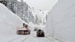 Reality…
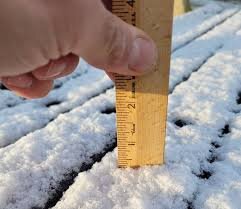
-
 1
1
-
 2
2
-
-
Heating that 0 dewpoint air to 70 gives an RH of a whopping 6% Probably the thing I detest the most is the feeling of moisture getting wicked away from every nook and cranny. And for today's interesting fact, the global highest temperature in the past 24 hours was 115 in Australia. And the coldest was -66 in Russia. In fact, the top 15 coldest past 24 hour readings were all from Russia. No wonder they want to invade Ukraine. At least it's a little warmer there.
-
1
-
1
-
-
Climate Prediction Center long range forecast released yesterday shows way below average temperatures for the next 6 - 10 days, average for days 8 - 14 and a February torch for their 1 month outlook.
-
1
-
-
1 minute ago, paweather said:
Palmyra has a WWA
Yep. CTP southeast counties just added.
-
1
-
-
WWA issued for Berks and Chester counties down this way.
...WINTER WEATHER ADVISORY IN EFFECT FROM 3 AM TO 11 AM EST
THURSDAY...

* WHAT...Snow expected. Total snow accumulations of up to 2
  inches, with local amounts up to 3 inches possible.

* WHERE...Portions of northern New Jersey and eastern
  Pennsylvania.
-
All this long range eye candy is making me giddy. Since it takes a little over a month for air to traverse the globe, maybe the southern storm can come back around a little more tucked next month. Now we just need to lobby for a 768 GFS panel. And how does Accuweather manage those daily forecasts 3 months out anyway? Calling for a little rain on Easter Sunday (April 17th). Bummer. But at least the high will be 66.
-
2
-
 1
1
-
-
Thackara just forecasted 2 - 3" for York and Lancaster and less N & W based on "updated guidance". Therefore, max will be a coating lol.
-
Well this sucks. No model showing anything. Anyone have access to the GRAPES model (Chinese)? That's gotta show a MECS to at least induce some panic.
-
39 minutes ago, Festus said:
As we debate the various X-ECS, riddle me this. If you could design the perfect winter storm for PA, how would it evolve, what features would be where and when, etc. Must use parameters that are in the realm of possibility.
Agree on early January and cold leading up to event so no surface temp or sun angle shenanigans. Would need some kind of bomb and stall or crawl scenario. At least 60 - 72 hour duration. Thundersnow in the evening for max effect (Cantore doing live feed and chasing the lightning would be icing on the cake). Also agree on not too much wind as power outages not cool. 30 - 40" for most. Want to get right on the edge but not risk structural collapse. Probably pressing that a bit at 3' though. So max snow but minimal damage to life and property.
-
2
-
-
As we debate the various X-ECS, riddle me this. If you could design the perfect winter storm for PA, how would it evolve, what features would be where and when, etc. Must use parameters that are in the realm of possibility.
-
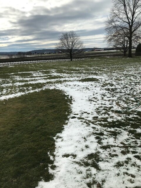
The literal "in my backyard" pic. Sure hope most of you folks are a little whiter. And what's up with Wednesday night? All of a sudden I have a Snow Likely in my grid forecast.
-
 5
5
-
-
39/37 with grass showing through and some spots bare already. With DP above freezing, my "snow pack" is on life support. Meh, next.
-
Just started.
-
26/15 here. Blue on the radar and the sky has "the look" but flakeless so far.
-
13 minutes ago, Atomixwx said:
Nevermind. They went with WWAs at 3:00 lol
Yup. Definite downgrade for those a few counties deep west of the river. And my grid forecast says gusts to 50 on Monday. Wind Advisory lurking.
A chance of rain and snow before 4pm, then a slight chance of snow. Cloudy, with a high near 39. Breezy, with a south wind 9 to 14 mph becoming west 17 to 22 mph in the afternoon. Winds could gust as high as 50 mph. Chance of precipitation is 30%. New precipitation amounts between a tenth and quarter of an inch possible.
-
10 minutes ago, MillvilleWx said:
No problem! There's a method to the madness. One of the biggest things I utilize is the CIPS analogs with recognition of key features and then compare to previous events. I also have a pretty good memory for weather, so I remember setups with a similar evolution in certain areas of the forecast and weight that towards guidance. Blending guidance can be good for a complex situation, but sometimes intuition with the meteorology at hand can take precedence, especially for something historical or heavy climo based (Elevation dependent storms are big with this). Knowing your geography and how things typically unfold is important.
Nailing forecasts exactly is extremely difficult, but the key is to stay within a bounds that can verify an Advisory or Warning when you put one out. As an NWS met, I think about being within reason and adjustments up are okay compared to adjustments down. Impact based forecasting. I want to be as close to right as possible, but not missing too much. In this case, it's hard to create a forecast when the transition time frame is uber important. That can make or break a forecast.
Thanks. Very interesting and enlightening. WAY back when (we're talking the Barry Walton era), I was a Meteorology major at Millersville but alas, I switched to Physics and and moved on from there. But I've always retained weather as a hobby and have the upmost respect for those who practice the craft in the real world. Your outputs can effect and in many cases save people's lives. Thanks for your work. It is much appreciated!
-
1
-
-
3 minutes ago, Mount Joy Snowman said:
For my big winner, I'm sticking with my call from a few days ago -- Mt. Mitchell, NC.
As for IMBY, I'll put the Over/Under for snowfall in Lancaster at 1.5". Sadly.
I think the "official" measurement will be over but it will be so squished and watered down by Monday morning the it will look like 1" tops. And that's what the non-weenies will say happened and harass the mets for busting.
-
6 minutes ago, MillvilleWx said:
No problem! I think in a local sense that area will have a higher chance of being impacted moderately to major. The elevation factor is key for them with orographic enhancement of the precip locally while locking in the cold temps at the surface. Blended guidance was fairly bullish for their impacts, so that is key in this forecast from myself. Those topographic features are important for an event like this. I honestly COULD be a little low on snow totals across the MD line, but it'll be +/- 1-2" max, so I'll hold what I have for the time being. Stay safe up there!
Quick question - when you analyze a complex storm like this and have to nail down an exact forecast, what's the mechanism? Do you just blend model output or factor in some forecasting experience that no model can reproduce? If the latter, what's the relative weighting? Just curious how it works in your world. Thanks!
-
2" -4" in my grid forecast. Guessing the consolation prize of a WWA forthcoming sometime this afternoon. Certainly not commensurate with the amount of time I spent on these boards the last week lol.
-
1
-
-
York now added to the WSW. Kudos to whoever said the river would be the dividing line.
-
 1
1
-
-
If the winds verify, that's going to be as big or bigger story here. I haven't gusted north of 60 in a long time.
-
Looks like the blue / grey line bisects my house. Hopefully the 3" is on the driveway side so I have less to shovel.
-
1
-
-
That gradient between the have's and have nots is pretty sick. With features still roughly 2000 miles away, +/- 25 miles around here will have huge implications.
-
1
-
-
2 minutes ago, Itstrainingtime said:
Out to hour 48 SLP approaching Little Rock, AK.
Thanks for bringing us back from the abyss, And thanks for the PBP.
Central PA - Winter 2021/2022
in Upstate New York/Pennsylvania
Posted
As has been the case here recently, blue overhead on radar, slate gray sky ... and ... bupkis. DP is 16 so sure looks like bupkis will continue for quite a bit longer.