

Festus
-
Posts
656 -
Joined
-
Last visited
Content Type
Profiles
Blogs
Forums
American Weather
Media Demo
Store
Gallery
Posts posted by Festus
-
-
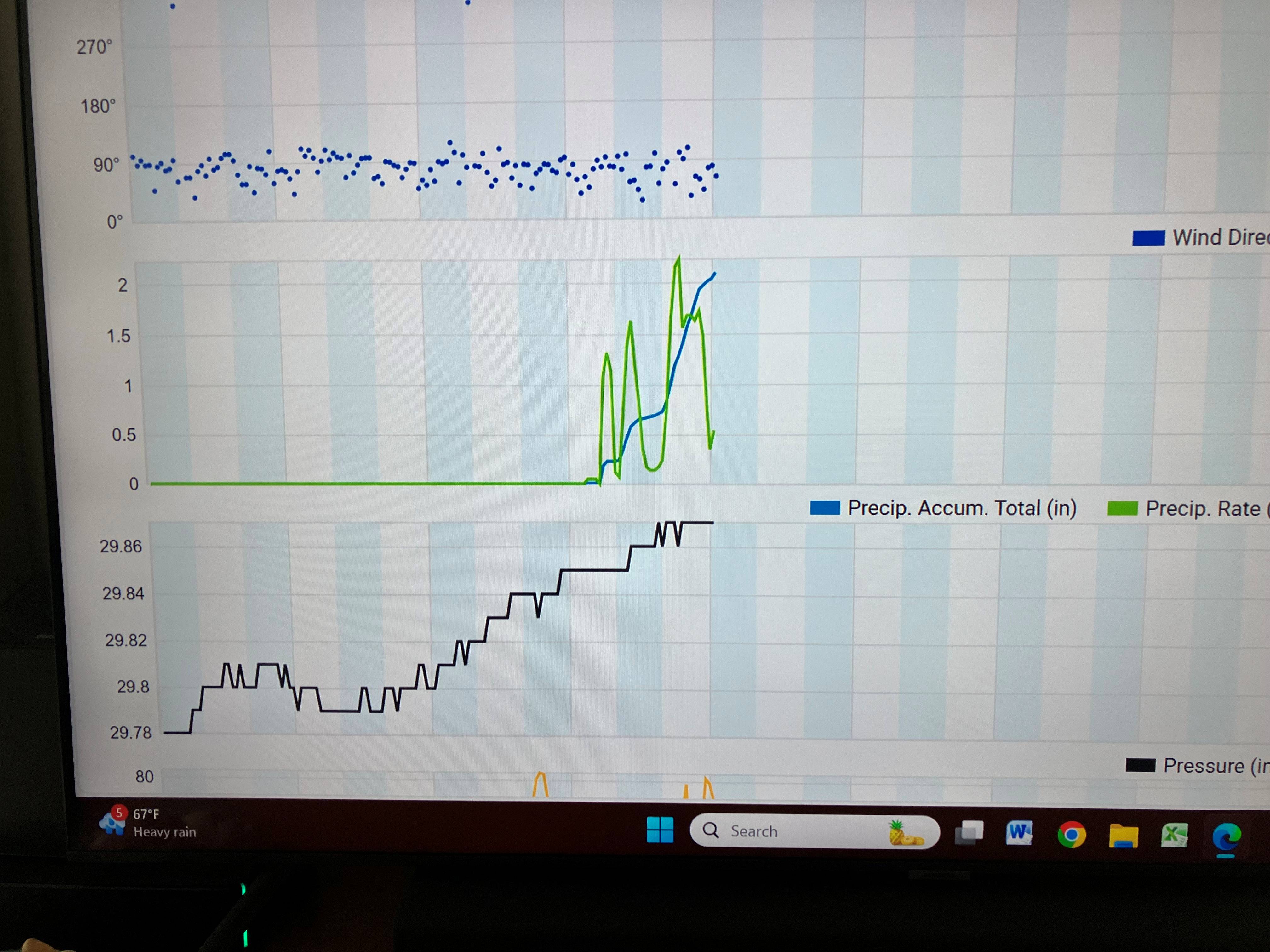
3.87" so far today. Upstream (literally, lol) radar continues to fill in so maybe shot at 5". Absolutely unreal.
So what's the mechanism for this mesoscale training over such a relatively small area?
-
 1
1
-
-
From the station about 100 yards away...

-
2
-
-
Holy moly - Just under 2" in the last 1.5 hours and still raining hard. Local roads passable (at least where I am) but need to drive down the middle. Didn't see this coming.
-
3
-
-
Another Millersville record low max temperature set yesterday. High was 56 breaking the old record of 57. That's two record low max temps set 6 days apart from two different systems with data going back over 100 years. Remarkable.
-
5
-
-
On 5/22/2025 at 7:51 AM, Festus said:
Just missed the Millersville record low maximum temperature yesterday. Record was 56, was 57 just after midnight.
Today's record low max is a relatively balmy 60. Should have no problem breaking that one, unfortunately.
Millersville high yesterday was 56 breaking the low max temperature record by 4 degrees.
-
3
-
-
Just missed the Millersville record low maximum temperature yesterday. Record was 56, was 57 just after midnight.
Today's record low max is a relatively balmy 60. Should have no problem breaking that one, unfortunately.
-
4
-
-
58 minutes ago, Itstrainingtime said:
I think I had a gust about 30 minutes ago that was stronger than anything since Isabel here. My trashcan is gone. Don't want to exaggerate but it had to be 60+.
Absolutely agree. We have an open southern exposure and I cannot recall such a sustained event. Next door neighbor's large willow was toppled a few hours ago. KLNS reported a 52 gust but I'm sure I've had stronger than that here.
-
1
-
-
20 minutes ago, canderson said:
Whatttttt? I read somewhere it was March 2! Geez.
Daylight Savings Time begins on the second Sunday in March and ends on the first Sunday in November. So the earliest it could ever change in March is the 8th.
-
1
-
 1
1
-
-
it's mid February, so I do my usual check in here to catch up on the latest winter threats. I see a page of geography.
Not a good sign.
-
 3
3
-
-
Slow day so here's the list of most prolific regular posters in our forum. Apologies if I missed anyone. In thousands rounded to the nearest hundred:
1 Bubbler86 29.6 2 mitchnick 26.1 3 Canderson 23.3 4 Itstrainingtime 19.1 5 Sauss06 13.3 6 Voyager 12.0 7 Blizzard of 93 11.6 8 Paweather 11.4 9 Pasnownut 9.5 10 ChescoWx 8.9 11 MAG5035 5.9 12 WmsptWx 5.5 13 DDweatherman 5.2 14 Jns2183 4.7 15 mahantango#1 3.9 16 Mount Joy Snowman 3.8 17 Superstorm 3.8 -
3
-
 1
1
-
 1
1
-
-
Nothing compared to some of you but my upwind neighbor has a bunch of locust trees. I now have several thousand of those big ass seed pods covering my yard. Man I hate those trees.
-
 1
1
-
-
Just now, anotherman said:
No one was ready for today. Completely oblivious.Yeah, I agree with that but holy shit, just slow the eff down. It's not THAT hard.
-
I swear Lancaster County has the worst drivers on Earth. 32 accidents on the 911 list, 3 with entrapment. Wtf?
-
When it comes to forecasts, most locals I talk to or overhear usually cite output from WGAL or WHTM (and rarely, the NWS, sadly).
I'm guessing most of our family, friends, coworkers, etc know we're weather weenies and look to us as "being in the know". So when you provide the latest to them, what's your method? Average the latest model runs in your head and customize a forecast? Weight output from the NWS a little heavier? A favorite source here or elsewhere? Don't touch the subject with a ten foot pole?
-
Didn't Accuweather have forums at one point? I seem to recall they were a train wreck but don't remember the specifics.
-
Micro flakes here but flakes nonetheless.
-
1
-
-
Cumulative GFS 200+ hr so far this season (not sure if Kuchera or 10:1
") )
)
-
3
-
3
-
-
LWX downgraded the Maryland border counties to a WWA. 2-4". Not a great sign for any last minute northern creep.
-
Looking over CTP winter event history, the most recent significant ice storm around these parts was January 1, 2021.
-
Traffic accident extravaganza down this way this morning. 14 right now on the 911 Incident list. Be careful out there.
-
2
-
-
42 minutes ago, Bubbler86 said:
Qyite the turn around in the last 18 hours. It looked like the Team SER was about the take control and now the GFS is running 2/5 under us. Some big changes. Were it not for a lack of cold air, the 6Z GFS would be a train of snow storms vs. the ice to rain scenarios they show right now for the 5th and 9th (not much rain on the 9th.) 3 winter storms on the 6Z GFS between now and Valentines day.
Forecast for Punxsutawney tomorrow is cloudy. Looks like you and Mitch are going pretty far out on a limb in using models versus a rodent.
-
3
-
-
In less than 24 hours, great to see POTUS has already found the root cause that being DEI.
The bottom is calling asking if we're there yet.
-
Wind Advisory hoisted for most of us. Gusting to 50 or maybe 60 at Canderson's wind tunnel.
-
1
-
1
-
-
With our epic cold snap now in the rearview mirror, the AVERAGE coldest day of the year for Harrisburg is January 29th. Interesting that the coldest day is pretty much in December for western USA and late January or even early February in eastern USA.
Interactive map: Coldest day of the year across the United States | NOAA Climate.gov
Central PA Summer 2025
in Upstate New York/Pennsylvania
Posted
4.99" yesterday + 0.21" since midnight = 5.20" for East Petersburg. Holy f-bomb Batman.